Nearby
Views from the Pineapple Track
Pineapple Track- Skyline Walk GPX
GPX file
•
Distance: less than 100m away
A GPX file of this popular walk
More ▶︎
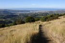
Pineapple Track - Skyline Walkway
Track
•
Easy. One way.
•
Distance: 1.1km away
This is an easy and popular track that gives great views of Dunedin city
More ▶︎
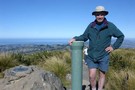
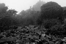
Flagstaff Summit
Photograph
•
Distance: 1.9km away
From the Summit of Flagstaff you get a 360 degree view of the Dunedin area
More ▶︎
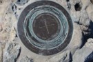
Flagstaff Plane Table
Photograph
•
Distance: 1.9km away
The plane table on the top of Flagstaff
More ▶︎
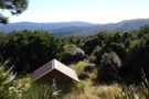
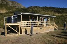
Ben Rudd's Shelter
Photograph
•
Distance: 2.2km away
A picnic shelter only, no bunks or facilities but a good view of the Silver Peaks from the Linda Mercier ...
More ▶︎
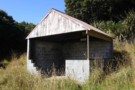
Ben Rudd's Shelter
Hut
•
Shelter (PVT).
•
Distance: 2.2km away
Owned by the Otago Tramping and Mountaineering Club this shelter is on a 44ha property owned by the club.
More ▶︎
Mount Cargill
GPX file
•
Distance: 5.4km away
Visit the Organ Pipes and the summit of Mount Cargill in Dunedin.
More ▶︎
Dunedin
Place
•
Place. 3314.80km2.
•
Distance: 5.9km away
The second-largest city in the South Island, located at Otago Peninsula south of Christchurch.
More ▶︎
Organ Pipes
Track
•
Easy. Return via same track.
•
Distance: 6.8km away
A brisk climb to an outcrop of basalt columns with views across the Otago Peninsula.
More ▶︎
Otago Tramping and Mountaineering Club
Club
•
Distance: 7.8km away
One of the oldest Tramping Clubs in New Zealand, founded 1923.
More ▶︎
Silver Peaks-Jubilee Hut
Track
•
1 – 2 days. Easy/medium. One way.
•
Distance: 8.4km away
This is probably the easiest way to get to Jubilee Hut from Dunedin. There is a shorter route up Christmas ...
More ▶︎