Nearby
Ōpārara Arch
Ōpārara Arch
Track
•
Easy. Return by the same track.
•
Distance: less than 100m away
Short walk to a limestone arch in the Ōpārara Basin.
More ▶︎
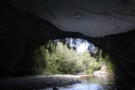
Moria Gate Arch
Track
•
Easy. Loop track.
•
Distance: less than 100m away
A short walk in the Ōpārara Basin, exploring the Moria Gate limestone arch.
More ▶︎
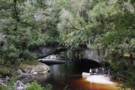
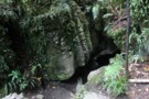
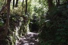
View upstream from under Oparara Arch
Photograph
•
Distance: less than 100m away
This photo was taken in May 2015. It is a short walk from a public carpark and shelters to the ...
More ▶︎
Moria Gate Arch
Photograph
•
Distance: 663m away
A film crew works at the limestone arch over the Ōpārara River.
More ▶︎
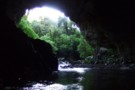
Descending into Moria Gate Arch
Photograph
•
Distance: 691m away
Limestone arch on the Ōpārara River.
More ▶︎

Exploring Moria Gate Arch
Photograph
•
Distance: 691m away
Limestone arch on the Ōpārara River.
More ▶︎
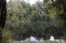
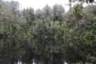
Mirror Tarn at Oparara
Photograph
•
Distance: 968m away
Mirror Tarn in the Oparara Basin. Fantastic area with limestone arches, caves, virgin bush. 16km gravel road from the highway ...
More ▶︎
Box Canyon and Crazy Paving Caves
GPX file
•
Distance: 1.2km away
Access to a pair of open caves at Ōpārara.
More ▶︎
Box Canyon and Crazy Paving Caves
Track
•
Easy. Return by the same track.
•
Distance: 1.2km away
Very short walk to two interesting easy-access caves
More ▶︎
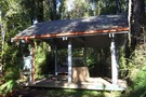
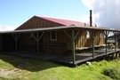
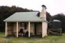
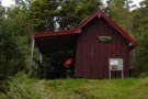
Sunshine Flat Shelter May 2015
Photograph
•
Distance: 2.5km away
An open sided shelter with wooden floor just off the Oparara Valley Track in Northern Buller, West Coast.
More ▶︎
Sunshine Flat Shelter
Hut
•
Shelter (NA).
•
Distance: 2.5km away
An open sided shelter with a wooden floor. It is located just off the Oparara Valley Track, Northern Buller, West ...
More ▶︎
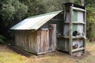
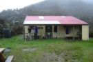
Adams Flat Hut
Hut
•
Basic Hut/Bivvy (DOC). Capacity: 2.
•
Distance: 5.5km away
A historic hut on the Fenian track, Kahurangi National Park
More ▶︎
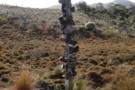
Fenian track Sept 2011
Photograph
•
Distance: 5.5km away
This photo shows a small cutting on the Fenian track. This pack track was constructed in the 1880's to provide ...
More ▶︎
Kohaihai Shelter
Hut
•
Shelter (DOC).
•
Distance: 8.0km away
Free public telephone, information, camping area.
More ▶︎

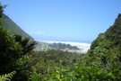
Heaphy Coastline
Track
•
1 – 2 days. Easy. Return via same track.
•
Distance: 8.0km away
An easy overnighter along the palm-fringed coastline of the Heaphy Track.
More ▶︎
Zig Zag Track
GPX file
•
Distance: 8.1km away
Short walk to a viewpoint at the end of the Heaphy Track.
More ▶︎
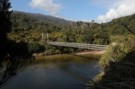
Kohaihai
Photograph
•
Distance: 8.2km away
Swing bridge over the Kohaihai River at the southern end of the Heaphy Track
More ▶︎
Heaphy Track
Track
•
4 – 6 days. Easy. One way.
•
Distance: 8.2km away
A classic crossing of the geologically and biologically diverse northwest corner of the South Island.
The track is also open to ...
More ▶︎
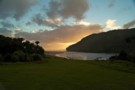
Sunset at Heaphy Hut
Photograph
•
Distance: 8.8km away
In front of the hut looking out to the mouth of the river. Sun setting in paradise!
More ▶︎
The infamous Boot Pole
Photograph
•
Distance: 8.8km away
Right in the middle of Gouland Downs. About 10-15 minutes on from the picnic table thats also a bit out ...
More ▶︎
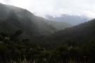
Coming off Perry Saddle down into Gouland Downs
Photograph
•
Distance: 8.8km away
The last of the rain, looking down to Gouland Downs
More ▶︎

Great Walks Information
Article
•
Distance: 8.8km away
The DOC Great Walks are a set of premium tramping tracks throughout New Zealand.
More ▶︎
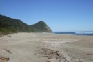
Scotts Beach July 2010
Photograph
•
Distance: 9.9km away
Looking south toward Kohaihai Bluff.
More ▶︎
Scott's Beach
Track
•
0 – 2 days. Easy. Return via same track.
•
Distance: 9.9km away
Beautiful walk to a golden, palm-edged beach and camping area at the end of the Heaphy Track
More ▶︎