Nearby
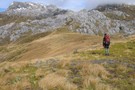
Mount Owen - northern approach from Courthouse Flat
Blue Creek Track
Track
•
Easy. Return by the same track.
•
Distance: less than 100m away
This short walk sets off from the site of a gold mining town, exploring mining relics and a river resurgence.
More ▶︎
Mt Owen via Sunrise Peak, return Fyfe Rive
Track
•
3 days. Hard. Loop track.
•
Distance: less than 100m away
Southern approach to Mt Owen, steep terrain, epic rock formations on the tops - making for stunning views but slow ...
More ▶︎
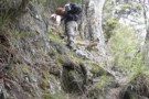
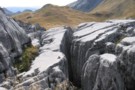
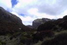
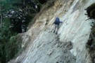
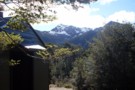
Granity Pass Track
Photograph
•
Distance: less than 100m away
steep part of track leaving granity pass Hut
More ▶︎
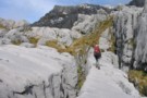
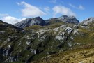
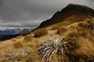
Route up Mt Owen
Photograph
•
Distance: less than 100m away
Following an easy, cairned route through a spectacular marble landscape to the summit.
More ▶︎
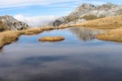
Alpine Tarn
Photograph
•
Distance: less than 100m away
Alpine Tarn in the basin below Mount Owen when approaching from Granity Pass Hut. Approximately one hour below the summit.
More ▶︎
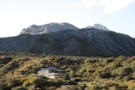
Mount Owen
Photograph
•
Distance: less than 100m away
Looking at Mount Owen from an hour below the summit
More ▶︎
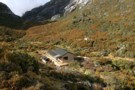
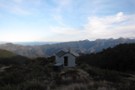
Granity Pass Hut
Photograph
•
Distance: less than 100m away
Looking back at Granity Pass Hut from the route to Mt Owen
More ▶︎
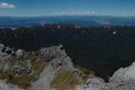
Mt. Owen Panorama
Photograph
•
Distance: less than 100m away
Mt. Owen in Kahurangi National Park. 1875m.
More ▶︎
Courthouse Flat campsite
Campsite
•
Basic Campsite (DOC). 25 spaces.
•
Distance: less than 100m away
Wide grassy camping in the Wangapeka Valley. A common access point onto Mount Owen via Granity Pass Hut. A number ...
More ▶︎
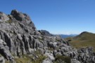
Mt Owen
Photograph
•
Distance: less than 100m away
Amazing texture in the rocks (called marble, though I'd just say limestone) around this area.
Mt Owen, Kahurangi National Park, South ...
More ▶︎
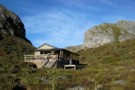
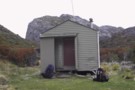
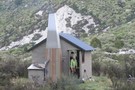
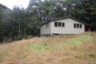
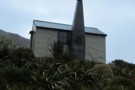
Granity Pass Hut
Hut
•
Standard Hut (DOC). Capacity: 12.
•
Distance: 175m away
New DOC hut with 12 bunks. Rain catcher for fresh water only so you must go well supplied, can be ...
More ▶︎
granity pass huts
Photograph
•
Distance: 286m away
yes huts. For a brief period the old and new huts were present together on Mt Owen.
More ▶︎
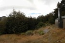
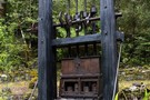
Culliford's Battery
Photograph
•
Distance: 1.3km away
A temporary four-stamper in Blue Creek near Mount Owen. A quartz reef was discovered here in 1870 by Alfred Culliford. ...
More ▶︎
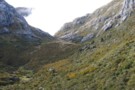
Mt Owen - Fyfe River country
Photograph
•
Distance: 2.0km away
This photo has been posted to illustrate the "Track" article by "nshaw" about travelling between Mt Owen or Sanctuary Basin ...
More ▶︎

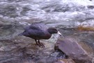
South Island Robin
Photograph
•
Distance: 2.8km away
A South Island Robin - Petroica australis australis
More ▶︎
Matiri Valley to Wangapeka Saddle
GPX file
•
Distance: 2.9km away
An interesting cross country trip in Kahurangi National Park
More ▶︎
Mt. Luna via the stone track
Track
•
3 days. Medium. 19hrs.
•
Distance: 2.9km away
Stone hut is a days march in from the Rolling river, taking the main Wangapeka track.From Stone hut ford the ...
More ▶︎
Matiri Valley to Wangapeka Saddle
Track
•
4 – 6 days. Medium. One way.
•
Distance: 3.0km away
An interesting cross country trip in Kahurangi National Park involving a stretch of unmarked ridge travel
More ▶︎
Siberia Flat campsite
Campsite
•
Basic Campsite (DOC). 40 spaces.
•
Distance: 3.1km away
Camping next to the Wangapeka River near the start of the Wangapeka Track.
Facilities include picnic tables nestled amongst trees ...
More ▶︎
Great place for a snack
Photograph
•
Distance: 3.9km away
Doing my Garfield act on the last day of the Wangapeka
More ▶︎
Wangapeka Track
Track
•
4 – 5 days. Medium. One way.
•
Distance: 3.9km away
A Long gold trail following a series of river valleys.
More ▶︎
Branch Creek Hut
Hut
•
Standard Hut (DOC). Capacity: 6.
•
Distance: 4.0km away
Branch Creek hut
More ▶︎
Chummies Track
Track
•
Medium. Return by the same track.
•
Distance: 4.9km away
Marked tramping track to John Reid Hut and the Arthur Range tops. NB - the start of the track requires ...
More ▶︎
kiwi saddle hut
Photograph
•
Distance: 5.7km away
6 bed doc hut open fire water stunning veiws
More ▶︎
Kings Creek Hut
Photograph
•
Distance: 7.1km away
A large and rather clinical hut on the Wangapeka Track
More ▶︎
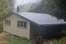
Kings Creek Hut
Hut
•
Serviced Hut (DOC). Capacity: 20.
•
Distance: 7.1km away
A large and clinical 1980s hut on the Wangapeka Track
More ▶︎
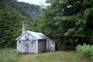
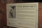
Cecil Kings Hut
Hut
•
Basic Hut/Bivvy (DOC). Capacity: 4.
•
Distance: 7.3km away
This historic hut is only a couple of hundred metres from the newer and larger Kings Creek Hut on the ...
More ▶︎
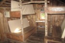
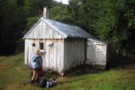
Cecil King Historic Hut
Photograph
•
Distance: 7.3km away
Built from the bush, a reminant from a past era
More ▶︎
John Reid Hut
Hut
•
Standard Hut (DOC). Capacity: 6.
•
Distance: 7.4km away
Standard 6 bunk hut at approx 1240m. Great views to the East from the hut. Climb to the ridge above ...
More ▶︎
John Reid Hut
Photograph
•
Distance: 7.5km away
Standard DOC hut in Kahurangi. Access Via the ridge from Mt. Patriach and Kiwi Saddle Hut or up from the ...
More ▶︎
John Reid Hut
Hut
•
Standard Hut (DOC). Capacity: 6.
•
Distance: 7.5km away
John Reid hut. Standard 6 bunk hut. Water in small stream 20m towards toilet. Superb sunrises!
More ▶︎
Mount Patriarch Tops
Photograph
•
Distance: 7.6km away
Mount Patriarch Tops, Kahurangi National Park.
More ▶︎
Kiwi Saddle Hut (Wangapeka)
Hut
•
Standard Hut (DOC). Capacity: 6.
•
Distance: 9.0km away
Six bunk hut in NZFS style. Tent sites available in clearing around hut. In early January 2007 there were a ...
More ▶︎
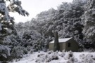
Kiwi Saddle Hut (Wangapeka)
Photograph
•
Distance: 9.6km away
Kiwi Saddle Hut after a light overnight snow.
More ▶︎