Nearby
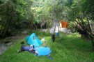
Te Kumi Flat tent camp
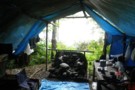
Te Kumi Flat tent camp
Photograph
•
Distance: less than 100m away
A well built, well designed tent camp in the Raukokore on Te Kumi Flat. Sited near north end on the ...
More ▶︎
A Raukumara Crossing
Article
•
Distance: less than 100m away
The first leg of a trip from East Cape to West Cape via the main divide.
More ▶︎
Raukumara East-West Traverse
Track
•
5 – 12 days. Hard. One way.
•
Distance: less than 100m away
An east-west traverse of either the Raukumara range, or the entire East Cape. A minimum of 5-8 days in it's ...
More ▶︎
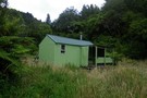
Te Kumi Flat tent camp
Hut
•
Shelter (NA). Capacity: 8.
•
Distance: less than 100m away
A tent camp on Te Kumi Flat in the Raukokore River int he Raukumara Range.
This is a privately built camp, ...
More ▶︎
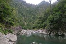
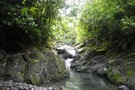
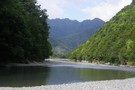
Raukokore River
Photograph
•
Distance: 1.6km away
Pools in the Raukokore a couple of km below Te Kumi Flat.
Access from Te Kumi STation, via the Waikura River.
More ▶︎
Raukumara East-West Crossing
GPX file
•
Distance: 2.0km away
East-West crossing of the Raukumara Ranges. Starting either at East Cape, Te Kumi Station or Mt Hikurangi roadend, and ending ...
More ▶︎
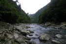
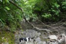
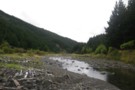
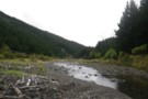
Raukokore River - rapids below Te Kumi
Photograph
•
Distance: 2.3km away
The Raukokore is generally easy going for a tramper from the confluence with the Waikura to Te Kumi Flats. However, ...
More ▶︎
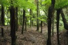
Ohapua Stream
Photograph
•
Distance: 3.4km away
Slow going up the Ohapua Stream - an obvious route from the Raukokore to the Huitatariki
More ▶︎
Te Ranganuiatoi
Photograph
•
Distance: 4.9km away
The ridgeline 500m west of Te Ranganuiatoi at the saddle of the Okapua and Raukokore. We sidled south round the ...
More ▶︎
Huitatariki Headwaters
Photograph
•
Distance: 6.7km away
More scrubby, windfallen, bouldery travel in the upper Huitatariki. 'Boss, can we stop now?'.
The Huitatariki Stream has LINZ riverbed and ...
More ▶︎
Huitatariki campsite
Photograph
•
Distance: 7.6km away
"We're stopping at the first spot of flat ground we find" - exhausted we drop down from Te Ranganuiatoi into ...
More ▶︎
Waikura River below Te Kumi Station
Photograph
•
Distance: 9.2km away
Below the Te Kumi roadend at Te Kumi Station, the Waikura River flows back out of farmland and returns to ...
More ▶︎
Huitatariki River
Photograph
•
Distance: 9.4km away
The Huitatariki open up as soon as it leaves the park, with broad grassy flats and pines of the valleysides. ...
More ▶︎
Huitatariki River
Photograph
•
Distance: 9.4km away
The Huitatariki open up as soon as it leaves the park, with broad grassy flats and pines of the valleysides. ...
More ▶︎