Nearby
Inland Pack Track
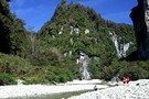
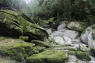
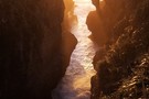
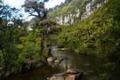
Ballroom, Fox River
Track
•
1 – 2 days. Easy. Return via same track.
•
Distance: less than 100m away
Walk through a spectacular limestone gorge, visit caves, and camp under a massive rock overhang.
More ▶︎
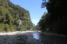
Fox River
Photograph
•
Distance: less than 100m away
The Fox River just downstream from the Ballroom Overhang. This is the route from the end of the track at ...
More ▶︎
Ballroom Overhang
Rock bivouac
•
Distance: 138m away
The Ballroom is an overhanging cliff, carved by a past bend of the Fox River into a a broad curve. ...
More ▶︎

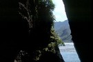
Te Ana o Matuku Cave
Photograph
•
Distance: 416m away
Teorumata Cave at the mouth of the Fox River is carved out of Hawk's Crag breccia.
More ▶︎
Te Ana o Matuku Cave
Track
•
Easy. Return by the same track.
•
Distance: 442m away
An historic cave on the Paparoa National Park coastline.
More ▶︎
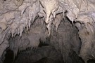
Fox River Caves
Track
•
Easy. Return via same track.
•
Distance: 528m away
Deep caves in the wall of a limestone gorge.
More ▶︎
Cave Creek / Kotihotiho Track
Track
•
Easy. Return by the same track.
•
Distance: 630m away
Scenic walk to the resurgence of Cave Creek.
More ▶︎
Junction of Fox River and Dilemma Creek
Photograph
•
Distance: 1.0km away
The 300m limestone cliffs here are impressive, and Dilemma Creek is quite beautiful. Beyond here, the route to the Ballroom ...
More ▶︎
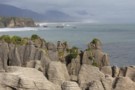
Pancake Rocks
Photograph
•
Distance: 1.2km away
The famous Pancake Rocks at Punakaiki. The alternating layers of limestone and mudstone are formed in a process called stylobedding.
More ▶︎
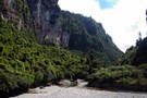
Fox River Gorge
Photograph
•
Distance: 1.3km away
Just below Dilemma jct. Looking downstream to where you get somewhat wet. And Large spiders to eye you up.
More ▶︎
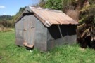
Formerly the Knobby Ridge biv Oct 2011
Photograph
•
Distance: 1.4km away
We saw this biv when emerging from the Inland Pack Track on to the farm track that runs beside the ...
More ▶︎
Former Knobby Ridge Biv
Hut
•
Basic Hut/Bivvy (DOC).
•
Distance: 1.4km away
Originally located on Knobby Ridge, overlooking the Hokitika Gorge, this biv was removed by DOC for a radio base station ...
More ▶︎
Cave Creek
Photograph
•
Distance: 1.5km away
Cave Creek emerges out of the ground and connects up with the Pororari River.
More ▶︎
Dolomite Point Walk
Track
•
Easy. Return via same track.
•
Distance: 1.7km away
The famous Punakaiki Pancake Rocks. Blowholes, sea cliffs.
More ▶︎
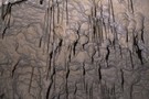
Soda straws, Fox River Cave
Photograph
•
Distance: 1.8km away
A soda straw is left behind by drops of water. Just before the water falls, it forms a hollow shape ...
More ▶︎
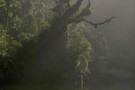
Paparoa National Park
Place
•
National Park. 305.60km2.
•
Distance: 1.9km away
A land of cliffs, gorges, caves, and disappearing rivers, draped in rich coastal forest.
More ▶︎
Pororari River Track
Track
•
Easy. Return via same track.
•
Distance: 1.9km away
An easy stroll along the banks of the beautiful Pororari River.
More ▶︎
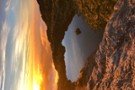
Sunset, Pancake Rocks
Photograph
•
Distance: 2.0km away
The Pancake Rocks are layers of limestone where impurities have separated out into horizontal seams -- a process known as ...
More ▶︎
Paparoa Track
Track
•
3 days. Easy/medium. One way.
•
Distance: 2.0km away
New track located in Paparoa National Park, exploring the Paparoa Range, gold trails and limestone gorges.
Paparoa Track is a dual-use ...
More ▶︎
Pororari River
Photograph
•
Distance: 2.1km away
This river at Punakaiki is popular with canoes, and has an easy walking track.
More ▶︎
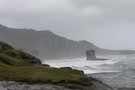
Wild coastline at the end of the Truman Track
Photograph
•
Distance: 3.5km away
The short track passes through coastal podocarp forest, harakeke scrub, coastal herbfields, and down to a sculpted gravel beach.
More ▶︎
Truman Track
Track
•
Easy. Return via same track.
•
Distance: 3.5km away
Visit coastal platforms and caves near Punakaiki.
More ▶︎
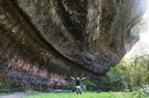
Ballroom overhang
Photograph
•
Distance: 5.4km away
Ballroom overhang on the Fox River, West Coast. between Westport and Punakaiki. great walk in, good track most of the ...
More ▶︎
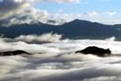
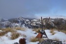
Cloud across Paparoa from camp on Bovis
Photograph
•
Distance: 5.9km away
Oh Tangaroa, what my eyes tell me is that today is another show off day...(Tuwhare)
More ▶︎
View SE from Mt Bovis August 2011
Photograph
•
Distance: 6.8km away
This pic shows the fallen down trig on the summit of Bovis and looks in a south easterly direction toward ...
More ▶︎
Mount Bovis
Track
•
1 day. Medium/hard. Return by the same track.
•
Distance: 6.8km away
Day trip to a 1252m summit off the Paparoa Range behind Bullock Creek farm.
More ▶︎
Mt Bovis
Photograph
•
Distance: 6.8km away
Tarn at 1020m elevation, south of peak
Topomap BS20 coord. 751 359
More ▶︎
Pororari Hut
Hut
•
Great Walks Hut (DOC). Capacity: 20.Bookings required.
•
Distance: 8.3km away
Hut servicing the Paparoa Track, located on a low ridge between the catchments of the Pororari and Punakaiki Rivers.
More ▶︎