Route guide: Scotts Road to North Mangahao Biv
- 1 day return by the same track
- Medium/hard
The northern Tararuas get little of the traffic of the rest of the range. There's an image of an uninterrupted sea of leatherleaf - but this is unfair. Down off the tops there's some great open bush, and the main challenge is more the steepness of the valleysides.
This is a partial guide to the route from Scotts Road to North Mangahao biv. The are two reasons for the lack of completion:
- on the way in I headed for where the biv is shown on the new topo50 maps: I could give you a great guide to how to get there – but unfortunately it’s not where the biv is!)
- on the way out I lost the track and ended up dropping to the Miro River and following that up: not recommended unless you like water and waterfalls. Canyonning down it is, apparently, more fun
Hopefully, I, or someone else, can add the missing second section at some point. However, the instructions here should be enough to point you in the right direction and avoid the mistakes I made.
|
Walking time
|
1 day
3 hr – 9 hr
|
|---|---|
|
Distance
|
9.0km |
|
Type
|
Return by the same track
|
|
Grade
|
Medium/hard
I got lost - so some route-finding skills must be required! Grades explained
|
|
Bookings
|
No bookings — open access
No — open access
|
|
Starts
|
End of Scotts Road, Palmerston North |
|---|---|
|
Ends
|
North Mangahao Biv |
|
Maps
|
NZTopo50-BN34
NZTopo50-BM34 |
|
Altitude
|
320m
–
686m
Altitude change 366m
|
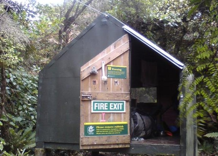
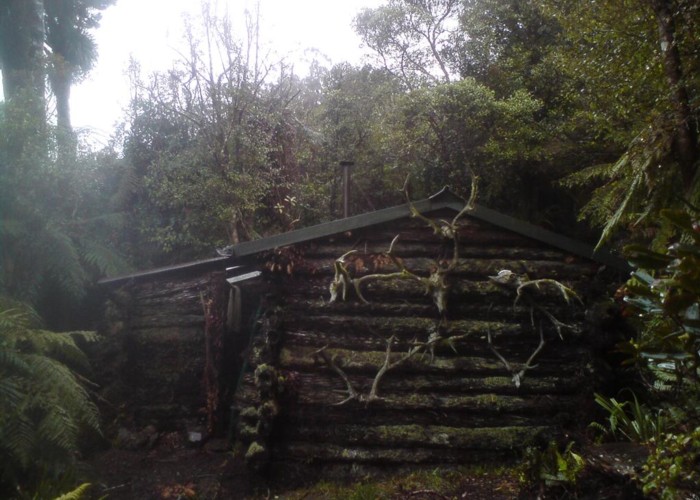
Note: North Mangahao hut is shown incorrectly on many maps, including the Topo50 1st edition (2009). The correct location is BN34 E1820790, N5508771
I've used the names of rivers given in local hut books here - but they are not named on the map. Toko River is the tributary of the Tokomaru which heads WSW from the end of the Albert Road track to Ngawhakarara peak. Miro river is the tributary of the Patupaiarehe which branches off at the eastern bushedge, and head due west to reach a broad saddle with the formentioned Toko at BN34 192093, just south of pt686 on the map. The track described here descends to just east of this saddle
There is a locked gate across the bridge on
Follow the metalled road through the forestry, to where the metalling ends on the map, and the track forks in 3. Ignore the first right to Burton Track, and take the second right up Loop Road. Follow this track to the back boundary of the forestry (BN34 187106) where you'll find a fence with endless thick scrub beyond. There’s no indication of a track, but hop the fence anyway. Push through 50m of waist high tussock angling slightly left along the summit of the ridge to where the thick scrub starts. There’s a cut track here on the ridge summit – the first 5m rather bushy but good beyond that. The point it enters the bush was marked with red flagging tape when I was there.
Once on the track, it’s easy going. The track is well cut, though not marked. After about 300m (halfway to pt686) the track forks. For N.Mangahao Biv, take the left fork.
The right-hand track (straight on) drops first SW then S down the ridge to the middle of the clear area on Toko Creek. It is possible to go this way, then follow the creek up to the saddle – but takes much longer. You can also head down the creek from there to join the
Assuming you took the left fork, the track soon exits the bush and is well cut through thick shoulder-high scrub to pt686. Here it swings due east along the ridge for a further 500m to ‘the rocks’. It then drops steeply down the ridge between the first two creeks draining into the Miro (east-flowing) river. The track is well marked for this descent all the way to the creek, which it crosses before following a small ridge on the far side for a short distance east to a track junction, which you cannot miss.
Saddle (track junction) to
This is were I went wrong. From the junction, I followed the track heading east, across a side creek, then took the first ridge downriver of the track junction. Climbing due south I followed a track marked with pink flagging tape all the way to the summit. This hit the top just east of the point my map shows the Biv to be (halfway between pt749 and pt705). But the biv is not there, and apparently never was. If you end up making the same mistake, bash across the tops to the south-eastern face and drop 100m for some good bush. You can then sidle north-east along the face until you pick up the track from Kopikopiko Road on the first spur north of the ridge from pt705 to pt531. Not the recommended route!
On my return I left North Mangahao Biv, neaded briefly NW to the Miro valley face, sidled west from that point along a track marked with blue flagging tape. After about 400m this track started to head downhill, and I followed it until it disappeared about halfway down the face. Sidling upriver along the valleyside from this point was not possible due to thick scrub, so I had to drop to the river and follow it up. This is possible, but there are 3 moderate sized waterfalls (the largest 20ft high) to pass which require some tough scrambling on steel valleysides.
What you need to find is a track sidling somewhere in between these two options. Both local hut books mention a sidle track – Punga Hut refers to it as a superhighway – which probably means it is cut to the same standard as that from Scott roadend to the saddle. It is not in the lower half of the valleyside, that I can confirm, so it must run higher than I was looking. Unfortunately both ends have a proliferation of flagging-taped routes, most probably the result of posummers who have spent a lot of time here, and finding the right one is the challenge. Once on it, it should be easy!
Both routes I followed took me 4 hours from the locked gate to North Mangahao Biv – that’d be 8 DOC hours. If you find the track, that should be halved easily.