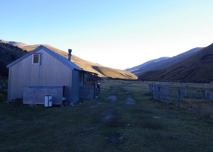
Boundary Creek Hut (Oteake)
Oteake Conservation Park
A recently refurbished 8-bunk hut in the West Branch of the Manuherikia, part of the Oteake Conservation Area which now stretches from near the Danseys Pass to Mt St Bathans. The hut has 8 bunks set around a large central table. There's a coal range, but no firewood so you'll have to bring your own or depend on the supplies of coal at the hut. Tank and creek water are available.
The hut is 8km from the sth end of the 4WD track which crosses the Oteake Park from near St Bathans in Otago to Omarama in Sth Canterbury. 4WD / motorbikes are allowed seasonally (Labour weekend till May) and foot, mountain bike and horses allowed year-round.
One loop option from the hut follows 4WD tracks up either side of Boundary Crk to the 2088m summit of Mt St Bathans. Either return on the opposite side, or dropping to Top Hut further upriver (how many 2000m+ peaks can you mountain bike to?). Another 44km loop takes in both East and West branches of the Manuherikia via Top Hut.
|
Owner
|
Owner: DOC |
|---|---|
|
Category
|
Standard Hut |
|
Sleeps
|
Sleeps 8
8
|
|
Facilities
|
Enclosed wood/coal burner |
|
Water supply
|
Tap or tank water |
|
Getting there
|
Hawkburn Runs Rd (St Bathans): DoC campsite at the roadend -> Manuherikia Forks (3km, .5-1hr) -> Boundary Crk Hut via West Branch (5km, 1-2hrs) Broken Hut Rd Carpark (Omarama): Roadend -> Top Hut (12km, 4wd track via Omarama Saddle) -> Junction Hut (8km, 4wd track) Top Hut (via Mt St Bathans): Here -> Summit (8km, 2-3 hrs, track up ridge sth of creek) -> Top Hut (11km, 2-3 hrs, track down ridge 2.5km NW of summit) Top Hut (via creek): 8km (1.5-3hrs, 4wd track) |
|---|---|
|
Unlocked
|
This hut is unlocked and open to access. |
|
Bookings
|
No bookings — open access
No — open access
|
|
Altitude
|
800m |
|---|---|
|
Mobile phone coverage
|
No coverage |
|
Maps
|
NZTopo50-CB15
|
|
Link
|
www.doc.govt.nz/u...http://www.doc.govt.nz/upload/documents/parks-and-recreation/tracks-and-walks/otago/oteake-conservation-park-brochure.pdf |