
There is a range of good walks around the village and the pass itself. Aside from those listed below, short walks along the more challenging tracks can be very rewarding. There are excellent views of the village just a few minutes up Con's Track, and great views of the Devil's Punchbowl Falls from Scott's Track.

If you are walking to the Pass from the village, allow about 1¼hr. Although there is a walking strip at the roadside near the Pass, there is none near the village. Take the Bridal Veil Track and follow the road from there. It's much safer and no slower!
Arthur's Pass Village Historic Walk: 1hr, very easy
The Historic Walk is a self-guided tour of the village, visiting a series of plaques. Pick up an Historic Walk brochure from the DOC Visitor Centre. It provides a map of the plaques around Arthur's Pass, and associated historical notes.
Coaches first crossed the pass in 1866, working between the railheads at either side of the Pass. The construction of the railway through the Pass was a major project with the 8.5km tunnel under the rugged landscape taking 25 years to complete. Tunnellers' cottages are still visible along the main road.
Since World War I, the pass has come to be a popular recreational area for mountaineering, skiing, and excursions. The national park was gazetted in 1929.
Bridal Veil Track: 45 min, Very easy
From the Punchbowl Road car park at the northern extent of Arthur's Pass village, follow a brief track across gravel to the Bealey Footbridge. Beyond, the Punchbowl Falls Track, Con's Track, and the Bridal Veil Track each head off in different directions. Leading into pretty beech forest, the Bridal Veil Track is wide and gently graded. Tall, straight mountain cedar are a feature of the track, with mountain beech, tanekaha, neinei, and archeria also present.
Soon, the track reaches the Falls lookout. The view of the Falls is abysmal, and no better further on. In fact, I'm not convinced there even were any. Aside from that, this is an exposed but sunny lunch spot, with excellent views up the deep gorge of McGrath Creek, opposite, and kea screeching high overhead.
Steps down, and a bridge spans a damp gully. Beyond, the track levels onto a boardwalked bog, as power wires encroach overhead. Power pylons have been defacing the Pass since 1937. The track passes directly under two of these before dropping to the road.
From here, it is 10 minutes walk to the Bealey Valley car park, and 20 minutes to the Temple Basin Skified car park.
Dobson Nature Walk: 30 minutes, very easy
In any season, this walk is rewarding, with panoramic alpine views, but the summer months of November to February are the best time to see the alpine flowers in bloom. From the Temple Basin Skifield car park, the walk heads toward the nearby summit, marked by the tall stone monument to Arthur Dudley Dobson. The wisp of the Ribbon Falls is visible in the distance on the right. Climbing through inaka, Ranunculus lyallii (great mountain buttercup), hebes, and ribbonwoods, the track veers off after a couple of minutes to cross the road. The alpine garden on this side of the road is punctuated with massive boulders that have tumbled from the tops above. The boardwalked track zigzags onto the hillside, passing an inspired series of wooden benches, before dropping back to the summit memorial. A track to the Otira Valley sets off here. A mountain finder table is located behind the memorial.
Devil's Punchbowl Falls Track: 1 hour return, easy-medium
From the Bealey Bridge junction, the track heads towards the Falls and crosses a bridge over Devil's Punchbowl Creek. Sleepers form steps up the hillside, giving way to an enthusiastic gradient over exposed rock further on. Past a side track to Mount Aicken, the track drops gently to the falls. A sign warns of falling debris, but of course the best views of the falls are from up close.
Actually, there are good, "chocolate-box" views of the Falls as a whole from across the valley on Scott's Track.
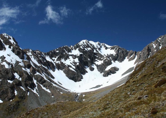
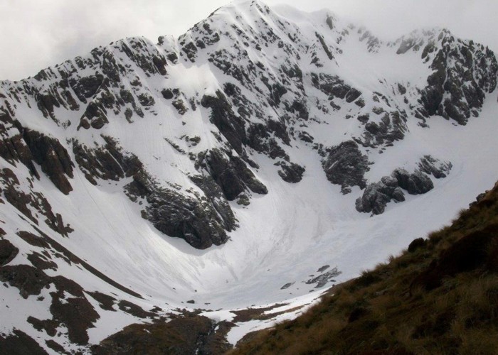
Temple Basin: 3 hours return, easy-medium
This track, winding from the Temple Basin car park up to the skifield, provides access for skiers in winter. In summer, it is a pleasant walk through alpine meadows, with good views across the valley towards Mount Rolleston. Zig-zagging up a spur between Twin and Upper Twin Creeks, the track passes close to one of Twin Creek's waterfalls. The track is persistently steep and rocky.