Summit Walkway
- 2 – 3 days one way
- Easy/medium
- Bookings required
- Gebbies Pass to Packhorse Hut: 2 hours, 5.8km.*
- Packhorse Hut to Mt Herbert / Te Ahu Patiki: 2 hours 15 minutes, 6.5km.
- Mt Herbert / Te Ahu Patiki to Port Levy Saddle: 2 hours, 6km.*
- Port Levy Saddle to Rod Donald Hut: 50 minutes, 2.5km.*
- Rod Donald Hut to Hilltop: 5 hours, 15km.
- Kaituna Valley to Packhorse Hut: 1 hour 20 minutes, 4km.
This track was originally surveyed as part of the Banks Peninsula Summit Road. The physical road was never constructed, but the legal access remains. Farmland and forest reserves, expansive views.
|
Walking time
|
2 – 3 days
11 hr – 14 hr
|
|---|---|
|
Distance
|
35.0km |
|
Type
|
One way
|
|
Grade
|
Easy/medium
Some sections of track are significantly rougher than others. There is easier walking between Port Levy Saddle and Rod Donald Hut and between Gebbies Pass and Packhorse Hut. Grades explained
|
|
Bookings
|
Bookings required
Required
Bookings are required at Rod Donald and Packhorse Huts, but not for walking the track itself.
|
|
Starts
|
Gebbies Pass, Gebbies Pass Road between Teddington and Motukarara. |
|---|---|
|
Ends
|
Hilltop, SH75 (Christchurch Akaroa Road). |
|
Maps
|
NZTopo50-BX24
NZTopo50-BX25 |
|
Altitude
|
160m
–
913m
Altitude change 753m
|
|
Link
|
www.doc.govt.nz/parks-and-recreation/places-to-go/canterbury/places/banks-peninsula-area/things-to-do/summit-walkway/http://www.doc.govt.nz/parks-and-recreation/places-to-go/canterbury/places/banks-peninsula-area/things-to-do/summit-walkway/ |
|---|---|
|
Bookings
|
Access
Year-round access is available from Gebbies Pass to Packhorse Hut and from Hilltop to Rod Donald Hut. However, parts of the track cross private land, and the full track is closed August to 16 October for lambing. Dogs are prohibited. Mountain bikes are allowed on some sections as noted below.
As the two track ends are well apart, you might prefer to walk the track in sections or to split into two parties and swap car keys. Road access is also available at Port Levy Saddle, close to the track's mid-point.
Parking is available at track ends and at Port Levy Saddle. Cars parked at Hilltop Tavern should be left at the far end of the car park.
Walking the track
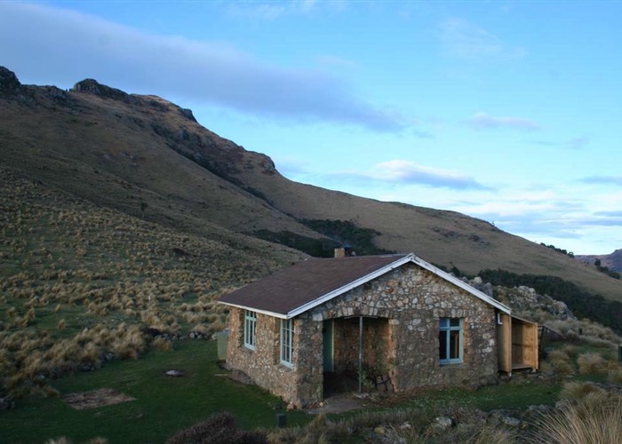
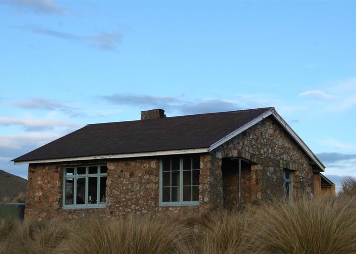
From Gebbies Pass, follow the marked track over farmland and into pine forest. The track breaks out onto a tussock hillside, passing the "Remarkable Dykes" (a pair of hard volcanic walls) and sidling along to the splendid stone Packhorse Hut.
The track climbs around the back of Mount Bradley on a rough track edged by gorse and scrub. The track crosses a fence and follows a farm track to Mount Herbert Shelter near the saddle between Mounts Bradley and Herbert. The track climbs to the summit, the highest point on Banks Peninsula at 919m.
From the summit, the track crosses "Little Mount Herbert" (913m) and passes patches of remnant totara forest. The double-line of fences here highlight the two sides of the unformed legal road. Port Levy Saddle is a striking, handsome spot, crossed by Western Valley Road between Little River and Port Levy.
The track continues on, with a side track to Rod Donald Hut leading off at Waipuna Saddle. This hut is on land owned by the Rod Donald Trust.
From Waipuna Saddle, the track crosses a stark "graveyard" of totara stumps. Most of the forest was cleared for farming, although some reserve pockets remain. The track leads to the head of Montgomery Reserve and a track that drops quickly between cliffs down to Hilltop. On the way, the track passes an impressive 8.5m diameter totara tree. At the road, turn right to head down to Hilltop Tavern.
Walking times
Alternate route:
* Mountain bikes allowed.