Nearby
Godley Head
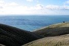
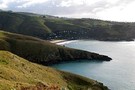
Awaroa/Godley Head Campsite
Campsite
•
Scenic Campsite (DOC). 25 spaces.
•
Distance: 449m away
New campsite located at the mouth of Lyttelton Harbour, next to a WWII defence battery installation.
From the campsite, several ...
More ▶︎
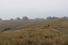
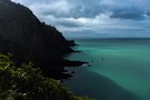
Godley Head
Photograph
•
Distance: 727m away
The WW2 military installations at Godley Head emerge from the fog
More ▶︎
Head to Head Walkway
Track
•
Easy. One way.
•
Distance: 832m away
This track is in development on the shores or Whakaraupo / Lyttelton Harbour. When complete, the walkway is planned to ...
More ▶︎
Crater Rim Walkway: Godley Head to Breeze Col
GPX file
•
Distance: 876m away
First section of the Crater Rim Walkway.
More ▶︎
Christchurch 360 Trail: Godley Cliffs section
GPX file
•
Distance: 1.0km away
Section of the Christchurch 360 Trail, starting at the car park east of Mount Cavendish, Summit Road, Heathcote Valley, Christchurch.
More ▶︎
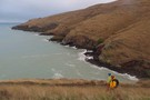
Taylor's Mistake - Godley Head Track
Photograph
•
Distance: 2.0km away
The track is new, wide, easy to follow and scenic
More ▶︎
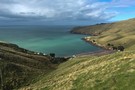
Godley Head Walkway
Track
•
Easy. Loop track.
•
Distance: 2.1km away
A popular coastal walk with sea cliffs and historic military buildings.
More ▶︎
Crater Rim Walkway: Breeze Col to Livingstone Col
GPX file
•
Distance: 2.2km away
Second section of the Crater Rim Walkway.
More ▶︎
Taylor's Mistake - Godley Head
GPX file
•
Distance: 2.5km away
The track from Taylor's Mistake to Godley head has been redeveloped and reopened after the earthquake.
More ▶︎
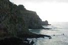
Taylors Mistake
Photograph
•
Distance: 2.7km away
Earthquake-ravaged sea cliffs of Scarborough.
More ▶︎
Taylors Mistake Track
GPX file
•
Distance: 2.8km away
Short coastal walk in a settlement near Christchurch.
More ▶︎
Taylors Mistake Track
GPX file
•
Distance: 2.8km away
Coastal track in the seaside village of Taylors Mistake near Christchurch. Owing to cliff collapse in the February 2011 earthquake, ...
More ▶︎
Scarborough Bluffs to Taylors Mistake
GPX file
•
Distance: 2.8km away
Short walk from the valley behind Sumner in Christchurch.
More ▶︎
Taylors Mistake
Photograph
•
Distance: 3.1km away
Dropping into the tiny settlement from Scarborough Bluffs.
More ▶︎
Christchurch 360 TrailL Estuary Marshes
GPX file
•
Distance: 3.5km away
Section of the Christchurch 360 Trail, starting at the Esplanade near Heberden Avenue, Sumner.
More ▶︎
Captain Thomas Track
GPX file
•
Distance: 4.6km away
Easy climb from Sumner up to the Christchurch Summit Road.
More ▶︎
Waterfall Track, Sumner
GPX file
•
Distance: 4.6km away
Short connector track, with no waterfall.
More ▶︎
Eastenders Track
Track
•
Easy. Return by the same track.
•
Distance: 5.6km away
A short Christchurch walk: climb from Barnett Park up to the Summit Road on the Port Hills.
More ▶︎
Jollies Bush
Track
•
Easy. Loop track.
•
Distance: 5.8km away
A pleasant loop through a pocket of forest above Sumner.
More ▶︎
Chalmers Track
GPX file
•
Distance: 5.8km away
Short climb from Lyttelton up onto the Port Hills.
More ▶︎
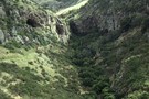
Barnett Park Walkway
Track
•
Easy. Loop track.
•
Distance: 6.0km away
A popular Christchurch walk up a narrow valley to a volcanic cave.
More ▶︎
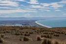
Pegasus Bay
Photograph
•
Distance: 6.0km away
Christchurch and Pegasus Bay from the Crater Rim Walkway, near the Mt Pleasant Bluffs.
More ▶︎
Major Hornbrook / Crater Rim / Chalmers
GPX file
•
Distance: 6.6km away
From Major Hornbrook head at Somes Road, Lyttelton up to Summit Road then across the Crater Rim, down Chalmers Track ...
More ▶︎
Mount Pleasant / Tauhinukorokio
GPX file
•
Distance: 6.6km away
Short walk to the trig on Mount Pleasant / Tauhinukorokio (499m).
More ▶︎
Crater Rim Walkway: Bridle Path to Mount Pleasant
GPX file
•
Distance: 6.7km away
Short section of the Crater Rim Walkway from the top of the Bridle Path, past Mount Cavendish and on to ...
More ▶︎
Christchurch 360 Trail: Sugarloaf Hills
GPX file
•
Distance: 7.1km away
Section of the Christchurch 360 Trail, starting at Withers car park, Halswell Quarry Park, Kennedys Bush Road, Kennedys Bush.
More ▶︎
Bridle Path
GPX file
•
Distance: 7.8km away
Short, sharp historic trail between Christchurch and the port of Lyttelton.
More ▶︎
Stan Helms Track
GPX file
•
Distance: 8.1km away
Short Port Hills climb near the Bridle Path.
More ▶︎
Bridle Path
Track
•
Easy. One way.
•
Distance: 8.2km away
The historic route used by the Canterbury settlers travelling between Lyttelton and Christchurch.
More ▶︎
Crater Rim Walkway: Rapaki Rock to Bridle Path
GPX file
•
Distance: 8.6km away
Short section of Christchurch's Crater Rim Walkway.
More ▶︎
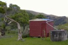
Monument Hut, Banks Peninsula
Hut
•
Basic Hut/Bivvy (NA). Capacity: 8.
•
Distance: 9.8km away
This surprising little hut is a relic of the YHA farm hostel network on Banks Peninsula.
The hut was built ...
More ▶︎
Monument Hut, Banks Peninsula
Photograph
•
Distance: 9.8km away
A small hut near the road on the Purau / Port Levy Saddle.
More ▶︎