Nearby
thay turn up everywhere
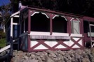
barneys whare
Photograph
•
Distance: less than 100m away
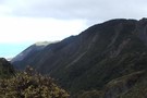
Palliser Bay coast rimuataka ranges
More ▶︎
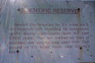
the mesurements show the age of this sign
Photograph
•
Distance: less than 100m away
sign on track at seal colony Palliser Bay coast
More ▶︎
Rimutaka Forest Park
Place
•
Conservation Park. 220.00km2.
•
Distance: 8.0km away
A small block of forest close to Wellington, and abutting Tararua Forest Park. A popular spot for picnics, day walks ...
More ▶︎
Route Guide: Mt Matthews
Article
•
Distance: 8.0km away
Mount Matthews is the closest big peak (941 metres) to Wellington City.
More ▶︎
Mt Matthews
Track
•
1 – 2 days. Medium. Loop with road section.
•
Distance: 8.0km away
A long ridge walk to a fine river valley allowing access to the highest mountain close to Wellington city.
More ▶︎
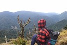
Mt Mathews, Mukamuka stream below
Photograph
•
Distance: 8.7km away
2nd July 2009. Mt Mathews on the saddle looking down onto the Mukamuka stream
More ▶︎

Rimutaka Range
Photograph
•
Distance: 9.2km away
Mt Mathews looking down onto Orongorongo river. July 2009
More ▶︎
Rimutaka Range
Photograph
•
Distance: 9.2km away
Mt Mathews looking down onto Orongorongo river. July 2009
More ▶︎
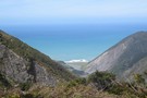
South Saddle Rimutaka Ranges
Photograph
•
Distance: 9.3km away
Looking south from the South Saddle below Mt Matthews.
More ▶︎
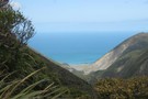
Palliser Bay
Photograph
•
Distance: 9.3km away
Looking east from the South Saddle down the valley to Palliser Bay on the way to Mt Matthews. Mukamuka stream ...
More ▶︎