Nearby
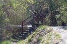
Macetown Road
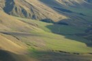
Arrow River
Photograph
•
Distance: less than 100m away
Walking down the Arrow River to Macetown
More ▶︎
Motatapu Track
Track
•
3 days. Medium. One way.
•
Distance: less than 100m away
A new track crossing the tussock tops of the Motatapu and Soho Stations to link Wanaka and Arrowtown, and forming ...
More ▶︎
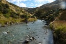
Sawpit Gully Walkway
Photograph
•
Distance: 548m away
This pic is taken about 50m from the trail head at the Bush Creek end. If you start from this ...
More ▶︎
Sawpit Gully Walkway Trail Head - Bush Creek End
Photograph
•
Distance: 548m away
This is the trailhead for the Sawpit Gully Walkway at the Bush Creek end. This pick was taken standing next ...
More ▶︎
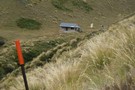
Macetown
Campsite
•
Informal campsite (DOC). 36 spaces.
•
Distance: 1.1km away
Macetown on the Motatapu track. Camping is permitted, but camping or lighting fires in the historic buildings is not permitted.
More ▶︎
Tobin's Track
Track
•
Easy. Return by the same track.
•
Distance: 1.1km away
A short climb onto the Crown Terrace with panoramic views of the Arrow Basin.
More ▶︎
Big Hill & Hayes Creek Trail Head
Photograph
•
Distance: 1.8km away
Trail head for Big Hill track and Hayes Creek track. This is 40 mins from the Bush Creek end of ...
More ▶︎
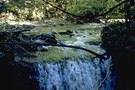
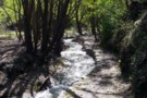
Bush Creek
Track
•
Easy. Return via same track.
•
Distance: 3.3km away
A short, easy walk along an historic creek to a dam at the old Arrowtown water supply intake.
More ▶︎
Hayes Creek Trail
Track
•
1 day. Easy/medium. Loop track with a road section.
•
Distance: 3.9km away
From Arrowtown follow the Sawpit Gully Track (0:40) from the Bush Creek end turn left and climb Big Hill (1:00).
Then ...
More ▶︎
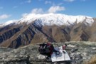
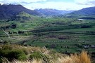
Mt. Soho from Hayes Creek Walkway
Photograph
•
Distance: 4.3km away
50m off the Hayes Creek walkway just near the top of Big Hill.
Mt. Soho is the highest snow capped peak, ...
More ▶︎
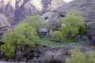
Shamrock Cottage - Hayes Creek
Photograph
•
Distance: 4.5km away
Old mining hut in Hayes Creek called Shamrock Cottage
The hut is locked.
From the signs this is property of Coronet Station ...
More ▶︎
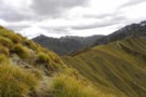
Roses saddle - Motatapu track
Photograph
•
Distance: 6.3km away
The track takes you a little higher than the saddle at 1175m.
It's easy access to the range which separates the ...
More ▶︎

The Motatapu valley from Roses saddle
Photograph
•
Distance: 6.6km away
Down the ridge centre right and on up to here. Roses hut is to the left at the bottom of ...
More ▶︎