Nearby
Lawrence Valley Flats

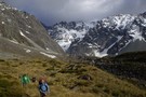
Route Guide: Otira to Mt Cook Village (pt 2)
Track
•
12 – 21 days. Hard. One way.
•
Distance: 1.9km away
One possible route down the main divide from Otira on the Arthur's Pass road to Mt Cook Village.
Otira Hotel ...
More ▶︎
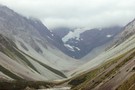
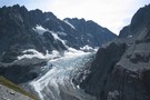
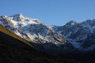
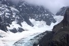
Upper Lawrence Valley
Photograph
•
Distance: 1.9km away
The upper Lawrence Valley and the Lawrence Glacier, from Lawrence Biv.
More ▶︎

Route Guide: Otira to Mt Cook Village (pt 1)
Track
•
12 – 21 days. Hard. One way.
•
Distance: 1.9km away
One possible route down the main divide from Otira on the Arthur's Pass road to Mt Cook Village.
Otira Hotel to ...
More ▶︎
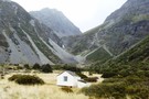
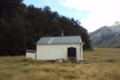
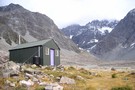
Lawrence Bivouac
Hut
•
Basic Hut/Bivvy (DOC). Capacity: 2.
•
Distance: 1.9km away
Lawrence Bivouac (sleeps 2 on floor, matresses, stream water) is a small but weatherproof bivouac in the upper Lawrence Valley. ...
More ▶︎
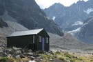
Lawrence Bivouac
Photograph
•
Distance: 1.9km away
Lawrence Bivouac, a small 2-man biv in the upper Lawrence River, Canterbury. The falls at Hells Gates are visible behind.
More ▶︎
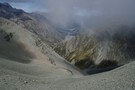
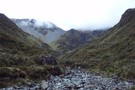
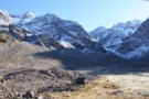
Butler Saddle and the Lawrence Valley
Photograph
•
Distance: 5.8km away
The view down the Lawrence Valley from Butler Saddle. This is an alpine route from The Raikaia into the Lawrence, ...
More ▶︎
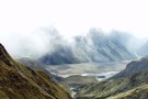
Raikaia from the Butler Saddle
Photograph
•
Distance: 5.8km away
Raikaia River flats, from the Butler Saddle. This is an alpine route from the Raikaia to the Lawrence / Clyde ...
More ▶︎
packrafting trip from upper Rakia to Erewhon Station
Video
•
Distance: 5.9km away
Climbing over Butler Saddle and packrafting down Lawrrence and Clyde Rivers to Erwehon Station in December 2008
More ▶︎
Whitcombe Pass & Butler Saddle
Article
•
Distance: 5.9km away
route guide attached by for Hokitika Gorge to Erewhon via Whitcombe Pass & Butler Saddle. The guide was written by ...
More ▶︎
Lawrence Hut
Photograph
•
Distance: 6.6km away
Lawrence Hut, in the Lawrence River valley, Canterbury
More ▶︎
Crossing the Clyde and Havelock - brushes with the Canterbury Death
Article
•
Distance: 6.6km away
High rivers ... lessons learnt.
Day 11 of the Otira to Mt Cook leg of my Southern Traverse
More ▶︎
Lawrence Hut
Hut
•
Standard Hut (DOC). Capacity: 6.
•
Distance: 6.6km away
Lawrence Hut (6 bunks, matresses, stove, tank water) is a pleasent forestry-style hut on river terraces in the lower reaches ...
More ▶︎
Picton to Aspiring
GPX file
•
Distance: 6.6km away
An aborted alpine traverse. Picton to West Cape, but aborted at Aspiring due to real world emergencies back home. Posted ...
More ▶︎
Cameron Glacier
Photograph
•
Distance: 7.0km away
Cameron Glacier, Arrowsmith Range. taken March 2008.
More ▶︎

Cameron upper valley
Photograph
•
Distance: 7.4km away
The upper Cameron valley showing the Cameron glacier and Arrowsmith range. taken March 2008.
More ▶︎
Lyell Hut
Hut
•
Club hut (Canterbury Mountaineering Club). Capacity: 8.
•
Distance: 7.5km away
This hut is located high on the Rakaia River near the foot of the Lyell Glacier.
More ▶︎
Butler Saddle
Photograph
•
Distance: 7.6km away
Butler Saddle from Reischek Stream. The saddle is the scree-covered col to the left of the ridge in the centre.
More ▶︎
Double Crossing of the Wild Man Brothers Range
Article
•
Distance: 7.7km away
A 3 day trip going from the head of the Cameron River in the Hakatere over the above range to ...
More ▶︎
Cameron river view
Photograph
•
Distance: 8.0km away
The main peaks of the Arrowsmith range, as seen from the middle Cameron valley, 2hrs from the road.
More ▶︎
cameron hut
Photograph
•
Distance: 8.0km away
the peaks above the flats between the moraine walls at the head of the Cameron river, including the Cameron Hut. ...
More ▶︎
Cameron Hut
Photograph
•
Distance: 8.0km away
5-6 hours walking up the Cameron Valley, not far from Lake Heron.
More ▶︎
Wild Mans Brother Range Circuit II
Article
•
Distance: 8.2km away
A longer circuit of the range with a stay in a refurbished musterers' hut in the head of the South ...
More ▶︎
Cameron Hut (Rangitata/Rakaia)
Hut
•
Basic Hut/Bivvy (DOC). Capacity: 9.
•
Distance: 8.4km away
Located close to Arrowsmith Range at the head of the Cameron River valley. This is a Canterbury Mountaineering Club Hut, ...
More ▶︎
Cameron Glacier
Photograph
•
Distance: 8.7km away
Can be viewed an hour or two up behind the Cameron hut.
More ▶︎
Wild Mans Brother circuit
Photograph
•
Distance: 9.1km away
A weekend circuit in former pastoral lease country from the Cameron to the head of the South Ashburton River via ...
More ▶︎