Nearby
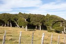
Montgomery Park Scenic Reserve
Montgomery Park Scenic Reserve
Track
•
Easy/medium. Return via same track.
•
Distance: less than 100m away
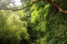
A rich pocket of remnant forest beneath a rocky escarpment on Banks Peninsula.
More ▶︎
Te Ara Pātaka
Track
•
2 – 3 days. Easy/medium. One way.
•
Distance: less than 100m away
This track between Gebbies Pass and Hilltop was once surveyed as part of the Banks Peninsula Summit Road, although never ...
More ▶︎
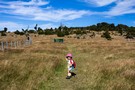
Mt Sinclair
Track
•
Easy. Return via same track.
•
Distance: less than 100m away
An easy walk through native bush and open spaces with great views over Banks Peninsula
More ▶︎
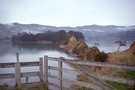
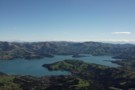
Pigeon Bay
Photograph
•
Distance: less than 100m away
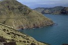
View of Pigeon Bay from track to Mt Sinclair
More ▶︎

Okuti Track
Track
•
Easy/medium. One way.
•
Distance: 767m away
New track over farmland, in Okuti Valley, Banks Peninsula.
More ▶︎
Rod Donald Hut
Photograph
•
Distance: 6.1km away
New hut that servicing Te Ara Pātaka on Banks Peninsula.
More ▶︎
Port Levy Saddle to Rod Donald Hut
GPX file
•
Distance: 6.1km away
Short section of Te Ara Pātaka leading to a new hut. Typical walking time is about 1 hour.
More ▶︎
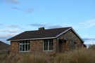
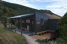
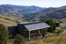
Rod Donald Hut
Hut
•
Serviced Hut (PVT). Capacity: 9.Bookings required.
•
Distance: 6.1km away
Tidy split level hut owned by the Rod Donald Trust and for public use. The hut is located on Te ...
More ▶︎
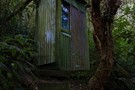
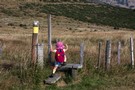
Old toilet, Rod Donald Hut
Photograph
•
Distance: 6.1km away
There is a new toilet, and this is not it. If you like the rustic experience or need a plan ...
More ▶︎
Rod Donald Hut
Photograph
•
Distance: 6.1km away
At night, the view down valley takes in the bright lights of Little River village.
More ▶︎

Down to Rod Donald Hut
Photograph
•
Distance: 6.1km away
Dropping off Waipuna Saddle to the hut. Mount Herbert in the background.
More ▶︎
Onawe
Track
•
Easy. Loop track.
•
Distance: 6.2km away
Historic volcanic peninsula in Akaroa Harbour.
More ▶︎
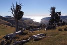
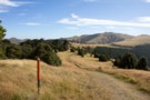
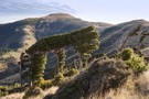
Waipuna Saddle
Photograph
•
Distance: 6.2km away
Wind-shorn tōtara forest and hand-hewn fence posts at Waipuna Saddle.
More ▶︎
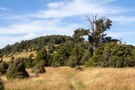
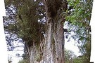
Remnant forest
Photograph
•
Distance: 6.8km away
Pockets of tōtara forest near Port Levy Saddle.
More ▶︎
Christchurch - Little River Rail Trail
Track
•
2 days. Easy. One way.
•
Distance: 7.2km away
Walking and cycling trail along the path of an old railway from Christchurch to Little River.
More ▶︎
Mount Herbert: Western Valley Road approach
Track
•
Easy. Return by the same track.
•
Distance: 7.3km away
A straightforward route along the unconstructed section of the Summit Road to the highest point on Banks Peninsula: Mount Herbert ...
More ▶︎
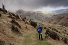
Port Levy Saddle to Mt Herbert
Photograph
•
Distance: 7.3km away
Wind shorn Totara trees beside the ridge track on the way to Mt Herbert - the high point in the ...
More ▶︎
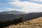
Purple Peak
Photograph
•
Distance: 8.0km away
Stunning view from to top of Purple peak overseeing Akaroa harbour
More ▶︎
Te Oka Reserve Track
Track
•
Easy/medium. One way.
•
Distance: 8.8km away
Descend to some isolated Banks Peninsula beaches.
More ▶︎
Monument Track
Photograph
•
Distance: 9.1km away
Monument Track from the Kaituna Valley side.
More ▶︎
Monument Track (south)
Track
•
Easy. One way.
•
Distance: 9.1km away
Climb from the head of the Kaituna Valley to Te Ara Pātaka, and the network of tracks running from Purau ...
More ▶︎
Monument Track (south)
GPX file
•
Distance: 9.1km away
Short walk at the head of the Kaituna Valley.
More ▶︎
Monument Track (south)
Photograph
•
Distance: 9.6km away
Verdant regeneration on this easy Banks Peninsula walk.
More ▶︎
Pigeon Bay Walkway
Track
•
Easy. Return via same track.
•
Distance: 9.9km away
An easy coastal farmland walk with views back to Christchurch.
More ▶︎