Nearby
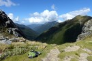
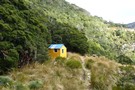
Anatoki Peak campsite
Routes through the Douglas Range
Photograph
•
Distance: 531m away
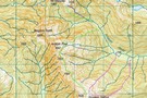
The map shows routes that I have done at various times. Do not attempt the high route in low visibility, ...
More ▶︎
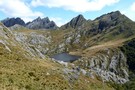
routes from Lonely Lake to Adelaide Tarn
Photograph
•
Distance: 538m away
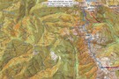
High route marked as blue line
More ▶︎
Lonely Lake to Adelaide Tarn - High Route
Track
•
1 – 2 days. Hard. One way.
•
Distance: 538m away
single day traverse including 2 exposed sections involving non-technical rock climbing or descents dependent on direction of travel
More ▶︎
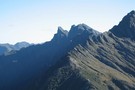
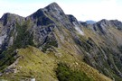
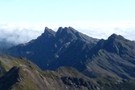
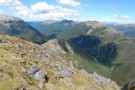
Anatoki Peak etc from Yuletide Ridge
Photograph
•
Distance: 540m away
This photo taken February 2015 is taken from the western end of the summit plateau of Mt Yuletide (1562m). It ...
More ▶︎
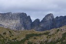
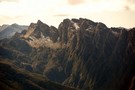
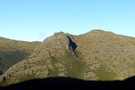
Anatoki Peak
Photograph
•
Distance: 568m away
Taken from SH1270, below Yuletide Peak. Anatoki Peak is mid picture with SH1563 left of centre.
FEB 2017
More ▶︎
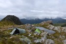
routes from Lonely Lake to Adelaide Tarn
Photograph
•
Distance: 842m away
Our routes marked in pink and another route up to the tarn marked in red which we haven't done. Also ...
More ▶︎
Lonely Lake to Adelaide Tarn - Low Route
Track
•
1 – 2 days. Medium/hard. One way.
•
Distance: 842m away
A single day route from one beautiful lake to another involving travel in the Anatoki river to the saddle south ...
More ▶︎
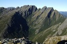
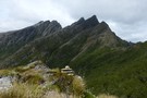
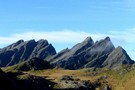
Dragons Teeth
Photograph
•
Distance: 929m away
Dragons Teeth and Anatoki Peak, Douglas Range. Taken from near Lonely Lake, March 2008.
More ▶︎
Lonely Lake and surrounds January 2013
Photograph
•
Distance: 961m away
JH & I ventured up to NW Nelson for a couple of tramping trips in January. A friend from Forest ...
More ▶︎
Dragons Cairn
Photograph
•
Distance: 1.5km away
Above Adelaide Tarn is the cairn that marks the point where the low and high routes separate. The high route ...
More ▶︎
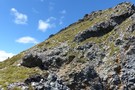
The Needle and the Sidle
Photograph
•
Distance: 1.8km away
With The Needle towering above, the start of the sidle to Adelaide Tarn can be seen left of pic. The ...
More ▶︎
Adelaide tarn hut
Hut
•
Basic Hut/Bivvy (DOC). Capacity: 4.
•
Distance: 1.8km away
Basic 4 bunk hut on the edge of Adelaide Tarn. Surrounded by a series of low peaks (Mt Douglas, Trident ...
More ▶︎
Yuletide Descent
Photograph
•
Distance: 1.9km away
From the summit of Yuletide it's a steep descent to the saddle, and a cairn marking the start of the ...
More ▶︎
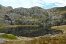
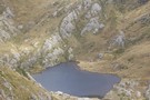
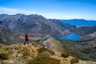
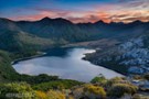
Adelaide Tarn
Photograph
•
Distance: 1.9km away
Taken from our campsite on the TL of the outlet, the hut is right of centre. Only one tent site ...
More ▶︎
Morning Light on The Dragons Teeth
Photograph
•
Distance: 2.0km away
As we climbed out of Adelaide Tarn, wisps of fog cleared to reveal the Teeth. FEB 2017
More ▶︎
The Eye of the Needle
Photograph
•
Distance: 2.1km away
From the saddle below The Needle (and the top of the chute from Yuletide and from Boulder Lake) - looking ...
More ▶︎
Adelaide Tarn
Photograph
•
Distance: 2.1km away
From below the Eye and looking South, The Dragons Teeth and Anatoki Peak pierce the skyline to dramatic effect. Mt ...
More ▶︎
Tarns below Yuletide
Photograph
•
Distance: 2.3km away
The camping is pretty good at the tarns below Yuletide Peak - on a good day - it's quite exposed. ...
More ▶︎
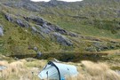
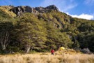
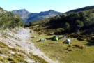
Lonely Lake campsite
Photograph
•
Distance: 2.6km away
on the TR of the outlet are a number of distributed campsites. There are a couple of sites beside the ...
More ▶︎
Dragons Teeth, viewed from the south
Photograph
•
Distance: 2.7km away
The crux of the Anatoki route from Aorere Valley to Cobb Valley. Most people avoid the Dragon's Teeth, and spend ...
More ▶︎
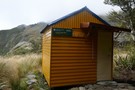
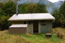
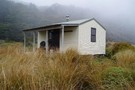
Lonely Lake Hut
Hut
•
Basic Hut/Bivvy (DOC). Capacity: 4.
•
Distance: 2.9km away
Lonely Lake Hut on the Douglas Range was upgraded in 2016 and is now nice and snug with 4 bunks ...
More ▶︎
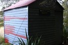
Lonely Lake Hut
Photograph
•
Distance: 2.9km away
We didn't stay here because there are plenty of campsites nearby
More ▶︎
Lonely Lake - Fenella Hut
Track
•
Medium. One way.
•
Distance: 2.9km away
11km route along the Douglas Range from Lonely Lake Hut to Fenella Hut
More ▶︎
Lonely Lake Hut
Photograph
•
Distance: 2.9km away
Lonely Lake Hut on the Douglas Range was upgraded in 2016 and is now nice and snug with 4 bunks ...
More ▶︎
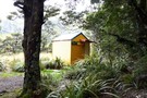
Lonely Lake Hut
Photograph
•
Distance: 2.9km away
the hut is, indeed, in a lovely setting.
The capacity of the hut is 4 people - but 2 would ...
More ▶︎
Lonely Lake Hut
Photograph
•
Distance: 2.9km away
with bench table and a great outlook into the Burgoo in good weather, it can be a dismal place in ...
More ▶︎
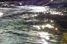
Sparkling Anatoki
Photograph
•
Distance: 5.4km away
The Anatoki River, just up from the Forks, sparkles in the afternoon sun. This is the crossing point for the ...
More ▶︎
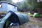
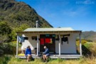
Anatoki Forks Hut
Photograph
•
Distance: 5.6km away
Camping beside the hut - more restricted than it looks as the ground slopes a lot. Still, we managed to ...
More ▶︎
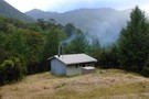
Anatoki Forks Hut
Photograph
•
Distance: 5.6km away
Situated in a clearing, this is a nice sunny place to dry out gear after a storm
More ▶︎
Anatoki Forks Hut
Hut
•
Standard Hut (DOC). Capacity: 6.
•
Distance: 5.6km away
This hut has a HOT SHOWER. yes a fully operational stove with wet back, and it works well, plenty of ...
More ▶︎
Anatoki Forks Hut
Photograph
•
Distance: 5.6km away
In a little clearing near the Anatoki Forks. This makes an ideal refuge from stormy weather
More ▶︎
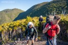
Haupiri Range Traverse, Kahurangi
Article
•
Distance: 6.8km away
Seldom-visited 50km off-track route up Parapara Peak and over the Haupiri Range to Boulder Lake.
More ▶︎
Soper Shelter tent camp
Hut
•
Shelter (DOC). Capacity: 4.
•
Distance: 6.8km away
New reproduction of an old deer culler tent camp. Opened 16/4/2016. Constructed by DoC and volunteers from the Golden Bay ...
More ▶︎
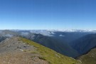
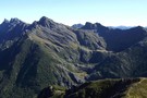
Kakapo Peak
Photograph
•
Distance: 6.9km away
panorama from Kakapo Peak, looking NNW.
The usual route between Fenella & Lonely Lake huts sidles the western scree (mostly) face ...
More ▶︎
Anatoki & The Dragon
Photograph
•
Distance: 6.9km away
The Dragons Teeth, Anatoki and Yuletide Peaks from Kakapo Peak
Mar 2017
More ▶︎
Boulder Lake Hut
Hut
•
Standard Hut (DOC). Capacity: 8.
•
Distance: 7.0km away
Standard DOC hut on the shore of Boulder Lake
More ▶︎
Boulder Lake Hut Mk2
Photograph
•
Distance: 7.0km away
The original hut was built by the Golden Bay Alpine and Tramping Club in 1962.
More ▶︎
Haupiri Range Traverse, Kahurangi
GPX file
•
Distance: 7.0km away
Starting at Ward-Holmes Road, 12km from Takaka, climb up the track to Parapara Peak.
Allow 4-5 days to traverse the remote ...
More ▶︎
On Caesar Knob overlooking Boulder Lake
Photograph
•
Distance: 7.4km away
From the summit of Caesar Knob, the ridgeline down toward Boulder Lake is obvious. However, the lower section is dense ...
More ▶︎
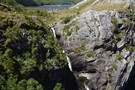
Boulder River waterfall North West Nelson
Photograph
•
Distance: 8.0km away
The photo shows just the top section of a large waterfall on the Boulder River. This waterfall is a short ...
More ▶︎
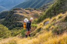
Camping at Paradise Basin
Photograph
•
Distance: 8.1km away
Ample tent space and pure, clear water are available at this remote alpine basin. Listen for weka, kea and goats.
More ▶︎
Jim above Paradise Basin
Photograph
•
Distance: 8.4km away
East of Slate River Peak, descend a grassy slope and rock slide to reach the tarns of Paradise Basin to ...
More ▶︎
Dusk settles over Boulder Lake
Photograph
•
Distance: 8.4km away
Sunset over Boulder Lake looking south to the Dragons Teeth
More ▶︎
Tasman Wilderness Area
Place
•
Wilderness Area. 869.47km2.
•
Distance: 8.5km away
Region of undeveloped remote wilderness in Kahurangi National Park, stretching from the Garibaldi Ridge to the Heaphy River.
More ▶︎
Waingaro Peak
Photograph
•
Distance: 9.3km away
Looking NE to S from the summit of Waingaro, the southerly start of the Douglas Range. Photo shows spur from ...
More ▶︎
Xenicus
Photograph
•
Distance: 9.8km away
morning light on Xenicus from the Lockett Range - clearly visible is the (cairned) rising shelf that leads under Xenicus, ...
More ▶︎
campsite on the Lockett Range
Photograph
•
Distance: 10.0km away
our campsite in the hanging valley on the Lockett range, above Fenella Hut, looking S to Mt Benson. There is ...
More ▶︎