Nearby
Pass Burn Cattle Track
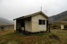
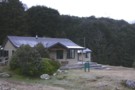
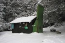
Taipo Hut, Southland
Hut
•
Standard Hut (DOC). Capacity: 8.
•
Distance: 3.7km away
Hut next to the Mararoa River, on the Mavora - Greenstone Walkway.
More ▶︎
Taipo hut
Photograph
•
Distance: 3.7km away
Northern most hut on the Mavora Walkway. Not in 100% condition, there is water damage to the hut floor from ...
More ▶︎
Boyd Creek to The Divide via Kiwi Burn and the Mavora Walkway
Article
•
Distance: 3.7km away
A New Year's trip through the Snowdon Forest and on to The Divide. Heavily affected by weather, I had to ...
More ▶︎
Greenstone Hut
Hut
•
Serviced Hut (DOC). Capacity: 20.
•
Distance: 4.9km away
This hut is built on the site of the old Sly Burn Hut, and replaces the Mid Greenstone Hut. Sly ...
More ▶︎
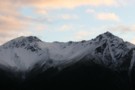
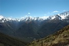
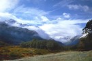
Snow on the Tops
Photograph
•
Distance: 4.9km away
A light snowfall on the tops near the Greenstone hut - April 2009
More ▶︎
Slyburn Hut (Defunct)
Hut
•
Standard Hut (DOC). Capacity: 8.
•
Distance: 4.9km away
This hut on the Greenstone Track has been superceded by the new Greenstone Hut on the same site. The Slyburn ...
More ▶︎
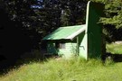
Slip Flat hut
Hut
•
Basic Hut/Bivvy (DOC). Capacity: 3.
•
Distance: 7.0km away
Cute little hut tucked away on Slip Flat in the Greenstone Valley. It is a deer hunting hut but DOC ...
More ▶︎
Greenstone / Caples Tracks
Track
•
4 days. Easy/medium. Loop track.
•
Distance: 7.0km away
The Greenstone and Caples Tracks are often linked together to form a circuit from the shores of Lake Wakatipu. Long ...
More ▶︎
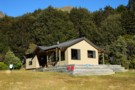
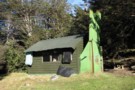
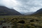
Slip Flat hut
Photograph
•
Distance: 7.0km away
Lovely old-style tramping hut, open fire, bunks, away from the madding crowds.
More ▶︎
Mid Greenstone Hut
Hut
•
Standard Hut (NZDA). Capacity: 16.Bookings required.
•
Distance: 7.1km away
This hut in the Greenstone Valley was managed by DOC, but has since been sold to the New Zealand Deerstalkers ...
More ▶︎
Slip Flat Hut in the snow
Photograph
•
Distance: 7.6km away
Taken in August 2011 on a hunting trip
More ▶︎
Greenstone Track
Track
•
2 – 3 days. Easy. One way.
•
Distance: 8.8km away
A famous, easy track along red tussock river flats.
More ▶︎
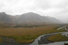
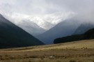
Mavora Walkway Country
Photograph
•
Distance: 9.1km away
Typical country that the Mavora Walkway passes through. Looking south down valley to avoid rain on the camera.
Jan 2014
More ▶︎
steele creek hut
Hut
•
Basic Hut/Bivvy (DOC). Capacity: 3.
•
Distance: 9.4km away
old deer hunters hut. it has got a mud floor and sack bunkings and when i went there the hut ...
More ▶︎
lower Greenstone valley
Photograph
•
Distance: 9.7km away
looking south, near the confluence of Greenstone River and Steele Ck (April 2009)
More ▶︎
lake rere track
Track
•
Easy. Loop track.
•
Distance: 9.8km away
simple half day track aroundlake rere. this is a easy track but no wheel chair access. the lake is cool ...
More ▶︎