Nearby
Pukeiahonoa Track
Raukumara East-West Traverse
Track
•
5 – 12 days. Hard. One way.
•
Distance: 181m away
An east-west traverse of either the Raukumara range, or the entire East Cape. A minimum of 5-8 days in it's ...
More ▶︎
A Raukumara Crossing
Article
•
Distance: 181m away
The first leg of a trip from East Cape to West Cape via the main divide.
More ▶︎
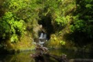
Mangamate Stream
Photograph
•
Distance: 3.1km away
The Mangamate, combined with the Mangakirikiri are the 'official' way into Mangakirikiri Hut on the Motu, though in low flows ...
More ▶︎
Mangakirikiri Stream
Photograph
•
Distance: 4.9km away
The Mangakirikiri Stream, coimbined with the Mangamate is the most common walking route in/out of Mangakirikiri hut (the others being ...
More ▶︎
Raukumara East-West Crossing
GPX file
•
Distance: 5.4km away
East-West crossing of the Raukumara Ranges. Starting either at East Cape, Te Kumi Station or Mt Hikurangi roadend, and ending ...
More ▶︎
Takaputahi Road
Photograph
•
Distance: 5.9km away
This road branches off the Motu Road at Toatoa and provides access to the western side of the Raukumara Forest ...
More ▶︎
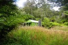
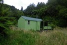
Mangakirikiri Hut
Photograph
•
Distance: 6.0km away
A tidy 6-bunk hut on a high terrace above the Motu - Mangakirikiri confluence. The hut has tank water and ...
More ▶︎
Mangakirikiri Hut
Hut
•
Basic Hut/Bivvy (DOC). Capacity: 6.
•
Distance: 6.0km away
A tidy 6-bunk hut on a high terrace above the Motu - Mangakirikiri confluence. The hut has tank water and ...
More ▶︎
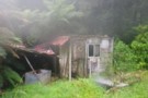
Tukauki Hut, Motu River
Photograph
•
Distance: 8.9km away
I honestly don't know the real name of this hut, but it's opposite Tukauki peak in the Motu (on the ...
More ▶︎
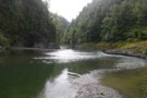
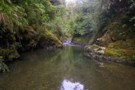
Motu River
Photograph
•
Distance: 9.9km away
The Motu river a few km below Mangakirikiri Hut. Deep, and wide. But beautiful. Part of the east-west Raukumara crossing, ...
More ▶︎