Nearby
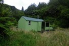
Te Kahika Hut (site)
A Raukumara Crossing
Article
•
Distance: 718m away
The first leg of a trip from East Cape to West Cape via the main divide.
More ▶︎
Raukumara East-West Traverse
Track
•
5 – 12 days. Hard. One way.
•
Distance: 718m away
An east-west traverse of either the Raukumara range, or the entire East Cape. A minimum of 5-8 days in it's ...
More ▶︎
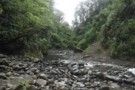
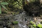
The Big Unknown
Photograph
•
Distance: 1.8km away
A tributary of Te Kahika Stream, this creek provides access to a low saddle into the Motu, bypassing rapids above ...
More ▶︎
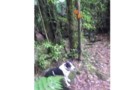
Big Unknown - Motu Saddle.
Photograph
•
Distance: 3.1km away
The only actual track on the Raukumara east-west crossing. Starts somewhere on the face climbing out of The Big Unknown, ...
More ▶︎
Raukumara East-West Crossing
GPX file
•
Distance: 4.1km away
East-West crossing of the Raukumara Ranges. Starting either at East Cape, Te Kumi Station or Mt Hikurangi roadend, and ending ...
More ▶︎
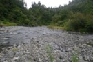
Waihunga Stream
Photograph
•
Distance: 5.0km away
The Waihunga forms part of the east-west route through the Raukumaras. For the most part it's an open valley with ...
More ▶︎
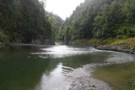
Motu River
Photograph
•
Distance: 6.0km away
The Motu river a few km below Mangakirikiri Hut. Deep, and wide. But beautiful. Part of the east-west Raukumara crossing, ...
More ▶︎
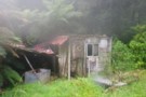
Tukauki Hut, Motu River
Photograph
•
Distance: 7.1km away
I honestly don't know the real name of this hut, but it's opposite Tukauki peak in the Motu (on the ...
More ▶︎
Mangatutara - Waihunga 'track'
Photograph
•
Distance: 9.5km away
The track linking the Mangatutara and Waihunga valleys in the Raukumaras does not exist. Instead you crawl / bash / ...
More ▶︎