The high part of the route is the 4 hours between the well-appointed Powell and Jumbo Huts. It can be done in a weekend but is best spread over three days: one to climb to either hut (usually Powell Hut), another to cross between the huts and the last to loop back to the road end. Powell Hut is one of the better huts in the Tararuas. It is big (sleeps over 30), well constructed and has great faculties - gas heating, gas cookers and probably the best long drops (toilets) in the park. There are great views from its veranda out over the Wairarapa Plains. At night the lights of Masterton are a feature of the landscape. Jumbo Hut is slightly more basic (sleeps 24) but the views are at least as good.
To Powell Hut
The track to Powell Hut and Mt. Holdsworth (1470m) starts at the carpark at the end of the Mt. Holdsworth Road. Pass through the kissing gates and follow the vehicle track up beside the Atiwhakatu Stream for about 100 metres until you come to the Holdsworth Lodge. This hut can be booked at the caretakers house back at the carpark but is open during the day. There is an intentions book in its foyer.
The track continues past the lodge and crosses the Atiwhakatu Stream on a big sturdy footbridge. Just on the other side there is a turn-off up to a forest lookout (1 hour away) and a large sign with the times to various huts (Powell Hut 4 hours).
Follow the wide track straight on until a junction is reached (about 10 minutes). There is a bench here - good for resting weary feet on the way down. If you followed the track straight on then Donnelly Flat is soon reached. This was the site of a gold claim by Fred Chapman and Tom Donnelly during 1906 to 1907. Chapman pulled out during the first year and Donnelly has the dubious distinction of being the first known European casualty in the Tararuas when he died of exposure following a fall on Mt. Holdsworth in 1907. No commercial quality gold has been found in the Tararuas (a few traces were found in quartz reefs).
From the flats, a interesting track (the Loop Track) can be taken over a river terrace and through stands of large trees back to the route. Also departing from here is the route upstream first along a good level track to Atiwhakatu Hut and then steeply uphill to Jumbo Hut.
Take the left turn at the junction instead and hike along a nice bushy track - the Gentle Annie track. This is quite level until it meets the Loop Track (from Donnelly Flat) on the right. From there it starts a long steady climb up above a creek and generally below the ridgeline on the left. There are some nice steps to help you up the few steep parts. After climbing 120m (over 700 metres walking), the track crosses the headwaters of the creek and starts sidling over ridges in a westerly direction.
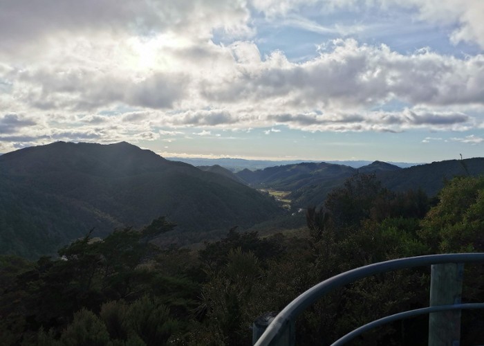
There are some small ridges to cross with a total climb of 80m (easy walking). Around the last ridgeline the track turns sharply uphill through low-lying scrub to a side-track to Rocky Lookout - a large, 3 metre high rock on the ridge crest. This is well worth the minute it takes to get to the rock and its sharp top. There is a clear view up the Atiwhakatu Valley to the clear top of Baldy with the high range containing Jumbo and Mt. Holdsworth forming the valley's west wall and a lower bush covered range on the east.
If you look carefully to the NW then Powell Hut can be seen on the ridge leading up to Mt. Holdsworth. On a fine day, the sun can be seen gleaming on the roof of Jumbo Hut (look down the ridge falling east from Jumbo).
Drag yourself away from the view and and hike along the track for 40 minutes to another junction (about 2.5 hours from Holdsworth Lodge). The track to your left drops down the ridge into Totara Creek and eventually gets to Totara Flats Hut in the Waiohine Valley - part of the popular Holdsworth to Kaitoke walk. Straight ahead the track takes you gently uphill through thinning bush until it breaks out onto Pig Flat (just short of 800m high). There is a little alcove to one side that you can use to inspect the steep ridge up to Powell Hut without blocking the track. This also gives a glimpse into the Waiohine Valley with Totara Flats spreading out beside the river.
Pig Flat is about 500 metres across. It is covered with sub-alpine scrub - the result of a pre-European fire - which is regenerating back to mature bush. The track crosses much of it on a boardwalk to protect the delicate ground. At the end of the flat there is a short descent before an eroded side track is reached (signposted). If you head straight on for a little further there is another junction with signposts marking the alternative route out along a steeper and rougher track straight down to the Akiwhakatu Stream. The site of the old Mountain House Hut is a couple of minutes to the left from the second junction.
The first junction drops down an eroded section reaching a saddle in about 50 metres. The saddle is the site of the original Mountain House and the clearing now is often used to drop supplies from helicopters for track maintenance. It also contains the new (as of 2003) Mountain House Shelter.
The new track starts at the other side of the saddle and climbs up the side of the ridge - initially quite steeply. The old track took the direct route straight up the steepest slope of the ridge (it is now extremely eroded). The gradient of the new track soon eases and it climbs steadily along the ins and outs of the ridge. An advantage of this route is the chance of views into the Tauherenikau Valley through the large trees at track-side.
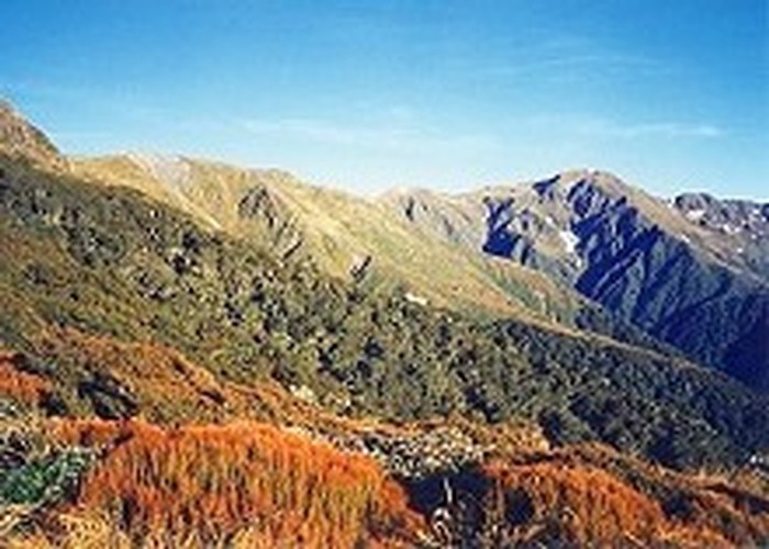
After about half an hour you come across a small pond and then the track rises up onto the ridge crest and joins the old track. This leads through a mixture of rimu and kamahi bush with plenty of scrambling over tree roots. An hour of hiking takes you to a small dip before a steep climb up a bank. At the top of the bank, the track turns to hike along a narrow ridge and then climb out to the Sentinel - a rocky outcrop with clear views. The outcrop is named not only for its good views but because the best known of the Tararua surveyors, Morgan Carkeek, had a camp (starting from 1865) nearby where he waited for clear weather before proceeding to the summit. The gully on the other side of the Sentinel is the headwaters of Totara Creek with the slips on the far side rising to High Ridge (a route sometimes used to and from Totara Flats).
The track continues up the ridge, sometimes through tussocky clearings and other times through patches of bush. In some places the track is quite rough - there are big steps to clamber up and rocky patches that are tricky in icy conditions. In 20 minutes you get to the top of a rocky clamber and Powell Hut reveals itself, tucked into its niche in the tussocky slopes ahead.
My recommendation for day trippers and people staying the night is to drop your packs at the hut, have a brew for afternoon tea and then continue upwards (weather permitting) to Mt. Holdsworth. The track is a bit steep for the first quarter of an hour until it meets the junction with High Ridge but is fairly easy going from there on. Expect to take an hour up to the summit and a lot less coming down. The sturdy trig station beacon can be seen drawing nearer from about the halfway point. From Mt. Holdsworth, there is a magnificent panorama from Angle Knob, McGregor (peeking above Angle Knob) and Mitre Peak (just visible above Jumbo) to the north and along the Main Range to Mt. Hector in the south. A nice option is to observe the sunset from the summit. A more comfortable option is to watch the sun set from the hut's porch.
To Jumbo Hut and out
Return to the top of Mt. Holdsworth the next day for some morning views. The turn-off along the ridge to Jumbo is signposted about 20 metres before the summit. The track heads steeply downhill to the east, shedding nearly 60 metres in the next 100 metres travelled. At the bottom of the drop the track swings to the north and climbs past a small tarn to the bumps of East Holdsworth (1420m).
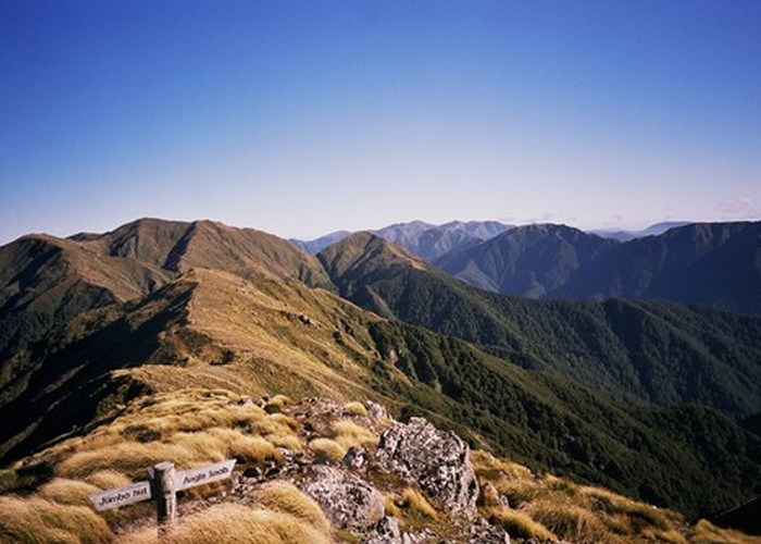
The track drops 150 metres over the next kilometre to a cleft saddle containing a triplet of tarns. This is followed by a climb up to point 1367. Another dip down to 1300m is traversed before the sturdy signpost on Jumbo (1405m) is reached. You should get to Jumbo about 3 hours from Powell Hut - an hour to Mt. Holdsworth and then 2 hours across the tussock tops. The summit is a good spot for a lunch break but Jumbo Hut is only 40 minutes away and downhill all the way. This hut replaced an older hut that was sited along the ridge to Angle Knob until it was blown away by a storm.
People who have decided to stretch the trip into three days have a great chance to further explore the tussock with a side-trip to Angle Knob (2 hours return) or even McGregor (add another 70 minutes). The route to Angle Knob curves to the NW on a narrow crest above a necklace of tarns . At point 1397, the route heads resolutely to the NW and climbs steadily to Angle Knob at 1510m. The rounded summit of McGregor is only 35 minutes away, at first to the north and then NE. Another good option for fit and experienced parties is to go further west from Angle Knob to Shingle Slip Knob and the remains of an aircraft wreck (no track, some steep terrain). Take care at one point on the return journey. The track vanishes into a rut through the tussock about 750 metres from the knob with a clear ridge heading to the NE - it is easy to miss the rut and head down the ridge.
The track from Jumbo down to Jumbo Hut drops sharply over rocky ground at first and then re-enters the tussock. A sign that the hut is nearing is the easing of the slope and a better path. The hut is revealed tucked up against the slopes as the track swings around an embankment. There are usually grand views from the hut out into the Wairarapa plains over the green hills, Just above the hut, there are clear vistas back up to the high ridges - Angle Knob, McGregor, the Three Kings and Baldy being prominent.
The Raingauge Spur track leaves from the south end of the hut and leads onto the next spur to the south. Here it enters the bush beside some isolated beech trees about 10 minutes from the hut. There is a steady descent through some good bush all the way to the Atiwhakatu Stream (and hut). A large clearing appears about halfway along the track (45 minutes from the hut) which is crossed and left by its lower end. I believe that this clearing used to contain the raingauge for which this spur is named. The small Atiwhakatu Hut is reached after 90 minutes and is a good spot for a morning break with the nearby stream providing good water.
The track to the Holdsworth Road leaves from in front of the hut. This is a wide (except where it crosses one small slip), mostly gravelled and level track. All the major side-streams are bridged - one with a tree. There are nice views back up the valley from the clearer sections above the minor gorge before Donnelly Flat. Once back at Holdsworth Lodge you can relax with a hot drink - the lodge has a Zip water boiler. In warmer weather, you can buy a can of drink or chocolate bar from a machine at the caretakers house.