Iron Whare
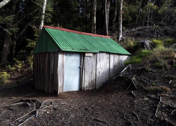
Iron Whare is a 2-bunk historic hut cut into the hillside where the plateau narrows to a ridge below Kaweka Flats. The hut was built in the 1870s from hand-sawn timber walls with iron roofing. The rear wall appears to be made of flattened packaging tins - though these look fairly new, so are presumably replacements for the originals. The hut was renovated in the renovation of the early 2000s. Old photos show an entrance porch, which is now gone. There was also, apparently, once a sod-built fireplace and chimney, now also absent.
Despite its historic nature, this is still a functional 2-bunk hut. There are no mattresses. Probably more of an issue is the lack of water - there is none at the hut site, and the map shows the nearest stream to be 40 vertical meters below the hut. However, it seems likely there is water somewhere closer, it you can find it.
The long-drop is about 100m away down the ridge: the wall-less, roof-less box-with-a-hole variety.
|
Owner
|
Owner: DOC |
|---|---|
|
Category
|
Basic Hut/Bivvy |
|
Sleeps
|
Sleeps 2
2
|
|
Facilities
|
Toilet |
|
Water supply
|
No water |
|
Getting there
|
Kaweka Flats Biv: A cut, marked, signposted DOC track forks off the Kaweka Flats - Middle Hill track 1km north of Kaweka Flats Biv and follows the escarpment to the Hut. Whittle Road (reservoir): A well travelled route follows an old benched track / road down the ridge from the hut before dropping south to the stream and climbing a long slip to meet Whittle Road (the Kaweka Forest access road) at the reservoir/fire dam west of pt1083. See related info for details |
|---|---|
|
Unlocked
|
This hut is unlocked and open to access. |
|
Bookings
|
No bookings — open access
No — open access
|
|
Altitude
|
900m |
|---|---|
|
Mobile phone coverage
|
No coverage |
|
Maps
|
NZTopo50-BJ37
|