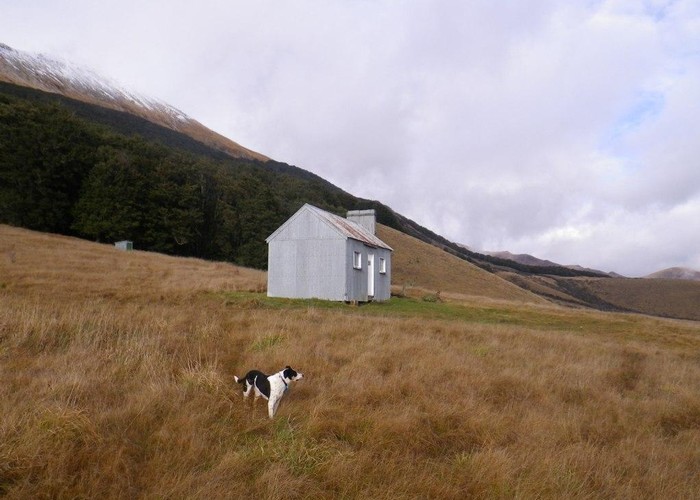
Upper Oreti Hut
Eyre Mountains/Taka Rā Haka Conservation Park
A historic musterer's hut at the nth end of the Oreti valley in the Eyre Mountains. The hut has 6 bunks and an open fire. It's a large hut and despite it's 'historic' status is still well used and comfortable.
A 4WD track runs down the Oteri River flats from the Oreti bridge on the Mt Nicholas Road to Oreti Road north of Mossburn. 4WD access is restricted (contact DOC Invercargill for details) but foot and mountain bike access is allowed at all times. For people biking south from Mt Nicholas Station off the TSS Earnslaw this valley is much more pleasant going than the loose gravel and traffic on the Mavora Lakes Road. 2 huts lie on this route, Upper Oreti and Liverpool. Oreti Hut, further south is not on this road
The ridge upriver of the hut leads to pt1330 from where it is a simple descent to Ashton hut - the main access route to Ashton. Upper Windley is accessible over pt1601 via this ridge - a lower 1400m pass is another option from Lincoln Hut downriver
|
Owner
|
Owner: DOC |
|---|---|
|
Category
|
Basic Hut/Bivvy |
|
Sleeps
|
Sleeps 6
6
|
|
Facilities
|
Open fireplace |
|
Water supply
|
Tap or tank water |
|
Getting there
|
Mt Nicholas Rd, (Oreti Bridge): 6km (1-2hrs), 4wd track. Crossing of Ashton Burn can be a problem after heavy rain. Oreti Road: 13km, 4wd track: Crossing of Oreti River required. Lincoln Hut: 3km, 4wd track: 2km down river and take track on left leading towards a large clearing. Hut inside bushedge. Not shown on new topo50 map series. Ashton Hut: 5.5km (2.5-5hrs), route. Climb next ridge north of hut to pt1330 then descend to hut. |
|---|---|
|
Unlocked
|
This hut is unlocked and open to access. |
|
Bookings
|
No bookings — open access
No — open access
|
|
Altitude
|
580m |
|---|---|
|
Mobile phone coverage
|
No coverage |
|
Maps
|
NZTopo50-CD09
|