Maropea Forks Hut
Ruahine Forest Park
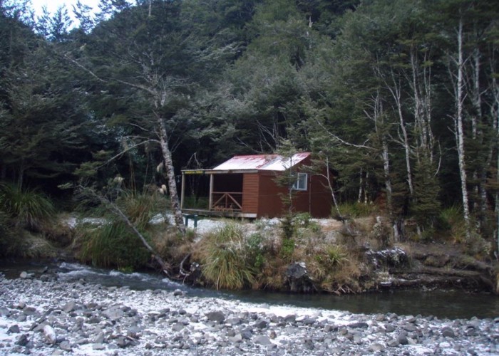
Maropea Forks Hut is a typical forestry style 6-bunker on flats near the forks of the North and South Maropea River in the Ruahine Ranges. The hut's on the true left, about 200m up the northern fork from the confluence. It manages to sit on the opposite bank of the two creeks from all of the 3 tracks which converge here - quite an achievement. Appreciate those wet socks and boots in the evening, because they'll be just as wet by the time you've left in the morning. From hut book accounts, crossing the southern fork is the main difficulty in high river levels.
The Ruahine special 'Corker Cooker' wood-burning stove provides heat and an option for cooking: great to heat up the hut and cook on, if you have the patience to cut wood small enough to fit. There's no way of damping it down so no good keeping hut warm all night - but hey: that's what the sleeping bags for, right?
Water comes from the creek 10m from the hut. A large covered veranda completes the picture.
|
Owner
|
Owner: DOC |
|---|---|
|
Category
|
Standard Hut |
|
Sleeps
|
Sleeps 6
6
|
|
Facilities
|
Toilet, Enclosed wood/coal burner |
|
Water supply
|
Tap or tank water |
|
Getting there
|
Mokai & Kawatau roadends: 16km routes over Mokai Patea via Otukota hut. Other track via Mokai Hut is private Wakelings Hut: 5km (2-4hrs) track Otukota Hut: 7.5km (time unknown) track Colenso Hut: -> Unknown Campsite 6km (2-4hrs) -> Colenso Hut 4km, (2-4 hrs) tracks, 400m of riverbed route Top Maropea Hut: 7.5km (time unknown) riverbed route & track to hut Main Ruahine Range (Maropea Pk): 3km (time unknown) riverbed route & track to tops |
|---|---|
|
Unlocked
|
This hut is unlocked and open to access. |
|
Bookings
|
No bookings — open access
No — open access
|
|
Altitude
|
820m |
|---|---|
|
Mobile phone coverage
|
No coverage |
|
Maps
|
NZTopo50-BK36
|