
This is one of those tramps which is a must-do for any keen tramper or hiker visiting the Hawke's Bay, with a day or two to spare. It can be done as a day tramp for the reasonably fit, or as a comfortable overnight tramp, if time permits. It does, however, require good weather, so check the forecasts before starting off. Wet feet are guaranteed though, as this walk incorporates numerous river crossings. Time wise, allow for three hours one way, or six hours for the round trip, walking time.
The start is from the carpark at the end of Wakarara Road, turning west (towards the mountains) off State Highway 50 in the Central Hawke's Bay district. Allow for a drive of about 45 minutes from either Waipukurau or Waipawa, or up to 1.5 hours from Napier or Hastings.
There is an information board at the start, with some interesting details about the area and it's history. Just before the carpark you'll have driven past an old, rusty boiler, which hints at the area's timber milling past. There used to be a fair-sized settlement here, which only lasted as long as the available timber.
There is no track as such - it's straight into the river, turn left, and keep going upstream until you get to the hut. The riverbed at the start comprises wide, expansive gravel, pebble and boulder flats, criss-crossed by the various channels cut by the river, and I suppose the Makaroro could be described as a North Island example of a braided river system. The scenery is intially quite interesting and varied, being comprised of steep-sided bluffs, farmland, bush and forest plantations. After about an hour's walk, you'll arrive at the confluence with Gold Creek, coming in from the left. You'll note some orange triangles here on both banks, one which indicates the track up to Gold Creek hut, and the other indicating an alternative return route through plantation forest (neither covered by this article). At this point, farmland dissappears, the valley narrows appreciably, and a sense of being in the wilderness quickly takes over. The river is a delight to walk through or in, and is seldom difficult to cross during normal flow. There are some large pools of crystal clear, blue-tinged water to have a dip in, and on a hot summer's day, a very refreshing must-do! There are also plenty of great spots to take a rest stop, but keep an eye out for sandflies - not nearly as bad as the South Island variety, but plentyful nevertheless!
After about an hour and 50 minutes from the start, you'll get to what is, in my opinion, the only difficult crossing. The river here flows strongly through a narrow slot, and while crossing it may look easy to start with, closer inspection reveals that the water is waist-deep, and that it is not as easy as it looks. Those with long legs could probably boulder-hop across (strongly discouraged!), or a safer way is to plunge in, inch your way along the rocks on the true right for about 5 metres, and then cross. As the flow here is still quite strong, think twice before attempting this unless you have the support of a walking pole or stick. The safest option is to bactrack down the true right bank for about 50 metres, cross to the opposite side, and scramble up the bank to a small gap in the bush. This looks more difficult than it is, but if one person climbs up first and hauls up the packs and helps the others up, it should not be a problem. From this point there is a short, clearly defined track on the true left bank which deposits you safely back in the river on the upstream side of the slot.
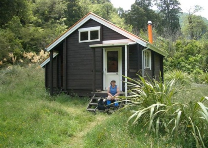
About two hours from the start you'll reach the start of the track up Colenso Spur on the true right bank, just after passing another small stream on the left. Ignore this, and continue upstream for about 15 minutes, when you'll arrive at the site of a giant slip (or landslide) on the true left bank. The size of this one is positively awe-inspiring, and the mind boggles at the quantity of material that must have fallen into the river at this point. By now you'll also have noticed that the river has narrowed appreciably, and the going has become a little less easy, as walking is mostly on the bouldery banks. There is another sizable slip about 20 minutes further upstream, but not as impressive as the first. From here it's about another 10 minutes walk upstream before you'll see the orange chimney of Barlow Hut on the true right bank. A short scramble up the bank brings you to the hut, which is a comfortable Lockwood-style affair, with sleeping platforms (with mattresses) & space for 10 persons, a covered back porch with woodbin and back door into the hut, and a woodburning stove. There is some space for camping around the hut if it is full. There is no water tank - the river is close by, and always full!
For the return trip, retrace your steps to the start - it's surprising how different the scenery looks going the other way. One tip - before starting this walk, identify a landmark at the start where you enter the river, as it's very easy to walk right past it on the way back - I almost did! I'd also recommend taking sunscreen, a hat, and insect repellent.
Conclusion - this is a cracker of a tramp, which I'd recommend very highly. If you're coming from further afield than Napier or Palmerston North, there are some nice, reasonably-priced motels, cafes and watering holes in Waipukurau/Waipawa, as well as two shops which stock most tramping requirements. There are also some local boutique vineyards worth a visit, as is the DOC field centre and General Store in Onga Onga historic village.
Maps - you'll need two - series 260 topomaps U21 Kereru and U22 Ongaonga.