Big River - Inangahua Track
Victoria Forest Park
- 6 hr – 7 hr one way
- Medium
- Inangahua Swingbridge to Inangahua River Ford: 1 hour
- Inangahua River Ford to Golden Lead Battery: 2.5 hours
- Golden Lead Battery to Big River: 3.5 hours
- Big River Track to Waiuta: 3.5 hours
- Reefton - Big River 4WD Road: 7-8 hours
- Big River - Rainy Creek route: 5.5 hours
- Big River Dam short walk: 1 hour 40 minutes return
Faded gold miners' trails into the remains of the Big River gold town, past old stamper batteries, rails, mines and buildings.
|
Walking time
|
1 day
6 hr – 7 hr
|
|---|---|
|
Distance
|
10.0km |
|
Type
|
One way
|
|
Grade
|
Medium |
|
Bookings
|
No bookings — open access
No — open access
|
|
Starts
|
Inangahua Swingbridge car park, SH7 south of Reefton |
|---|---|
|
Ends
|
Big River |
|
Maps
|
NZTopo50-BT21
|
|
Altitude
|
240m
–
820m
Altitude change 580m
|
Big River is a classic goldmining ghost town tucked into the forested ranges of Victoria Forest Park. There are several routes in, with the easiest being via Waiuta. This route leads in from the Inangahua Swingbridge and explores some mining sites along the way. A good hut overlooks the old town site, and regularly accommodates mountain bikers, 4WDers, motorcyclists, horse parties, as well as walkers. Allow some time to explore the area.
Access
Eleven kilometres south of Reefton on State Highway 7 a bridge crosses Rough or Tobin Stream (labelled, nevertheless, as "Branch Stream" on the bridge itself). Immediately north of this bridge a small road is signposted, giving access to the Inangahua Swingbridge. Follow it to a pretty picnic area and bridge over the deep brown water.
Inangahua Swingbridge to Inangahua River Ford
Cross the bridge and follow a well-maintained track up stairs and alongside the old dry Progress Water Race. Tunnels can be seen passing through small spurs, and old timbers are visible where once small gullies were bridged. A series of long staircases drop into and back out of side-creeks, but the walking is easy. Drop down to the Inangahua River to pass a signposted ford back to the highway.
Inangahua River Ford to Golden Lead Battery
The track from here is rougher, and all the old bridges have been knocked down, resulting in awkward scrambles. Along Deep Creek it is easier and quicker to drop down to the riverbed than to follow the track, which struggles along the valley well above the river and has slipped magnificently at one point. Eventually the valley flattens out and the track crosses the Cumberland Battery site, where there is little to see. A swingbridge crosses Deep Creek near here. If you have been following the riverbed, regain the track at this point.
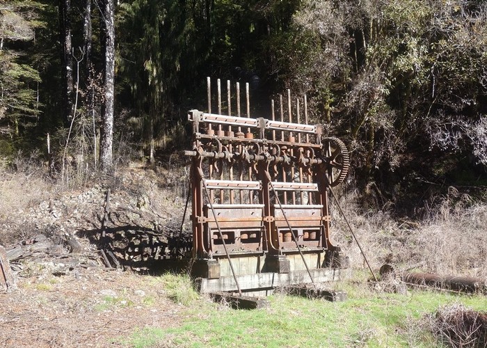
Fifteen minutes further on, a new wooden bridge crosses Golden Lead Creek over to the Golden Lead Battery, an excellent lunch stop (there's even a picnic table!). This battery is one of the best preserved in the region. The Golden Lead Mine is on the Big River Road on the hillside opposite and was once connected to this site by a cableway. Quartz was crushed here to extract the gold. A two minute track into the bush leads to a collapsed miner's hut. There is also a track up to the Big River Road.
Golden Lead Battery to Head of Golden Lead Creek
Cross back over Golden Lead Creek. Follow the track to the right up a spur. From here it is a solid 440m climb. The forest changes as you climb, becoming lower and brighter, with rātā, celery pine and cedar, and parakeets heard overhead. At the top, the track sidles and then drops steeply back into Golden Lead Creek.
An old tramway starts here with narrow rails accompanying you along a muddy track for the next half hour. After the end of the rails, the track continues on an old wide road. This climbs gradually, past the site of an old sawmill, eventually crossing a ridge where a short track leads to the poppet head sitting atop the Big River Mine. This 12m poppet head is a reconstruction, and one of only two remaining in the country, sitting over the top of the 602m mine. This mine was very successful, producing 100000 ounces of gold.
From the poppet head, continue down the road to the engine house below. The track crosses the mine tailings just before reaching the building and its machinery. A toilet is situated here.
The remains of a cableway leading down to the battery at Big River can be seen in a nearby gully. It's twenty minutes to Big River, past the odd adit, the school site and a track to the left leading to "Tin Town," the single miners' huts. Ford Big River to the township site.
All that remain standing here are the battery, a series of cyanide tanks and two cottages. The cyanide process was employed in New Zealand from the turn of the century as a means to separate the gold from the quartz. It was twice as efficient as the previous method, which used mercury. The larger of the huts is Rooney's Cottage, and you can read all about Vera Rooney in the hut book.
The tramping hut is prominent, on the hill overlooking the town.
Walking times
Other tracks and routes