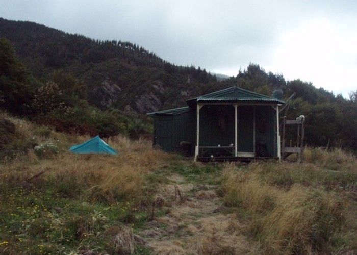
Cullen Creek Hut
This private 4-bunk hut is the only hut in the eastern Richmond Ranges. Sadly it is locked.
Camping spots exist nearby. The dunny is excellent: an A-frame 'school bus shelter', with no door & a view of the whole valley!
The hut lies near the head of Cullen Creek, on the Waikakaho Cullen Creek Track, and is marked on the P27 topomap as 'hut'. The track runs from the Queen Charlotte Drive between Picton and Havelock to Waikakaho Road off the north bank of the Wairau.
Following the Richmond Ranges main ridge west from Picton after 8 weeks without rain, I was forced to drop off the ridge seeking water; despite numerous streams shown, this was the first and only water supply found, some 500m below the ridgeline! As a further warning, the 'clear' face opposite the hut shown on P27 topomap is in fact 3-4m high manuka / fern scrub mix, and very tough going.
|
Owner
|
Owner: Private |
|---|---|
|
Category
|
Private hut |
|
Sleeps
|
Sleeps 4
4
|
|
Facilities
|
Toilet, Open fireplace |
|
Water supply
|
Natural water source
A reliable water supply is available 100m up the track from the hut.
|
|
Getting there
|
Cullensville Road roadend (P27 816877): Cut track (3km) Waikakaho Road roadend (P27 827806): Cut track (7km) Picton / Mt Freeth road (P27 940910): Ridgeline route - reasonable going through beech forest and occasional clearings after 1.5km of marked route through scrub beyond Mt Freeth TV tower (17km, 9 hours). |
|---|---|
|
Locked
|
This hut is locked. Enquire about access in advance. |
|
Bookings
|
Bookings required
Required
Contact Jimmy Stuart 03-574-2331 for more details. |
|
Altitude
|
300m |
|---|---|
|
Mobile phone coverage
|
No coverage |
|
Maps
|
NZTopo50-BQ28
|