Access
To do this particular tramp, two vehicles are required. We (my wife and I) joined another couple and a friend to form a party of five, which worked out well. The tramp starts at the parking area at the end of Clements Mill road, and ends at the gates of Poronui station. Four-wheel drive, or vehicles with reasonable ground clearance are recommended.
To get there, take SH 5 from Taupo to Napier for about 27km, and then turn right into Taharua road. Follow this right to the end, at the Poronui Station gate. The parking area is to the right of the gate, next to the heliport. Leave one car here, and then head back up Taharua road for about 6 km, and then turn left into Clements Mill road. Follow this right to the parking area at the end, where there is a dunny, and the Hinemaiaia track starts off on the right of the parking area next to a signpost and map.
Day 1
We met up with our friends at DeBretts in Taupo at 8.30 am, and were on SH5 a short while later. The weather didn't look too good, and near the turnoff to Taharua road there was a fair drizzle coming down. Fortunately the drizzle cleared up shortly thereafter, and we had no further rain until after reaching Cascade hut. We left the one car at the parking area next to the heliport at Poronui Station gate, and set out to the end of Clements Mill road in my wife's Honda CRV. This starts out as a broad, sealed road, but soon becomes a very narrow, winding dirt road, with barely enough room for vehicles to pass one another. It can be slippery when wet - take care. As it is 18km from the turnoff on Taharua road, it took almost half an hour to get to the road end. We eventually got onto the track just before 10am, and within 5 minutes crossed a swing bridge, after which the track veered left into the beech forest of the Kaimanawa Forest Park. A short while later we crossed over the Hinemaiaia Stream, and the track then carried on, up the true left bank. This part of the track is a very easy, comfortable stroll, which gives one the opportunity to drink in the lovely forest atmosphere. Everywhere there is a profusion of mosses and lichens of many different kinds and shades of green. The understorey is quite airy and open, and it almost felt like being in a fairy-tale enchanted forest.
About 50 minutes after the start, one arrives at the confluence of two tributary streams of the Hinemaiaia River, and the track now crosses over one of them. This is a good spot for a breather and a drink, as from here the track commences a serious 460-metre climb up the spur between said tributary streams, up to the highest point of this day's tramp, at 1240 metres. Keep an eye out for track markers, as at some points fallen trees obscure the track. We got lost for about an hour partway up the spur, but were eventually able to regain the place where we'd lost our way, and the track proper. The track marker had been attached to a fallen tree, and was pointing in the wrong direction.
From here the track sidles up the right side of the spur, up onto the ridge, and on both sides we were able to catch glimpses of the adjoining ridges through the trees as we puffed relentlessly upward. Eventually one notices another ridge angling in from the left, and you know you're getting near to the high point when this ridge converges with the one you're walking on. Look out for fungi on this track - there are many varieties to be seen. We saw some impressive specimens of bracket fungi (which grow on tree trunks), as well as other types of brightly coloured gill and wax-gill fungi. The most interesting one was the bright purple pouch fungus, Thaxterogaster porphyreum, of which we saw many during the rest of the day. After point 1240m, the track drops back down to 1080 metres, and then up again to another high point of 1159 metres. From here it's downhill all the way, steady at first, and then quite steeply for the last half hour before reaching the river. One can hear the Tauranga-Taupo River for some time before seeing it, and it certainly put new life into our now-weary legs. Just before reaching the river, one has to cross a small side-stream - there is a log across the stream for those with good balance. The rest - plunge in! Just after crossing the stream one reaches the true right bank of the Tauranga-Taupo River - swing left here, and follow the track markers upstream.
About 15 minutes later we spotted Stanfield's Whare on the opposite bank. This hut was built earlier last century by the grandfather of a retired director of the company I work for. He had told me that as a young boy he and his father used to stay at the Whare during their hunting trips into the Kaimanawas. It is now disused, but still looks to be in reasonable condition. Unfortunately we didn't have the time for a closer inspection - next time maybe. Shortly after this we spotted a sign some kind soul had carved on a plank, indicating that we had 15 minutes to go to Cascade hut. Unfortunately our sigh of relief was soon tempered by the fact that we had to cross the Cascade Stream - not possible without getting the feet wet! The hut was reached 5 minutes later, with many exclamations of gratitude. Total time taken - about 8 hours, (including stops, and getting lost/finding the track again) - the literature states 6-7 hours, which is about right, provided you don't get lost! Total distance covered on day 1 is 10km.
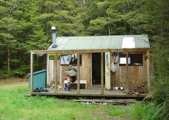
The Cascade hut (category 3) is set in a small clearing about 50 metres from the river, and is a tidy, six-bunk (foam mattresses) affair, with a wood stove in the one corner, and a table with three very comfy office chairs in the other corner. It has a small covered veranda, with a small bench and a clothes rack on which to dry wet socks, etc. There is fairly new fibreglass dunny not too far away. The hut has it's own outside water supply, with a sink. Bird life is abundant around the hut, and we saw tomtits, fantails and some very inquisitive NZ robins.
We ended the day with a hearty dinner, several mugs of coffee/tea, reminiscing about previous tramps, and speculating about the long haul the next day.
Day 2
After a rather fitful night's sleep (due to an itinerant mouse, rustling in the food packets) and a good breakfast, we were up and ready to go by 8am. The track heads off from the side of the hut, past the dunny, over a log and into the bush, and then meanders along the true left bank of the Cascade Stream for about 200 metres, to a side stream (not shown on the map) coming in from the right. From here the track markers pointed us across the Cascade stream, which we were unable to cross without wet feet. On the other side there were track markers pointing both up and downstream. Thinking we had missed something, we headed back down the true right side for a while, but the markers came to a dead end. We retraced our steps to the crossing point, and then followed the markers upstream. At one point the track then clambers up the bank, and a short while later disappears over a 6-metre drop into the river. It was obvious that the bank had been washed away here recently, as there were quite a few trees lying in the river.
We then scrambled into the bush, staying as close to the river as was safe, and picked up the markers again about 50 metres afterwards. Not long after that, the markers indicated that the track went back over to the true left bank. We were somewhat confused at this stage, as the track was shown on the map to follow the true left bank all the time. We decided to persevere, however, and half an hour later arrived at the signposted junction with North Arm track (to Boyd Lodge), to our great relief. Do not turn right here - stay on the track to the Kaipo saddle/river.
Shortly after the junction, the track starts a 200m climb up the right side of a spur, onto a ridge to 985m, through open, airy beech forest. After reaching this high point, one walks along the gently undulating ridge for about 30 minutes, after which there is a fairly steep descent to the Kaipo Saddle, and the headwaters of the Kaipo River. The map shows the track as following the true right bank of the river literally all the way down to the junction with the Te Iringa-Oamaru track - do not be deceived! The map is dead wrong! Only on the odd occasion does the track follow the river bank - the rest of the time it is a great, wet, river-bash, all the way down. Generally it wasn't too difficult, but on many occasions we had to stop and search for ways around huge piles of jumbled logs, slips, fallen trees and the odd set of rapids. Track markers were occasionally seen on trees, generally pointing downstream, and occasionally into the bush for a short cut around a small gorge or dangerous part of the river. On one or two occasions we saw markers pointing into the bush, but after searching fruitlessly for a track out of the river, realised that the marker had been fixed to a tree that had fallen over (and was originally pointing downstream).
After about two to three hours the river widens out somewhat, and the going becomes a lot easier. We were walking mainly on the pebbly riverbed, crossing over from corner to corner. As the weather had been very kind to us, this was tramping at it's very best, with a gentle breeze wafting around us, and the occasional patch of sunshine through the trees. The river flow appeared to be at normal levels, but looking at some reasonably fresh tree fall, some sizeable slips, and some impressive piles of jumbled-up trees and logs, it was very evident that in the not to distant past this river had been in serious flood. Pumice is very common along the river - one of the few rocks that are light enough to float - and it was sobering to see bits of pumice stuck in tree branches at head level or higher! We had a bit of fun throwing some into the water, then watching it float away.
We boiled the billy and had a very pleasant lunch on a pebbly island at about 1.30pm, and eventually arrived at the junction with the Te Iringa Oamaru track about 10 hours (including stops) after departing from the Cascade hut. Distance walked up to this point is 11.7km, according to the map. Take note that about 45 minutes before the junction, the track leaves the river, and heads off at a gentle incline up the true right bank. Also take note that you should keep track of where you are in the river at all times - check the map regularly, and tick off the tributaries as you pass them - a good way of knowing when to start looking for the exit from the river. Without question, this was one of the nicest tramps I've done so far in New Zealand, but take note that it's not a walk in the park (pardon the pun!) - track finding skills are essential, and this should more accurately be classified as a marked route, rather than a track. There were many high points on this day's walk, including seeing a brown trout at close quarters, and a metre-long black eel making its way upstream. Deer sign was also evident on some sandy parts of the bank, and from some makeshift campsites it was also obvious that hunters frequent this river during the season.
We had a quick stop and a drink at the swing bridge, and then set off down the Te Iringa-Oamaru track, to the Oamaru hut. The track was of a high standard, wide and easy, and we were able to maintain a good pace, arriving at the hut exactly two hours (and 7km) later. About 15 minutes before the hut the bush gives way to wide, open grassland dotted with occasional patches of Manuka scrub.
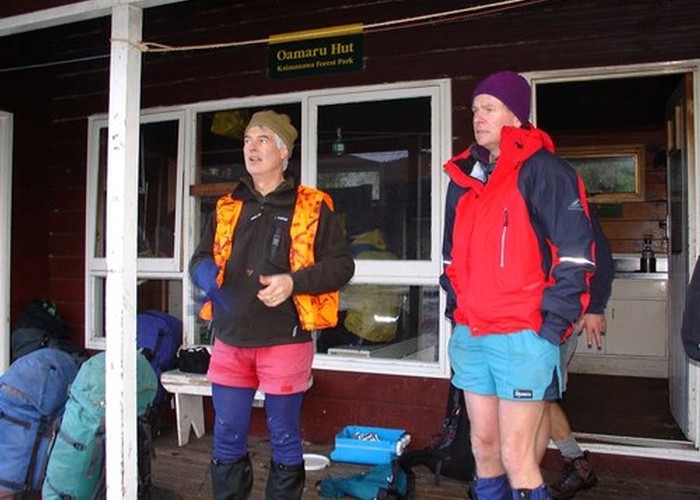
Oamaru hut is situated on a small level site on the side of a low ridge, about 15 metres above the valley floor. From the hut's veranda there are expansive views over the grasslands, the Oamaru River, and the bluffs and ridges surrounding the valley. It is a category 2 hut with 12 bunks (foam mattresses on sprung bunk beds!) in two rooms, one on each side of the veranda. The kitchen is centrally situated, and has a fireplace with wood stove, sink (with water supply), and table with benches. We noted that the rooms were equipped with gun racks - the hut is popular with both hunters (in season) and fishermen.
We were very tired, and extremely hungry, and after a hot drink and a satisfying meal on the veranda, we retired to bed.
Day 3
We awoke to a grey, overcast sky, with a light drizzle starting to fall. Whilst enjoying our morning coffee and breakfast on the veranda, we noticed a helicopter flying past, heading south. Just as we were about to set off from the hut, the same helicopter landed on a level site just below the hut (impressive!), depositing a load of fishermen wanting to try their luck in the Oamaru River. After watching the chopper depart, we set off to the valley floor down the short set of steps to the right of the hut. Wishing the fishermen luck, we followed the track through the grass.
About 10 minutes later we arrived at the Oamaru river (two crossings), which was not difficult to cross. On the other side look out for markers set on poles - from here the track is on private property all the way to the end. Soon the track heads uphill, through a gate (Poronui Station boundary), into plantation forest, and follows a farm road virtually all the way. Keep an eye out for the orange markers on poles.
Not long after entering the plantation it started raining - and did not stop until we arrived at the Station gate. We arrived there wet and tired, but with a huge sense of appreciation for the incredible beauty and variety of experiences available to trampers in New Zealand.
Day 3 would be considered very easy, but perhaps a bit of a letdown, in the sense that one follows farm roads through plantations. It is not unpleasant, however, and it allowed us to observe some aspects of what goes on, on a station such as this. It took us just short of 4 hours, and we estimate that the distance from the hut to the end was between 12 and 14 km.
Conclusion
This tramp was a great experience, all in all. We were, however, acutely aware of its remoteness, and should something happen, it will take a long time to get help. Be prepared for emergencies and check the weather forecast beforehand. Also be prepared for tramping in wet boots/ wet feet for most of the three days. This is not a tramp for beginners, unless you go with someone experienced, and you will need to be fit. The second day, especially, is very long (18.7km). We were also fortunate to have both huts to ourselves, and did not meet any other trampers at all. This might not be the case for everyone, so take a tent. Map - Terramap: Kaweka & Kaimanawa Recreation Areas 1:50,000 topographic map.
So, if you want seclusion, peace and beauty, do this tramp - you'll be glad you did!
Further reading:
- DOC pamphlet, Kaimanawa Forest Park, Recreation Information
- Lonely Planet walking guide, Tramping in New Zealand
- Nature Guide to the New Zealand Forest: John Dawson & Rob Lucas (Random House publishers)
- Mushrooms and Other Fungi of New Zealand: Don Horne (Reed Books)
- The Field Guide to the Birds of New Zealand: Barrie Heather & Hugh Robertson (Penguin Books)