
Frank was keen to check out the ever-diminishing lake which had formed after the Kaikoura earthquake upstream from Stace Saddle in the Hapuku R, unfortunately drowning the two small huts there. One of them had been a totara slab hut that Frank and I had stayed in, prior to climbing Manakau back in the day. We'd gone back there in May, 2018 on a chilly but sunny day trip. En route to the lake we'd been intrigued to see a very large dead but intact stag in the river bed. We'd left the Hapuku track and dropped down to the river bed at the junction of the two branches of the Hapuku. I noted since then an actual track had formed exactly on the route we'd taken and was now marked on the topomap.
Frank suggested we do the loop in reverse order this time as above. I said with our being retired, we could take 5 days to do it instead of the 4 we took last time. Alas, he derided this and said we could do it in 3 days! This meant checking out the lake on the same day after a good effort of travelling from Kowhai Hut to Hapuku Hut over the rough western side of the saddle. We'd actually failed to notice a section of track when descending that side and travelled down large boulders in the increasingly nasty river itself on our previous crossing. And I hadn't forgotten the long tedious walk out, stopping at Kowhai Hut to wistfully wish that that was the day's destination but work had beckoned. His plan for the third day was for us to climb 1200m to the summit of Mt Fyffe and then descend 900m to the Mt Fyffe carpark to complete the loop. It's not that I couldn't do that or even suffer from doing it at the time, but what it would do to my old body, having done it? However Frank was obviously from the school of thought that what doesn't kill you, only makes you stronger.
We finished packing on the Tuesday morning and set off, having a late lunch at Cheviot's Number 8 cafe with its newly sealed asphalt car park. Then we followed Ludstone Rd, deviating to go up Mt Fyffe road but I soon noticed this wasn't going to take us to our road end but actually to a little loop walk in a different location so we turned around and went west up Postmans Rd which eventually got us to the Mt Fyffe car park. Frank and I went and had a look at the DoC sign which outlined the travel times in the area. Frank then wanted to figure out whether to go there via the Kowhai Hut which gave a travelling time of 3 to 4 hours, or Mt Fyffe Hut which would take 3 hrs DoC time. As far as I was concerned, we'd already decided what we were doing so I flounced off, leaving him to it as we had around 3 hours daylight to locate Kowhai Hut in from a devastated riverbed.
The Kowhai was up a bit and murky, following rain during the weekend. I heard a stag roaring and felt a bit nervous traveling on my own. The map showed a track starting just after the track junction from the Spaniard Spur track but there were also cairned shortcuts if you kept a lookout at logical places. I was able to travel quite a way on the true left but eventually needed to cross to the other side. Fortunately the river bed was quite flat and braids were easily crossed. At one place a crossing looked like an efficient shortening of the distance but the current and volume advised me to continue traveling on the true right. I would need to cross to the true left again to gain the track that takes one to just a little downstream of the hut and looking at the map showed a fairly level wide open area downstream of the Spaniard Spur Hut. In actual fact I crossed even further downstream, choosing a good wide crossing point and taking it very carefully as there was still a bit of current in the river, making the walking stick vibrate, and the river level was above my knees.
I left little indicators for Frank to show I'd managed the crossings: a strip of orange polar fleece tied to a shrub at the entrance of a bypass track and a plastic bag (sorry), tucked into a cairn at another start of a short track. I found a great former flood route that gave me fast travel to where I needed to climb up onto a terrace where a delightful recently recut track through kanuka took me a good distance before briefly dropping down to the river bed due to a flood wiping out the track. The track climbed back up into the forest then finally came down to the river bed. Two large orange triangles a little further upstream on a terrace on the true right indicated the start of the track to the hut as I anticipated. Thankfully the river was now clear and easy to cross as it was Snowflake and Middlehead Streams that brought the cloudiness and a good deal of volume into the Kowhai R.
I crossed to below the terrace and found a place just down from the orange triangles (which were affixed to an ancient sign announcing the hut close at hand) where I could climb up the almost vertical edge of the terrace - caused by a recent wipe-out flood. Here I got out 2 reflective markers and stuck them to the triangles as Frank would be coming in the gloom half an hour after I had and stuck another one on a small triangle higher up still where the track leveled to take me to the hut. I noticed branches of manuka had been cut so I grabbed one to drag to the hut for firewood as you never know what you'll find at a hut.
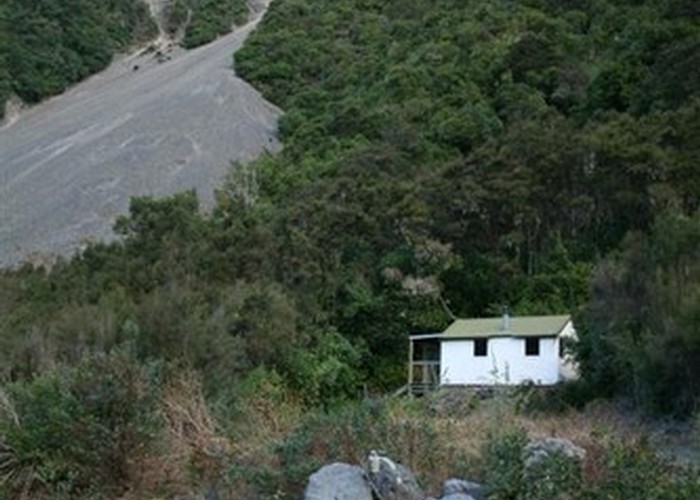
I arrived at 6.30pm to a surprisingly empty hut as I'd been following fresh footprints up the river bed. It had taken me less than the DoC time: 2 hours and 40 minutes. I immediately began preparing materials for a fire to broadcast to Frank that the hut was now occupied. However the manuka was very bendy and laboursome to render smaller for burning. I set off to see if he had reached the river bed. On the way I 'lost' the track and had to retrace my steps, backing out of a clearing that was going nowhere. I went to where the reflective markers were placed and there was no sign of Frank, only a sea of blackness indicating the river bed. So I went back to the hut, harvesting long-dead and easily broken up matagouri on the way and placing it on another cut branch of manuka as a make-shift carry cradle. Then I returned to the lookout, having once again leaving the track very briefly at the same point and still no Frank. It was after 7pm by this time. I grabbed more nice dead dry kindling and phew! there he was at the hut.
He'd failed to see a way onto the terrace or the reflectorized orange triangles and traveled up the river bed looking for an ancient track that comes down from the hut to the river for water collection. With the lovely water tank at the hut, this track was no longer used so was completely overgrown and the edge of the terrace was now cloaked in tall kanuka forest. So he traveled further upstream of the hut, having no confidence that the hut was correctly located on his GPS. Finding no sign of a track he'd then traveled downstream searching on a microscopic level and soon detected the flattening of a former foot pad where the track had climbed up between terraces. Behind a tree was the start of this no-longer used trail so up he went and popped out right by the hut in the large long clearing. He'd been thinking all sorts of scenarios such as what if I'd discovered there was no longer a hut here and had gone up Spaniard Spur and I'd had similar thoughts: what if he'd decided he didn't like his chances crossing the river as he can't swim and had decided to go to Mt Fyffe Hut for the night...
However at least I was spared the misery of trying to find the hut in the dark with all the clues wiped out by flooding. I got the fire going with that lovely matagouri and cooked a quick meal. As soon as I lit the fire a friendly and communicative Czech couple arrived from a day's journey over Mt Fyffe and down from Kowhai Saddle with a good deal of it in the dark, losing the track despite DoC having cut and marked it 3 months before. What a mission! Frank set to cutting wood with his silky saw and piled it in the woodburner so I was soon sweating like a pig. Lukas also cut smaller stuff (with a very blunt saw) which I said would be good for the next party coming in. We went to bed with our bags nestled near us, handy for when the hut finally cooled down.
The following morning I rose after 7am, mindful of not making too much racket for the Czechs as they only had to walk out to the road end. They soon got up after Frank and I had exchanged good mornings. We were ready to go by 9am and we would have a long day with a DoC estimate of 3 hours to Kowhai Saddle and 3 hours to Hapuku Hut, plus 5km to the lake which would mean at least 4 hours for a return trip to and from there. We set off on the recently cut and marked track and immediately I noticed our having to brush our way past saplings protruding from the side of the track. DoC had spent a day travelling down with most of it dedicated to the very much needed marking rather than snipping small stuff. The small rough track dropped down to cross the larger catchment of the Kowhai and then we traveled up a smaller tributary which leads to the saddle.
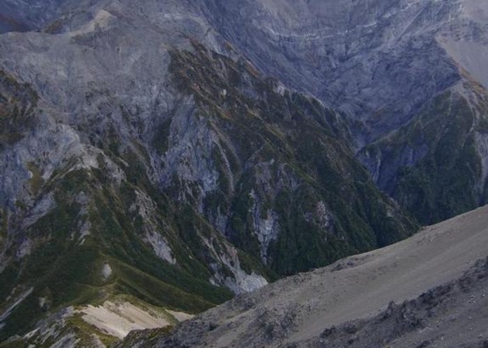
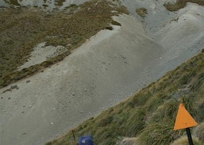
The earthquake and subsequent floods had done their work. Sometimes we had to travel in the stream and crossed it several times in steep cataracts. There were orange markers painted on prominent boulders. I spotted one and obeyed its indication to cross the river to the true left but while sitting on a boulder as the rocks were too slimy to stand on to step onto the next slimy boulder, I noticed a fricken orange triangle also painted on a rock on the true right, I guess they didn't have grey paint with them...It took us the full 3 hours to get to the saddle with sometimes having to cast about to figure out where to go. We stopped in a magic wee spot for an early lunch at 11.40am in the sun and lee of the breeze on a shingle terrace where some clever clogs had constructed a flat footprint for their tent by building a rock wall below to contain the shingle and maintain the level site. This made for an ideal seating for lunch with rocks to spread the lunch ingredients out on. A little stream ran close at hand to make it the ideal campsite (though not in a southerly).
We took the full hour to recover from the experience of traveling to the saddle. Another 15 minutes and we were at the saddle itself after pushing through verdant herbage and low scrub. The sign said 2 hours to Hapuku Hut. With just over 3kms to go, that sounded generous. I noticed a nice looking biggish campsite on the Hapuku side set in a low level spot though not completely sheltered from a southerly and completely exposed to the north and east, with no water of course. We sidled to the right through big tussock on a track which then took us down soft scree to a little streamlet seeping from the scree and rocks above. I stopped for a drink then we crossed to a track marker indicating the best travel on a foot pad through low grass. The river bed offered surprisingly consolidated travel as well. We briefly left the river to take a short track on the true right via grassy low scrub and carefully in my case rock-hopped across a side stream on the true left after travel along through forest, including over a large windfall that was there 5 years ago.
The track was delightful, especially after the head of the Kowhai. Wide and flat sections were savoured. We remembered what I call Cannonball Stream because there are round and very heavy small rocks to be found there. What would be their geological origin? Frank had souvenired one last time and there'd been one at Hapuku Hut too. This stream is the standard route to climb Urewau according to the hut book. It wasn't long before we dropped down and popped out of the forest opposite the hut. A line of large boulders across the river meant the boots could stay dry. We walked up towards the hut with my noting felled kanuka dried out in the sun. No one at this hut either. Frank had forgotten how lovely it was. Perhaps that's why he was happy to stay put and not spend the last hours of daylight traveling to and from the newly formed lake. With the big day ahead tomorrow I wasn't keen either and we soon worked out after an exhaustive read of the hut book that a second trip, this time starting in the Hapuku road end would be worthwhile particularly with several mentions in the hut book of "hot springs up the river" - which seemed to be upriver of the lake, not the hut.
It had only taken us one and a half hours to get to the hut. I gathered the makings for a fire but it was a warm evening despite our only having an hour of sunshine after arrival. Although I'd soaked my home-made dehydrated chickpea meal for a few hours, they were still a bit solid and needed chewing but it was very tasty all the same. I was in charge of stoking the fire this evening and was also too heavy-handed with the hut getting very warm once again. No one turned up though. We left after 9am the next morning and once again enjoyed the attractive walk up valley to the saddle. I spotted a cannonball and put it on a cairn. There was the odd small snail shell around as well. We retraced our route to the saddle and Frank filled his water bottle but I waited until that final streamlet to fill mine. We stopped for lunch at the saddle. The DoC time to there 3 hours but it took us just over 2 hours. I picked a spot to the lee of the southerly amid snowberries and visited the campsite which was festooned with even more snowberries.
Frank led the way up the well-poled route towards Gable End. It was a bit scrambly with the scree climb being a bit tiring so we worked hard for our 440m climb to the summit. Frank had said there was another 100 climb to Gable but I pointed out it was actually only 60m as we skirted the top of Gable. It was now misty. This time we could avoid the scree but it would have been lovely for people descending. Frank was annoyed that I persisted in traveling on the windward side. But the lee was not an option as it was rough with steep drop-offs. I offered to stop so he could put on a jacket if required and shortly afterwards did this myself but had to take it off when faced with the final height gain to Mt Fyffe. By this time we were on the ancient, no longer used 4WD track. It was disappointing to see what could be pinus contorta spreading all over the show. It was planted there for erosion control back in the day. Towards the summit, the mist cleared to blue skies with cloud blanketing on both sides, the sea side being more stratus than the Kowhai side so no views today.
We dropped down and met a pleasant couple with 2 dogs. He was carrying a rifle and we said we'd heard plenty of deer roaring on the trip. One dog was a placid, friendly huntaway and the other was a short-coated collie bitch. They were staying in a tent by the hut and said quite a bit of rain was forecast so probably wouldn't be able to travel down the Kowhai via Spaniard Spur. Then there were a couple of young women going up slowly after a rest stop. We descended to the hut for a cup of tea and vermicelli for me. It was good to have a lengthy break. The rural couple arrived and by this time there was light drizzle. They hoped they'd be able to move into the hut for the night if no one objected to the dogs being inside. I said there was a good chance that no one would object. We couldn't see any sign of the girls planning to stay though they only had day packs and hadn't returned from the summit.
We donned our wet weather gear and headed off for the 900m descent to the car park. The descent is the same from Blind Saddle to the road end there but this road had much finer stones and more vegetation so wasn't as grinding. We got down in 1hr and 22 minutes with stops to remove rain gear but it began raining properly just before we got there. I changed in the toilet as per usual but Frank went to erect a tarp and poles to change under. I returned to his snarling because integral tie downs were missing from the boot of the car so he'd had an unpleasant time improvising in the rain with our walking poles. We had our sandwiches and drinks and set off in quite heavy rain which persisted most of the way to Christchurch. It was the Thursday before Easter so quite a bit of traffic coming from the other way, dazzling Frank with their headlights. So he drove slowly and carefully.