
It would be too dull to just go to the lake and back via the East-West Route from Molesworth Cob Cottage so I suggested returning over Carters Saddle and Barefell Pass. Frank further refined the circuit by cutting off 4km of travelin by traversing an unnamed 1500m saddle just east of the pass into the head of the Awatere. It’s always more intriguing going via the road less traveled. We had no idea whether the valleys would be choked with matagouri, briar rose and other nasty weeds but found out that each valley had its own character and once we got over Robinson Saddle on the first day, it became very attractive.
We started off by driving to the campsite nearby and staying the night and then parked the car in the official place for people doing the East-West Route, right by the ranger’s cottage. Just as well as I left the window down and the kind ranger rigged up a rubbish bag to cover it from dust and thieves. We then set off walking in the heat along the 4WD track where the only marker we ever encountered indicated the start of the route. We crossed the Awatere, continued along the 4WD track and then came to a junction where I queried if this was where we should follow a smaller track leading down towards the river. Frank was confident this was not the case and I was too lazy to check on my phone mapping software but we should have. No matter, our road carried on in the general direction and then ended suddenly as indicated on the map.
We got to see a friendly horse who I hoped wasn’t keen on our company because it was thirsty in the heat and then a paddock of young steers who didn’t seem to have anything in the way of pasture grass or water either. We made our way down through willows to cross the Awatere again and found the 4WD track on the true left that we were meant to be on. Eventually we then had to figure out where to leave the track and travel up Robinson Ck. Frank had his map well-buried in his map and exhumed it while I went ground-truthing. The 900m contours were virtually meeting on either side of the creek but this turned out to be a nothing on the ground. The creek itself was very easy to travel up, the whole way.
We soon met a group of beautiful horses and figured out there were no cattle in the creek so the water would be safe to drink so we stopped for lunch. We traveled on, avoiding thickets of briar rose by using animal trails and eventually reached the start of the climb to Robinson Saddle. The map showed a pack track but there was only long grass and a myriad of streams and seepages. Frank asked me if I would stop to get water but I could see that water would be available a long way further up the creek yet, almost at the saddle. After a further 1km of travel, I collected water from a small stream where we startled a family of Canada geese. The parents set off in 2 directions, climbing the hill, one going our way. By now it was mercifully overcast for the ascent.
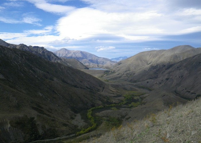
We negotiated the long grass and then I traveled where the hypothetical pack track was marked and Frank stuck to easier terrain. There was a pleasant breeze at the saddle and a good view of Lake McRae in the distance and the silty Tweed River we would be traveling up the next day. We carried on via a small animal trail in the scree to another saddle and then sidled the face of a hill to avoid having to travel along the ridge. The animal trail was virtually non-existent here. Regaining the ridge on the eastern side of this little hill, we descended quickly in pleasant scree and soft dirt, startling goats who were responsible for multiple trails we could choose from. The map showed the pack track descending a spur into the valley but we were leery of the abundant briar rose so left the spur earlier to pick a scrub-free route down into the valley, on the north side of Pt 914. While we were higher up, we had a good view of the willows and briar rose choking both sides of the stream we needed to cross to get to Lake McRae Hut.
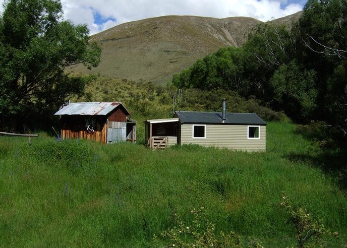
The valley was swathed in long luscious grass. We could see a cow and calf in a clearing in a paradisiacal setting. We had a look at the stream crossing but after a drink I said we’d be better off going a bit further downstream as the willows and briar rose looked narrower there so off we went and it proved to be so. Not long after this we met up with a good strong animal trail that took us all the way to the hut, passing flowering gentians. I was a bit disappointed with the old shack and thought it wouldn’t be sandfly-proof but we soon realized there was a lovely recently renovated hut right beside it. We pushed through long foliage to the obviously unoccupied hut.
Our first task was to get some water so I set off with a big cauldron. A note in the hut book said if there was no water by the hut, to travel down valley past the toilet, dog kennels, and horse paddock for a few minutes to where it emerged from a spring. Sweeping left and right, I eventually found the spring and harvested mint as well. With its being overcast, I figured it would be better to visit the lake in the morning and that it should only take half an hour to reach it from the hut. I could see a 4WD track bulldozed across the face of the low rise that led to the lake.
The hut pantry was well-stocked by musterers from Molesworth so I took some Arborio rice and maple syrup to make a rice pudding, augmenting our rations. We had a pleasant evening and I started reading “for the love of horses” by John Gibson, recounting his fascinating memoirs of working on various stations, breaking in horses during WWII and beyond. He had an idiosyncratic style of long sentences but they were very descriptive of the life, horses and characters with plenty of his philosophy sprinkled throughout. He worked unbelievably hard in some of his jobs. During the depression, it was sometimes for board only.
In the morning we went up to the lake, pushing through a narrow band of scrub before the shoreline willows. We started a flock of geese who took to the lake but we couldn’t see the Australasian grebes that are resident. It looked easy to travel along the northern shore if people wished to visit Elliot Bivvy and beyond when the lake level was this low. Perhaps we could have made this our objective but another time, perhaps? We packed and headed off to Carters Saddle and were pleased to see it was along a decent animal trail leading us through the briar rose. It was a hot day so we stopped for lunch on a little escarpment to catch some breeze from time to time as there was no suitable shady spot amid the prickly scrub. We continued towards the saddle, meeting a piglet but no mother around, thank goodness.
Soon in the distance we could see where the trail left the stream at a junction where the tributary was now clear and potable. We climbed and then I lost the right trail and had to climb up the slope to rejoin it. By now it was an old bull-dozed track and very easy going. At a willow we halted for yet another drink and were pleased to see fantails flitting in the tree and then we startled 2 small flocks of chukar! What a thrill as it’s only the second time we’ve seen them ever. There was a gate at the saddle so we carried on through it down via the bull-dozed track which varied in quality. Sometimes, it got swampy and it was easier to leave it and sidle above. Animals had thought so too. Frank checked in to ensure I knew where to leave the valley and cross a jumble of low spurs to get to our next valley just down from Pt 1135. I suggested we sidle early, gaining height though our animal trail was very subtle at times. We dropped into yet another tributary of Dillon River and this valley had no stream flowing but was full of lush grass though which we followed a good trail with inevitable pig encounters.
Then we had a final crossing of a low saddle into the last valley to look for a campsite. I said we’d better make sure there was a stream in this valley and fortunately there was on the true right. Frank said tomorrow would be an easy day but he meant easy navigation and I thought he meant a short day so suggested we halt and camp not far up the valley, on shingle deposited by some fresh. We would have been better carrying on for another hour in hindsight but this was a lovely sheltered spot right by the water’s edge, just north-east of Pt 1175.
I flattened out the shingle and yanked out deep-rooted vipers bugloss for our tent site. We had a lovely evening camping out in mild weather with a breeze that settled down as dusk came. In the morning we continued up the valley via strong trails on either side of the stream to the saddle via leads of tussocks. We stopped at the final trickle of water for a drink and to fill our bottles. Near the top of the saddle, I was delighted to see penwipers but Frank was concentrating on his foot placements in the scree and passed them by. I sidled to the lowest point of the saddle and discovering cowpats, picked one up and suggested we play Frisbee with them. I’d been wondering how far up the valley the cows had gone but these were from the Awatere side.
We stopped for lunch out of the breeze in a sunny spot. There was an intriguing green bush growing nearby which turned out to be some sort of whipcord. We could see a group of 7 cows towards the bottom of the steep descent and snuck around them without disturbing them. The final section down was via bony ribs of argillite with fine scree gullies. Frank wisely moved to his left to avoid them but I took on the challenge and should have put my gloves on as I slipped and lost some skin on my palms.
We reached a small side stream and decided this would be the least contaminated source of water for a few hours so filled up the bottles completely. As we took the strong deer trails down valley we mustered every bovine along despite our futile tactics to sneak past them until we came to a large fence across the valley. The Awatere was churned up and muddy. The mustered heifers cleared us a space to open the gate for them despite abundant long green grass all the way up the valley. Sorry girls. We came to a clear side stream but didn’t trust the water to drink but it was heavenly poured over my head. Frank was very hot by now. Then we came onto the 4WD track and followed it down until it seemed to disappear and we pussyfooted through some welcome shade in the willows. I ventured there would be a 4WD road higher on a terrace as there were beehives there but we were happy to stay on our course. I could see a gate in the distance and sure enough, we joined again and it was a tedious walk down valley with our going slower and slower with the heat. I developed a pain where the ankle goes into the shin like a shin splint I imagine and slowed down, walking with my foot turned out to avoid painful spasms. We were hoping to get to the campground to early enough to be allowed to drive through to the Acheron end. We didn’t have a spare dinner to camp at the Molesworth end.
We reached the car at 6.20pm and the very kind ranger allowed us through to drive back to Hanmer. It took us 1hr and 20 minutes, roughly the same time it took for us to drive up valley a few days before. My foot problem seemed to be a slight bone misalignment that corrected itself. Once through we stopped to change our clothes and have a snack under some power lines that were buzzing so I got Frank to shift the car a bit. An attractive place to camp sometime. However we got quietly bitten by mosquitoes we think. We drove to Hanmer and went back to that nice fish and chip shop but the Japanese waitress said they were out of GF hoki so we had to settle for a burger each. My eyes were too big for my stomach so Frank ate half the chips we’d bought and then gave up.
The circuit was a success: a hut bag then off the beaten track which made for pleasant navigating via surprisingly amiable vegetation with the bonus of meeting some very lovely people.