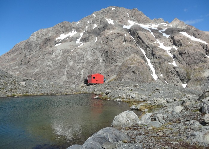
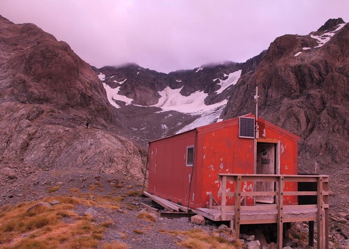
Barker Hut
Arthur's Pass National Park
- 2 – 3 days return by the same track
- Medium
- North bank road end to Anti Crow Hut, 1 hour
- Anti Crow Hut to big bend, 1 hour
- big bend to Carrington Hut, 1 hour
- Carrington Hut to Clough Cableway, 15 minutes
- Clough Cableway to Cahill Creek 1 hour 45 minutes
- Cahill Creek to Barker Hut 1 hour
Surrounded by glaciers at the head of the White River, this is the highest hut in Arthur's Pass National Park.
|
Walking time
|
2 – 3 days
11 hr – 15 hr
|
|---|---|
|
Distance
|
48.0km |
|
Type
|
Return by the same track
|
|
Grade
|
Medium
Unsafe during winter and early spring due to avalanche hazard. Significant river crossings, and some alpine route finding. Grades explained
|
|
Bookings
|
No bookings — open access
No — open access
|
|
Starts
|
Klondyke Corner, SH73 12km south of Arthur's Pass Village |
|---|---|
|
Maps
|
NZTopo50-BV20
|
|
Altitude
|
640m
–
1,560m
Altitude change 920m
|
This route is almost entirely along riverbeds and is only realistic with low river levels. The route crosses a stream off the White Glacier just before the hut that can become impassible in rain. Numerous avalanche paths cross the route up the White River, making it unsafe in Winter or early Spring.
Two routes lead up the Waimakariri River to Carrington Hut. If you are walking over the weekend, it makes sense to cover the tedious plod to Carrington Hut on Friday evening, so you have more time to explore around Barker Hut the next day.
Waimakariri bridge to Carrington Hut
O'Malley's Track is a high water trail leading up the south bank from the southern end of the Waimakariri bridge. It keeps to the bush edge and takes about 5 hours to reach Carrington Hut. Side creeks such as Anti Crow and Greenlaw may be impassible anyway.
The low water route sets off from a road end on the north bank -- turn onto a gravel road at Klondyke Corner and drive up to the car park. Set off directly up river over boulders and river flats, crossing as needed. Pass Anti Crow Hut, and some roches moutonées at the "Big Bend" as the river turns about Mount Stewart. There will be another river crossing to the true right around here. From here, the route leads over stable herb-covered river flats that offer much quicker walking.
Carrington Hut is across the river from Mount Carrington, and a cairned track leads into beech forest on the true right just before the White / Waimakariri confluence.
Carrington Hut - Barker Hut
From the hut, a bush track heads up the White River, breaking out onto riverbed in a few minutes and passing a slip where a small knob of rock has collapsed. The Clough Cableway is nearby, providing access to the true left bank or up to Harman Pass. Cross to the true left bank around here -- the cableway is hard work, and a river crossing is generally the way to go.
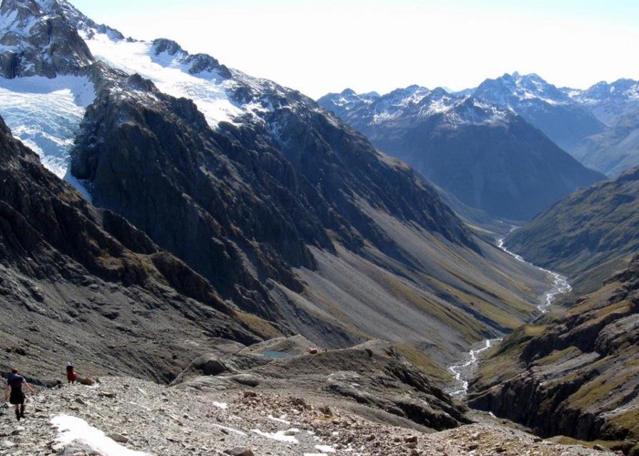
Beyond the cableway, the long valley of the White River opens up, with views of the White Glacier at the head, along with the prominent rocky knoll atop of which the hut sits.
The true right bank of the river is steep and bluffy beneath the rigorous slopes of Camp Spur and Mount Harper; the true left bank is buried in scree shed from the glaciated Shaler Range. The route leads up the riverbed and onto the tussocked slopes as necessary. Kilmarnock Falls is nearby, and a good 152m drop.
Up valley, a track leads onto the hillside to bypass a gorge and waterfall where a long slip has dammed the river. A few inconsistent snow poles mark out a route onto the hillside, but there is not much in the way of a defined track. Drop back to the valley floor beyond here and cross the creek below Cahill Glacier.
At the head of the valley, the climb onto a golden yellow spur and sidle across to the handsome ravine beneath the Marmaduke Dixon Glacier. Cross the creek as best you can (this was once bridged, but no longer) and drop down the ravine's true right bank until you can climb out safely. Note that a few old cairns here mark the way to the bridge which no longer exists.
From here, a cairned route climbs up past the rocky knoll to the hut, perched on top. If you don't find the cairned route, simply keep the knoll on your right and head on up.
The triangular lower chute of the Cahill Glacier is viewed straight out the hut window, while the large basin of the Marmaduke Dixon is off to the side. A straightforward walk leads over moraine and glacier-carved rock to the White Glacier and a snowfield beneath it, and onward to the ridge near White Col. Excellent views here of the glacier, Mounts Murchison and Harper, as well as the plunge down into the Burnet Stream.
Walking times
These times are an easy pace at low river levels.