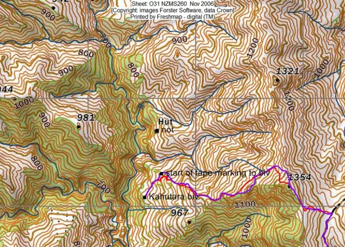
Kahutara Biv route
- 4 hr – 6 hr return by the same track
- Medium/hard
Mostly 4WD drive track along the DOC East-West route, with some off-track travel up over the ridge to the biv. Great views back towards Kaikoura, open tops and a quiet tucked away biv that gets very few visits. A worthwhile weekend trip in itself or an interesting side trip if doing a longer trip along the main track to/from the Clarence.
|
Walking time
|
2 days
4 hr – 6 hr
|
|---|---|
|
Distance
|
11.0km |
|
Type
|
Return by the same track
|
|
Grade
|
Medium/hard
Snow skills likely required in winter. Good navigation and route finding skills required once off the 4DW track. Grades explained
|
|
Bookings
|
No bookings — open access
No — open access
|
|
Starts
|
Start on the Inland Kaikoura road and park on the Northern side of the bridge that crosses the Kahutara River (Doc sign). |
|---|---|
|
Ends
|
Kahutara Biv |
|
Maps
|
-
|
|
Altitude
|
200m
–
1,354m
Altitude change 1,154m
|
Follow the 4WD track up the True Left of the Kahutara River until it joins the 4WD track as marked on the topo map where the river forks and the track starts to climb the spur. Follow the track up Driving Spur past Bushy Saddle and then Blind Saddle.
Shortly after Blind Saddle (approx. 700m) there is a higher unnamed saddle. Turn off the 4WD drive track here and head West up to the ridge.
There are some old DOC marker poles here and there which you might pick up in the odd place, but generally the route is not marked from the 4WD track.
Head North along the ridge for a short way to Pt 1354, then start to follow the ridge down toward the biv. Almost immediately as you start to head down there are some old DOC marker poles that bypass a slightly steeper short section of ridge on the Northern side. Regain the ridge and continue down towards the biv.
.Lower down on the spur there is a reasonable amount of scrub. To avoid the worst of it, at about the 1000m do not head directly for the biv, but instead keep to the prominent spur that leads slightly to the North of the biv.
Once you're on this spur, there are occasional bits of cruise tape to guide you through areas that have had a bit of snipping. On the section of the spur which is heavily scrubby, there is a wee animal trail on the northern side of the spur.
At 785m a.s.l. which is 50m higher than the biv (which at this point can't be seen) sidle back south towards it. Here there is a largish cairn and the sidle track leaves the spur just before a small prominence. This sidle track was recut on 15/11/19 and it is well cruise-taped. There is space for a tent on the helicopter landing area/dog kennel terrace just below the biv.