| Introduction |
The Routeburn Track is in the lower South Island of New Zealand and links 2 large National Parks - Mt. Aspiring and Fiordland - via the Harris Saddle (1,277 metres high). Glorious alpine scenery awaits you on this track along with lush beech forest, flowing rivers, high mountain lakes, fields of tussock and herbs, wonderful rock formations and lots and lots of waterfalls. This is an alpine crossing in a high rainfall area so be prepared for wet days.
The track follows an old Maori route taken in their search for pounamu (greenstone). Subsequently it was used by early European surveyors, prospectors and explorers to travel from Lake Wakatipu to the Hollyford River and Milford Sound. In 1870 a bridle track was begun to link Kinloch (the settlement across the lake from Glenorchy) and Routeburn with the new settlement at Martins Bay. However the Martins Bay settlement never really got started and was soon abandoned. The bridal track was never finished but is still followed up to Routeburn Flats. Tourists started coming into the area in the 1880's, travelling by horse to the flats and then guided on foot to the Harris Saddle.
The distance covered is less than 40 kilometres and the route takes 2-3 days. You can choose to travel the track in either direction starting at either the road end in the Routeburn Valley or at the Divide shelter on the Milford road. The first option usually means starting from Queenstown (78 km from the track) or from Glenorchy (25 km from the track). The second option means starting from Te Anau for an 85 km drive. A current list of the current transport operators between the towns and track ends is sent to you when you book. I will describe the route as I did it - starting from Queenstown.
This is not a track for the winter months with 32 avalanche paths identified between Routeburn Falls Hut and the Earland Falls. However the section from the road end at Routeburn Shelter to the Routeburn Falls Hut is clear all year. The same applies to the section between The Divide and Earland Falls or perhaps Mackenzie Hut. This gives the opportunity for alpine views that are even better than the splendid views in summer. In any season, check the conditions with the Department of Conservation.
This is a Great Walk and so the huts and campsites along it must be booked in advance. Visitors to New Zealand are advised to book before departure or immediately after arriving in New Zealand. Camping is not allowed within 500 metres of the track (except at the sites at Routeburn Flats and Lake Mackenzie). The Department of Conservation page on the Routeburn Track explains how to book the huts along the track. A booking form can be downloaded from them or you can contact the Great Walks Booking Desk at:
Great Walks Bookings Desk,
Lakefront Drive,
PO Box 29,
Te Anau 9681,
NEW ZEALAND.
Phone (03) 249 8514,
Fax (03) 249 8515
Email: greatwalksbooking@doc.govt.nz
There is a guide to the track sold at Amazon.com but it is out of print:The Shell guide to the Routeburn Track
| Queenstown to the Routeburn Falls |
The day starts with catching the bus in Queenstown, typically around 7:30 in the morning. The road to Glenorchy follows the shore of Lake Wakatipu though the steepness of the slopes means that the road is usually far above the lake waters. This gives the advantage of good views from a convenient lay-by at Bennetts Bluff as you near the head of the lake (the bus usually stops here). The glaciers on Mt. Earnslaw (2189m) are prominent at the lakehead with the Rees River issuing from the right-hand valley and the Dart River emerging from the left-hand valley. The snow-covered peaks of the Barrier Range form an impressive backdrop. The Dart River is squeezed between the long ridge of Mt. Albert (1388m) and the Humboldt Mountains. The Routeburn Valley can just be seen coming out across the river from the far end of Mt. Albert.
The bus stops in Glenorchy for 20 minutes to allow people to have a stroll around, pick up more passengers and drop people off for the bus up to the Rees and Dart Rivers. Then it is off again to cross the Dart on a modern bridge (opened in 1974) and head north through farmland into the Routeburn Valley. As the narrow country road enters the valley, the first bush of the day drops down to meet it. The track leaves the road (now dirt) at a small carpark and kiosk where the road vanishes into trees leading up to the Routeburn Shelter (no overnight stays).
Have a look at the information kiosk and then wander down the track to a sturdy bridge over the Route Burn. On the other side, the track heads up stream with a good view across it to the river flats containing the shelter. The burn issues forth from a gorge and the start of this is marked by a striking white cliff face ahead. However the track first heads up gently into the beech forest away from the burn and contours around into the Sugar Loaf Stream. A side-track departs from near the burn. Don't take this - it heads up the Sugar Loaf Stream, over Sugarloaf Pass into the Rock burn and comes back to the road via Lake Sylvan.
A bridge crosses Sugar Loaf Stream and some steady climbing starts as the track ascends into the gorge mouth. There is a good viewpoint back along the Route Burn valley beyond the bridge over the stream containing the Bridal Veil Falls (not visible) just as the track enters the gorge. There are a few glimpses through the leafy beech trees into the rocky gorge and rushing waters as the track wanders along the slopes. In a few hundred metres the track descends closer to the burn as the gorge widens. There is a short side-track here that leads out into the river flat that was used for a blacksmith camp during the construction of the bridal track. The diversion gives access to a lovely blue pool in the burn but the water is freezing!
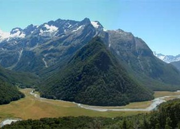
Continue along the track for another kilometre where a bridge crosses the burn and there are the first glimpses into the Routeburn Flats. The track skirts the flats within the boundary of the beech forest for another kilometre with the occasional glance through the trees to the surrounding mountains. Those people heading for Routeburn Flats Hut will head straight on at the next junction. The hut is about 5 minutes away and provides a good spot for lunch. Even if you are going to skip going to the hut, it is a good idea to walk through the forest fringe to have a look over the flats, along the North Branch of the Route Burn and up at the falls. If you are staying at the Routeburn Flats Hut then the afternoon can be filled in with a stroll up the North Branch starting with a knee-deep crossing of the Left Branch. It takes about 20 minutes to get to a couple of small waterfalls where there are good camping sites (and free!). You can follow the valley even further for a couple of hours on a lightly used track that is variously marked (poles, tree markers and cairns)..
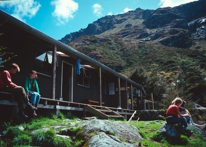
The track quickly and steeply gains 200m from the junction by a direct course up the slopes. It then settles down for an easy traverse across the slopes with 2 major streams crossed by bridges. The first is Israeli Creek which is named after an Israeli couple who got lost coming over a nearby untracked pass and spent some time on a ledge above the creek before being found. Emily Creek is next and has a sturdy wooden bridge across it - just right for a gander up the creek and out across the flats. However there is an even better viewpoint a hundred metres further on where the track crosses a bare slip. Take a little care on the way there since the track traverses an unstable bluff. After the slip the route turns uphill again and becomes rocky underfoot. The sound of the falls is now distinct before you turn a last corner and see a hut in front of you. This is the private hut for the guided walkers. The Routeburn Falls Hut is the other one to your right with the better views from its porch.
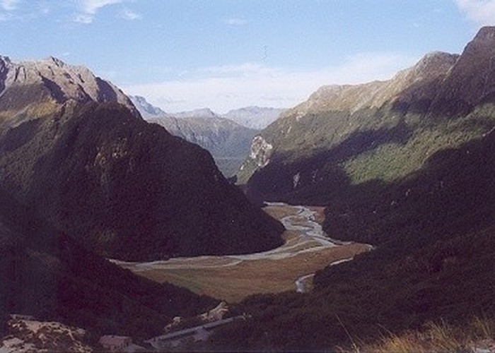
Have a rest, make yourself comfortable in the hut and then have a wander around. There are a number of waterfalls to look at as the burn drops over the edge of Harris Basin and cascades into a rocky gorge behind the hut. There are good views from the little knob a few metres past the helicopter pad, especially down to the flats, 300m below. The photo at the top of the page is taken from just above the hut and has Mt. Earnslaw left of centre poking around the shoulder of the ridge climbing to Mt. Momus.
| Routeburn Falls to Lake Mackenzie |
The morning starts off with a steepish 10 minute climb straight up from the hut to the edge of the Harris Basin on a rocky track. This is another chance to have a look at the waterfalls on the burn. At the basin edge, turn around to have a last look down to the Routeburn Flats. Looking ahead there is a spectacular ridge climbing to Mt. Ocean (1848m) to your left. Don't worry as the track heads towards the cliffs - it soon curves around to the right and into the basin.
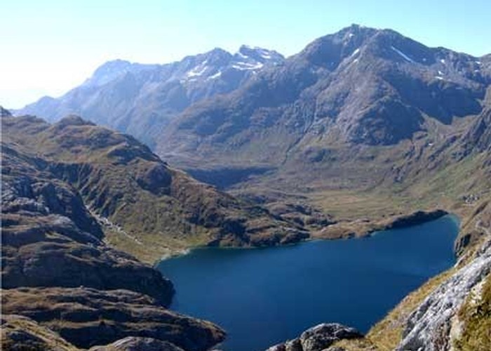
In about a kilometre you cross over a bridge and into the heart of the basin (marked by a patch of boardwalk protecting the fragile alpine vegetation). The pass is obvious ahead with a series of waterfalls cascading from the hidden Lake Harris into the basin. The track swings through snowgrass to the side of the basin, crosses a stream and begins a gentle climb up the basin sides heading towards a point above the lake outlet. Just above the outlet the path wanders through a cleft rock providing a bit of shelter to put on more clothing if needed and then up to a bluff where there are great views back across the basin and into the Routeburn Valley. More vigorous climbing follows as the track clambers to the top of the bluffs ringing Lake Harris and starts to squeeze its way along the vertical slopes to the saddle.
The waters of the lake below you will either be a deep blue. a slate gray or blinding white, depending on the weather (fine, raining or winter). On the saddle itself (1277m, a comfortable 277 metres above the hut) the hidden valley of the Left Branch (of the Route Burn) can be seen cutting north across the lake and into the Serpentine Range. There is another lake up there - Lake Wilson - nestled under Mt. Erebus (1983m). The saddle has a sprinkling of tiny tarns hidden in its folds.
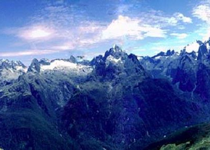
The track turns away from the lake and descends a bit down to the sturdy A-frame of Harris Shelter. The shelter has a toilet attached to the back. You cannot stay overnight here which would be very uncomfortable anyway. The backdrop to the shelter is the stunning Darran Range. Mt. Madeline (2537m) is the large flat topped peak to the north with the highest summit in the range just behind it - Mt. Tutoko at 2746m. There is a well-trodden path from the shelter heading up Conical Hill (1515m) where there are great all-around views. Allow 1-2 hours for the round trip. Note that the clear start of the path is a bit deceptive since it becomes less clear when the route becomes a straight slog up the slopes of the hill.
Have lunch at the shelter and then head south steeply down into a gully. The track soon starts to traverse across the exposed Hollyford face with the deep Hollyford valley to your right and steep slopes to your left. On a clear day you can have a look forward to Key Summit and may notice the zigzag track leading up to it from the track between Lake Howden and The Divide. At one point a flight of wooden steps takes the track over a tiny bluff. Just as the track rounds a spur about a kilometre from the shelter, the Deadman's Track falls 920m down into the Hollyford valley to a point just up the road from Gunn's Camp (a useful, but steep, emergency exit route). The nastiest bit of the track is a narrow sidle under bluffs but this is only for under 100 metres. Another 2 and a half kilometres brings the bridge across Potter's Creek which is a good spot for a break and a sip of mountain water. The track then climbs out onto a ridge where there is a good view down into the valley with the roofs of Gunn's Camp below (museum, accommodation and shop) and into the lower valley down towards Martin's Bay.
The track now swings north-west into the basin of Lake Mackenzie and climbs slightly. At the head of the basin is the fine peak of Emily Peak (1820m). The hut (and its bunkhouse) is now visible at the near end of the hourglass-shaped lake. The hut for the guided walkers can also be seen about 100 metres further away from the lake. The track continues towards the far end of the lake before making a couple of lazy zigzags 250m down a steep slope and heading back to the near end. The track enters bush above the end of the lake - pause here to have a look up at the bluffs that the diversion up the basin avoids. Lots of moss-encrusted trees entertain you for the last 500 metres to the hut.
If you have any energy left then a walk up the lake along a rough track rewards you with good views of the beautiful Emily Peak. There is a small grassy area that is suitable for camping.
| Lake Mackenzie to Lake Howden and the Divide |
This is another fairly easy day in fine weather. However I travelled it in torrential rain with a forecast of an 8 hour period of 25mm (about an inch) falling an hour being well met. Thus every unbridged creek or trickle of water crossed was quite a challenge with many thigh deep fordings through rushing waters. The main track passes under the Earland Falls but I gave up on this and took the flood route when the spray from the falls blasted on me like the exhaust from a jet engine. However such conditions are usually short-lived and people who remained at the hut for another 5 hours found the going much easier.
Head south from the hut across a short grass flat containing the camping site and a private hut. The track then enters the bush and climbs steadily for about 150m to a bridge over Roaring Creek. From then on the track sidles across the slopes keeping mostly within the forest margin with mountain beech around you and a few excursions into tussock clearings. The track crosses an unbridged tributary of Roaring Creek and then enters "The Orchard" 2.5 kilometres from the hut. This is a natural clearing containing a scattering of ribbonwood trees that resemble fruit trees (even though the main fruit seen is lichen). There are good views of the Upper Hollyford Valley and the Earland Falls.
The track wanders around Sunny Creek for another 2 kilometres with the sounds of the falls ever closer until the track joins the foot of the Earland Falls. On a fine day this is a great spot for lunch. On a rainy day you may have to take the flood route which is signposted about 100 metres before the falls. This thin track which looks more like a drainage channel drops down about 50m to a sturdy bridge. After the bridge the route climbs abruptly back to the main track. When I went up it it was like climbing a waterfall but the route may have been changed to be less wet in the rain.
The track is now enclosed in forest rich in ferns and shrubs. About a kilometre from the falls there is a small viewpoint to the north all the way up the Hollyford Valley to Lake McKerrow. The track descends gently for another 2 kilometres down to Lake Howden and its hut. There is no camping at the hut (a large split-level structure with 28 bunks and gas) but there is a camping site at the far end of the lake (20 minutes away).
A short climb of 120m through moss-clad beech forest then brings a junction with the Key Summit side-track in 15 minutes. This zigzags for 10 minutes up to Key Summit (919m) where a 30 minute nature walk loops past tarns and over many boardwalks (guides to the walk are in a stand at the start). The summit is worth the diversion with good views into 3 river catchments - the Greenstone, Eglinton and Hollyford - and their surrounding mountains. Back at the junction, the Divide with its shelter, the Milford Road and transport back to Te Anau and Queenstown are 40 minutes away.