The Kaweka Main Range - a NS traverse
Kaimanawa Forest Park, Kaweka Forest Park
- 5 – 10 days one way
- Easy/medium
A Kaimanawa-Kaweka traverse from Rangataiki to the Gentle Annie (Napier-Taihape) summit.
5-10 days of good track-tramping through the beech & manuka forest, vividly coloured sub-alpine ridges and barren rocky tops of the Kaimanawa and Kaweka Range.
This route formed one leg of my 44 day walk from East Cape to Wellington - part of an East Cape to West Cape project. But it is a walk well worth-while on it's own.
Probably, it offers the most variety in one place of the whole trip, and with the well maintained tracks and frequent huts of this range was certainly the easiest.
|
Walking time
|
5 – 10 days |
|---|---|
|
Type
|
One way
|
|
Grade
|
Easy/medium
Note that this trip involved an exposed walk over the 1700m+tops of the Kawekas. A well marked poled route, but very challenging in bad weather. Some off-track, bush-route sections are included here, but tracked alternatives exist. Grades explained
|
|
Bookings
|
No bookings — open access
No — open access
|
|
Starts
|
Rangataiki Tavern, SH5 (coming from Whirinaki) or Clements Mill Rd to walk just this segment |
|---|---|
|
Ends
|
Gentle Annie Summit, Napier-Taihape Rd (or Kurikapango / Lakes roadends if you avoid the route over Te Iringa) |
|
Maps
|
NZTopo50-BH37
NZTopo50-BJ37 |
|
Altitude
|
580m
–
1,724m
Altitude change 1,144m
|
.
Rangitaiki Tavern to Clements Mill / Te Iringa Track roadend. 24km road bash
If you’re coming from the Whirinaki, there’s a less-than-interesting 24km walk along the state highway (10km) and Taharua / Clements Mill Rd to the start of the Te Iringa Track. I’d stayed a few nights at the Rangitaiki Tavern and the owner was happy to run me to the roadend, so I avoided this walk.
There is a good, basic campsite at the Te Iringa track start, for those that need it.
Clements Mill Rd to Oamaru Hut (Te Iringa Track) – platformed tramping track, 16.5km, 4hrs
Coincidentally, both the first and last peaks of this trip bear the same name: Te Iringa.
The Te Iringa Track is signposted, starting about 5km up Clements Mill Rd. There’s a campsite and carpark at the start. The bush is a complete change from the Whirinaki. Mature beech trees cover the flats, dim light dappling an open forest floor carpeted in beech leaves beneath. Robins are evident for the first time in the trip, practicing their scales from branches above, and hoping you disturb something tasty. The track too is a welcome change: a broad, 2m wide benched track, well cut and well marked. After a kilometer-or-so of warm-up on the flats, the track begins to climb, rising with the ridge. Benched into the face, zigzagging where going gets steep, it is easy, fast travel. A couple of kilometers into the climb, the track passes through a grassy clearing – the site of the former Te Iringa Hut, now gone. There’s no obvious water here, so be warned if you were thinking of camping.
Soon after the beech is left behind and the ridgeline becomes scrubby. The highpoint of the track is 1160m, but the climb has been so gentle, you’d hardly have realised you’d gained 400m from the road. From there the track continues to sidle, dropping back into mature beech, and finally reaching Tiki Tiki Stream. 2hrs
A good, well-used campsite exists just before the first stream, but it’s another 2km to the swingbridge across the main Kaipo river (more campsites on the far side of the bridge. If you're lucky: blue ducks in the water below).
From the bridge, there’s another 7km of travel along river terraces to reach the Oamaru Hut. For the most part this is a broad track, cool and shaded though mature beech forest. The river meanders nearby: sometimes visible, sometimes not, banks lined with tall toetoe.
Shortly before the hut this comes to a sudden end: the shaded bush stopping on a sharp, ruiled line to be replaced by open scrubby tussock flats. 500m further downriver Oamaru Hut sits on a terrace at the confluence of the Oamaru and Kaipo – looking downriver over scrub to distant (felled) pineforest.
Oamaru hut is a busy spot – occupied 1 night in 3 on average. There are a huge number of fly-in hunters, despite being so close to the road. The alternative access route from Poronui Station (downriver) is a poled route on the scrubby banks and is signposted 3-4 DOC hours. The Oamaru river below is deep & clean and good for a dip.
Oamaru Hut to Otore Biv (via Otorehinaiti Saddle). Track (6km, 2hr) then route (5km, 2hr).
Otore Biv lies in the clearing just south of Otorehinaiti Saddle, at the head of the Harkness. There is no reason you couldn’t instead follow the track up the Oamaru and all the way to Boyd Lodge and head to Tussock Hut that way, however, the following route is far shorter and quicker, though off-track, and takes in this little-visited DOC biv.
The stroll upstream from Oamaru Hut is easy, tussock flats alternating with bands of scrub – a well traveled, poled track. After 3km it reaches the bushedge, where a typical Kaweka 1.5m-wide highway through the bush starts. From the bushedge it’s a further 3km to the confluence with the Otorehiniti Stream. The track is 100m north of the river at the confluence, so keep an eye on your map to pick out the spot you need to drop to the creek and cross.
There are good, well-used campsites at the Oamaru/Otore confluence. Ignore old permolat markers heading east at the confluence – they appear to sidle terraces on the south side of the Oamaru, heading downstream. The Otore valley is narrow at first, but soon opens up – good tramping up river flats and terraces, beech leaves and moss underfoot. Navigation is simple – following the main stream to where it swings due south towards the saddle. The gradient increases 1km from the saddle, and the flats disappear, but it is still good open beech forest, and easy walking, sidling the valleyside. 500m from the saddle, there is a final fork, not shown on the map. We climb the mossy slip between the two forks, heading due south towards the saddle, emerging onto a wide plateau of beech which rises gently to the saddle itself. There is some flagging tape here marking the way, but a bearing of due south would suffice.
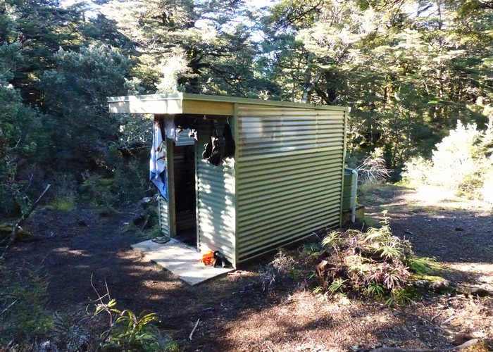
The Otore clearing is open – a mixture of marsh and tussock. The small Otore Biv is tucked away on the south-west side. There is 1 bunk, but no mattress, a water tank and a cooking bench. Space for a tent has been cleared next to the biv.
Otore Biv to Tussock Hut. Route, poled nearer the hut. 1hr, 3.5km
Heading south from Otore we sidle the valley on the west side of the creek. The bush has become scrubbier below the clearing and it is slow going. Several side-creeks, each in it’s own steep-sided gully, add additional challenges. Finally, sticking 150m-or-so from the creek, we emerge into the open tussock flats of the upper Harkness. The first 200m of the 'clearing' is thick with thigh-high scrub, and painful going. However, angling downriver and towards the creek, to where we can see good tussock, we soon reach good going. A creek joins from the east, and below it we pick up Warratahs and a narrow foot-worn track – the route from Mangatainoka Hut to Tussck Hut. The track leads down the valley, later climbing the western face. Finally, it swings west where the bush ends, over the low ridge and heads briefly up the side-valley to reach Tussock Hut.
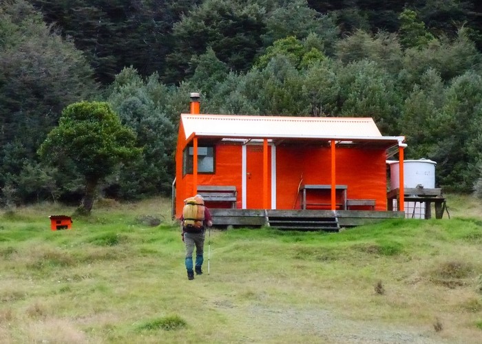
Tussock – our first Kaweka Hut – is true to the Kaweka form. A well-refurbished 6-bunk hut with a large covered deck round two sides. Tank water and sink on the deck, woodburner inside. Facing west across the tussock-covered valley, it’s a lovely spot in the western sun on a clear evening. There was a 12-pack of speights in the creek below when I passed through - only missing a sign saying free to a good home!
Tussock Hut to Harkness Hut – 7km, 2hrs, tramping tracks, several crossings of the Harkness Stream – easy in all but high flows.
The head of the Harkness at Tussock Hut lives up to the hut's name – a broad, gentle, V of a valley, clad in golden tussock. The track crosses the trickle of a stream and sidles the western face. The valley becomes slowly scrubbier as we head downstream – tussock becoming low scrub , later rising to waist height. The poled track changes from a foot-worn slot between tussocks to a full 1.5m-wide, cut Kaweka track. The gentle valleysides become steeper and rocky, and finally the track abandons efforts to sidle and drops to the Harkness River – now a couple of meters wide. Some 20 crossing follow – most of which can be hopped across with dry feet intact, but near the end there’s one which always catches me out. Fill your boots!
The track junction for the turnoff to Harkness Hut is signposted, and another broad Kaweka track heads up the north-east fork towards the hut, crossing the creek another 4 times. You can see the hut clearing on the northern slopes ahead, where tussock valley transitions back to beech. It’s a brief rocky scramble up the track to the hut, some 40m out of the valleyfloor.
Harkness is another standard forestry 6-bunker, pimped up in Kaweka style. Lagged and lined, a large deck across the front, woodburner and sink fitted - a comfortable spot. On a cold morning, with frost coating everything in the valley floor below, you appreciate that you made that last climb to this warmer spot.
Harkness Hut to Te Puke Hut. Track, 4km, 1.5hrs, 500m climb
From Harkness we continue along the central Kaweka highway. To warm-up there’s an easy 800m section along the valley floor, but then the climb starts. The broad track climbs steadily up the meandering ridgeline, reaching exposed tops 1km before the hut. The tops route is poled and clear.
A junction with a well-trodden track, heading north from the summit, is not marked on maps or signposted. However, it appears to lead off along the tops towards Mangatainoka Hut.
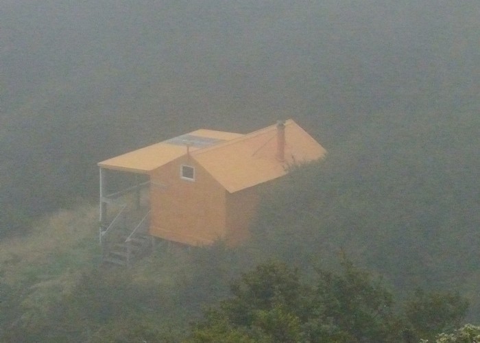
Te Puke Hut nestles in a beech-covered basin at the head of a small sidecreek on the southern side of the ridgeline - 100m off the track. The junction is signposted. The hut is another standard 6-bunker, lined and insulated, with a Kaweka-style deck across the front. It is at over 1400m, and catches only morning sun in winter, and was a cold spot when I visited for lunch. I’d say that it would warm up nicely, however, with the fire lit.
Te Puke Hut to Mangaturutu Hut, 8km, 2hrs, poled route / cut track.
From Te Puke the track spends a lot of time on an exposed, bare ridgeline, dropping in between to long, flat saddles where stunted beech trees lap over the tops - at the limit of their range. In late summer, the whistles of sika serenade me from the faces below. There are no major climbs, but lots of short ups and downs over each peak. The tops sections are poled, and the bush sections well cut, so it is easy tramping, but exposed.
Finally, the narrow ridgeline broadens to wide, marshy tops – climbing, slowly drying as they rise, to reach the track junction on the flat summit. Mangaturutu Hut is 600m along the NW fork – the track dropping 60m through a band of beech as it commences it's descent along another narrow ridge.
Mangaturutu Hut is tucked in a small beech basin, on the sheltered north-side of the ridge. It looks out north, with views all the way to Mt Edgecumbe (Putauaki) above Whakatane. Not having received the standard Kaweka makeover it remains a stock NZFS 6-bunk hut with an open fire. Most trampers seem to bypass the hut, and it receives far fewer visitors than Te Puke or Venison Tops. Most use comes from fly-in hunters.
Mangaturutu Hut to Tira Lodge / Venison Tops Hut. 4km, 1.5 hrs
It looks a simple 4km stroll along the tops from Mangaturutu to Venison Tops. Yeah, right!
Returning to the track junction at the summit above Mangaturutu, the poled track to Venison Tops runs south over the open tops – easy going for 500m, when the low saddle(s) to Venison Tops open out below you. The track drops to a narrow ridgeline, losing 200m to the first saddle, climbing again 100m-or-so to cross each of two intermediate nipples above the low ridgeline. Beyond the third saddle, the track makes a final, steady 300m climb to reach the bushedge at Venison Tops Hut. It’s a well marked, well cut track, and I shouldn’t complain, but there’s a lot of up and down for just four horizontal kilometers.
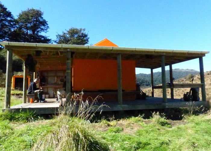
Tira Lodge / Venison Tops Hut is a 3-room affair in the style of Triplex or Waipawa Forks. A central kitchen with a fire, and two 6-bunk bunkrooms off either side. The bunks are steel mesh, and sag - and the heat from the fire never reaches them. But otherwise it’s a nice hut, and hey – the kitchen’s warm.
Tira Lodge / Venison Tops Hut to Ballard Hut. Track, 6km, 1hr45.
The huts are coming thick and fast now. From Tira to Ballard, the track drops steeply to a beech-covered saddle, where it idles flat for a couple of kilometers before commencing its steady climb to Ballard. The 400m climb is continuous but good, the 1.5m wide cut track following the ridgeline as it weaves its way upwards towards the main Kaweka tops. Things become steeper and stonier once the bushedge is passed, and we climb through red clay-pan hollows in a landscape painted orange, yellow, grey by the sub-alpine plants and lichens of the Kawekas. Climbing further, the clay-pan is slowly superseded by bare fine stones, the colours of the sub-alpines by a diminishing scattering of grey-gold tussock. Until finally, nothing remains but bare rock and scree.
A large cairn on the summit marks the turnoff to Ballard Hut, accompanied by a standard steel-plate Kaweka signpost. At a jog, it takes just 10 minutes to descend the 200 vertical meters from the summit to Ballard Hut – I was just down for a nosy, and left the pack at the summit. The route is not marked or poled, but is fairly obvious.
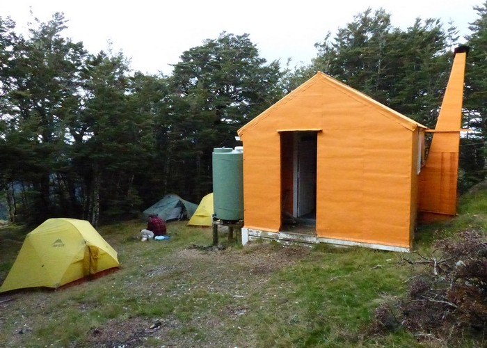
Ballard hut is tucked almost out of sight, just inside the beech on the saddle below. It is an almost-standard 4-bunk NZFS hut. The open fire has been replaced with a stove, and the place is lined, but there are no fancy Kaweka decks here. Water is from a tank outside,
Ballard Hut to Kaweka J summit, 7km, 2h15. Poled route
The 200m climb back up from Ballard to the ridgeline takes slightly more than the 10 minutes of the descent, even without a pack. The good news is that once back on the summit there is no real climbing left to reach the main Kaweka ridgeline, 1km to the east at Whetu.
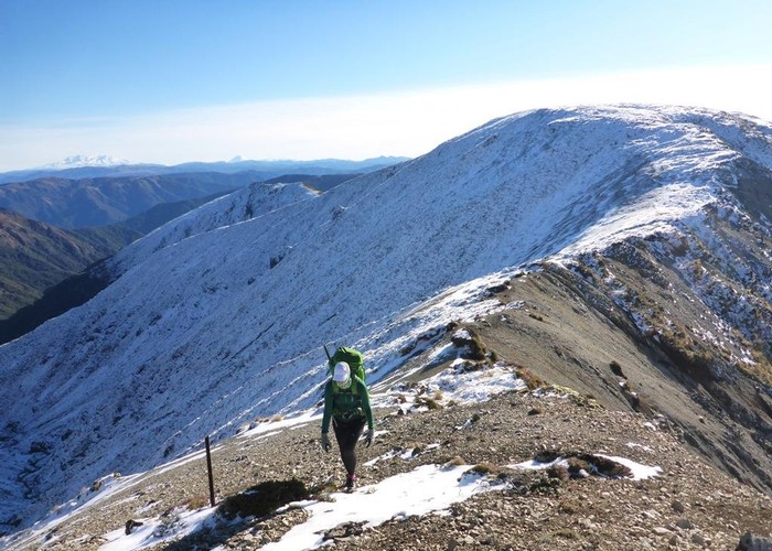
Heading south along the main range, the poled route rises and falls with the ridgeline as it crosses 2 minor peaks and intervening saddles. Next comes a long, tiring slog up North Kaweka to the mast – only 120m above the saddle, but it feels like more. Beyond there the ridge broadens to flat, stony tops, devoid of any vegetation. Frost action has made wave patterns in the gravel, and in places sorted the rocks into polygons of larger stones. On a good day, all three major volcanoes are visible to the west: Ruapehu, Ngarahoe, and in the far distance Taranaki. To the east, on a really clear day, a distinct grey shape beyond the Uruwera range can only be Hikurangi. This place truly feels like the top of the world. 2km further south, a memorial cairn marks the summit of Kaweka J, the highest peak in the park.
===
The normal route from here is to continue south along the main range, over Mad Dog hill, dropping optionally to Studholme Saddle Hut, and then making a long arc west and south along the range to reach Kiwi Saddle Hut. I detail this route below from past visits, but on my north-island traverse, I opted instead to see some new country and avoid the weekend crowds. I dropped east from Kaweka J to Dominie Biv, Makahu Saddle Hut, turning south along the east Kaweka plateau for a night at Mackintosh Hut. The next day I continued south, passing the former Kaweka Hut site, and then climbed back onto the main range over Kurikapango high-point to reach the junction 1km east of Kiwi Saddle Hut from where I rejoined the route detailed below, dropping to Cameron Hut.
===
Kaweka J to Studholme Saddle Hut, poled route. 3km, 45 mins
From Kaweka J south the poled route drops slowly mainly sticking to the barren ridgeline, sometime sidling the west face, until it reaches Mad Dog Hill.
Dropping steeply off Mad Dog, vegetation finally returns, though the route sticks to open scree-faces beside it where it can.
You can stay on the main range all the way south to Kiwi Saddle if you want. Alternatively: a track, signposted Studholm Saddle Hut, drops due south off the main range a few hundered meters below the Mad Dog summit, heading down the spur to the east of the hut. Shortly before coming level with the hut, the track cuts steeply down the west face of the spur to reach a small copse of beech in the valley floor below. Following the creek downriver it soon reaches the 6-bunk Studholme Saddle Hut.
Continuing down the stream to the next forks, the smaller dog-box Studholme Saddle Biv is on your left, just up the eastern fork. It is scheduled for removal, so may not be there much longer, however.
Studholme Saddle Hut to Kiwi Saddle Hut, 9km, 3hrs, poled route.
From Studholm Biv, a rough, unmarked track cuts due east up the spur to pt 1406, where it rejoins the main ridgeline.
For some reason the ridge between Mad Dog and Kaiarahi (the next peak south from pt 1406) catches the worst of the south-westerly. I have had days that I can barely stand on this ridgeline, but could lay a map on the ground on the Kaweka summit without it so much as moving.
Following the arc of the main range first south off pt 1406, then west to Kaiarahi, and finally WNW from there, we continue to drop steadily. Side tracks lead to McIntosh, The Tits, The Cook’s Horn (a somewhat phallic outcrop next to The Tits) and The Rogue. How that lot got past the Lands & Surveys naming board I don’t know! However, sticking to the main range, we finally drop back into beech forest, and soon after encounter the unusual Castle Camp. Effectively a greenhouse built from transparent plastic sheeting over a timber frame, this ‘shelter’ is probably most handy for its water tank, though you could stay inside if you bring your own sleeping mat, or camp on cleared platforms nearby.
Beyond Castle Camp the ridge rises again, returning from beech forest onto the subalpine tops. It is a further 4km along the exposed tussock, hebe and lichen covered ridgeline before to the next beech-clad saddle, and Kiwi Saddle Hut.
Kiwi Saddle Hut is a tramping club hut built and maintained by Herataunga Tramping Club. It is open to the public and a donation of $5 per person is requested by post. It is a tidy hut, sleeping 8 on 2 platforms. There’s the usual woodburner and water tank, and a handy ‘air-lock’ at the front providing a wet-room to disrobe out of the weather before you enter the hut itself.
===
Kiwi Saddle Hut to Cameron Hut. Track, very steep in places. 7km, 2.5hrs
Form Kiwi Saddle the track south climbs 300m to the unnamed summit and the junction with the Cameron Hut track. The climb is steady, not too steep on solid, fine stone – and is probably a nice walk on a good day. But I’m not sure what a nice day would be. Under a hot sun – it’s heat reflecting off the baked stones, not a breath of a breeze -it is climbing the wall of an oven. On a winter’s night, snow curling over the ridgeline, blown by in a bitter south-westerly – the hut can’t come soon enough. And in the more usual fog and rain it’s just a plod to another, unseen summit. You can’t please some people, eh?
The summit is marked by a rare sight in the Kawekas – a wooden signpost. Maybe they rain out of steel plate that year. Dropping west towards Cameron Hut, its just 100m to the bushedge, and some shelter from the elements. After a brief drop, the ridgeline meanders around at about 1100m for an age. Climbing, falling over numerous small peaks, but generally getting no closer to the silver thread of the Ngaruroro visible (on a good day) 1000m below at the base of the deep gorge. The south face of the valleyside is scarred by numerous slips, the vegetation back to that sparse manuka so typical of the Kawekas; the north thicker, more stable, a solid canopy of beech. A track forks off north to Kiwi Mouth Hut (the fastest way out of that hut, if the Kiwi Stream is up) and later we swing south, but still do not start to drop.
Finally, the track veers sharply left off the final peak of the ridgeline, and we commence a precipitous descent to the river. The broad Kaweka highway is gone – the track benched and cut only by the passing of feet – zigzagging its way down a narrow, crumbling slips and chutes. The descent goes on for ever – in and out of scree chutes, brief sidles between them. The out onto clay-pan faces – fine in the dry, but lethal after rain, ‘like butter spread on steel plate’. And still the river, far below.
Slowly, eventually, features on the valley-floor resolve into objects. We’re dropping to a semi-circular flat, trapped between a sweeping curve of the river and the steep sides of the gorge. A large, circular clearing in the middle of the flat – at first guessed to be the hut site - becomes a dry lakebed. The sea of green becomes tall, mature manuka – growing some 10m tall in this flat, protected spot.
We finally hit the valley floor, knees trembling. A short track leads to a junction: Kiwi Mouth & Te Iringa right, Kurikapango left. No mention of Cameron Hut.
Cameron turns out to be left, the track heading briefly downriver before swinging south towards the point of the peninsula. Cameron Hut sits in a moss-carpeted clearing 50m back from the river.
Cameron is a standard 6-bunk SF70 forestry hut. Open fire, water from the river. The tall manuka which surround the hut are dwarfed by the 1000m, bluffs and slips of the gorge above. Bare, crumbling rock – dwarfed, twisted manuka clinging to any foothold. The Ngarurora is wonderful, when clear and low. Deep, crystal clear pools - and a refreshing swim.
Cameron Hut to Gentle Annie Summit – Te Iringa Track. Unmaintained (by DOC) route / track, partially over private land. 7km, 3hrs
DOC notices in Cameron Hut start that all land south of the river is private. The lines on old 1” maps, however, seem to show the park boundary running down the spur from Te Iringa to the hut - meaning that the ridge, and land downriver is crown-owned. However, once back home, consulting WAMS shows that the face opposite is indeed all private, though your reach a rectangle of DOC land once on the ridgeline above, and remain on public land from there to the Gentle Annie summit. As such, the landowner’s permission is probably required for the scrubby first part of this route.
Returning to the back of the flats, and taking the track turning upriver, the day starts with a pleasant 1km stroll across the flat. The swingbridge over the river is gone, but it can be waded in normal flows. The track opposite is another matter – marked with permolat, but completely overgrown. Following it upriver, there is a signpost to Te Iringa, hidden there in the scrub, but no sign of any track to go with it. Instead we push through the thick manuka until we find the spur marked on the map.
The first 100m up the spur is scrubby and tough, but soon the scrub retreats off the crumbling gravel ridgeline, and going improves. There’s a good ground trail, laid down by many deer and a few boots, and soon regular permolat markers appear. The track is steep, but not precipitous like the descent to Cameron. The scrub stops, just as the gradient lessens, and the track becomes a series of short ascents to knobs, with flat sections in between. Scrub again becomes more common, but there’s a well traveled track, and someone is clearly cutting it occasionally. Finally the spur tops-out into tussock, and we sidle/climb to the main ridgeline beyond. All up a steady 800m climb, but reasonable going once out of the manuka scrub at its base.
Once on the main ridge there’s an excellent track running south-east. No markers, but a well used, well worn ground trail – eroded down over a meter deep in places. This heads SE towards the Gentle Annie road summit.
At pt1191 the track swings east (a small campspot in the beech copse at its head, no water). It drops rapidly, the track well cut and well worn through increasing scrub. Swinging south, it heads over a small outlying knob, then drops, zigzagging the face to the road-summit visible below. Vegetation becomes more verdant and aggressive as we near the road, and the track becomes overgrown – the cutters clearly losing the battle in these lower altitudes. But still an easy track to walk.
We emerge though claypan to the old roadbed, which we follow 20m to reach the summit of the current highway. No sign marks the track, just a route left for those in the know.
==
Well, I know the Kawekas officially finish at the Taruarau River some 15km further south. But we’re standing here on a sealed road, and there’s 8 days of uninterrupted walking beyond it all the way to Woodville. So forgive me if I leave the Kaweka section of this routeguide here, and commence – on the other side of the highway – with the Ruahiunes.
The Kawekas have offered much. Travel of excellent tracks through beech and manuka forest. Golden tussock, and the array or reds, yellows, greens of the hebe and lichen covered ridges. Barren tops of frost-sorted rock. And what views: summits that look out to 3 coastlines. All the major volcanoes, at first barren rock, later dressed in snow.
They have brought with them too the pressing presence of humanity. Busy, noisy huts all down the main range. Parties, too, met on the track – some with a words, some with a nod, some heads down and silence. Some offer advice, a couple criticism, others a brew, back-steaks and cake. The cities of Hawkes Bay, their weekend hunters and trampers, have come as a shock. For 20 days from East Cape to Rangataiki, these ranges have been mine alone, but here I have had to learn to share again. And fair enough too.
Especially if I get backsteaks and cake!