Nearby
Kerin Forks
Picton to Aspiring
GPX file
•
Distance: 347m away
An aborted alpine traverse. Picton to West Cape, but aborted at Aspiring due to real world emergencies back home. Posted ...
More ▶︎

Haast to The Divide
GPX file
•
Distance: 359m away
Andrew Barker's traverse 2009. From Pleasant Flat in the Haast to The Divide via Mt Aspiring National Park.
More ▶︎
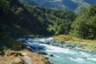
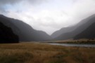
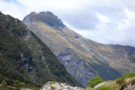
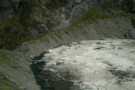
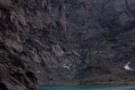
Where do rivers come from?
Photograph
•
Distance: 361m away
Wilkin North Branch toward upper lakes
More ▶︎
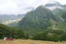
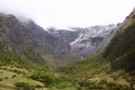
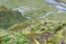
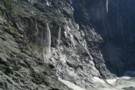
Track to North Branch lakes
Photograph
•
Distance: 361m away
Shortly before reaching the Disappearing Tarn
More ▶︎
Wilkin Valley Track
Track
•
2 – 5 days. Easy/medium. Return by the same track.
•
Distance: 361m away
This stunning track is commonly tramped in conjunction with the Gillespie Pass Circuit or with the Rabbit Pass/East Matukituki traverse, ...
More ▶︎
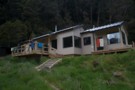
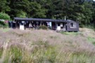
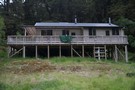
Kerin Forks Hut
Hut
•
Serviced Hut (DOC). Capacity: 10.
•
Distance: 368m away
Kerin Forks Hut (10 bunks, wood-burning stove, firewood avail., tank water) is a spacious, comfortable hut at the back of ...
More ▶︎
Wilkins - Young (Gillespie Pass) Circuit
Track
•
3 – 4 days. Medium. One way.
•
Distance: 494m away
Crossing the Makarora river on foot to the Young valley. Ascending to Young Hut in the first day. 2nd Day ...
More ▶︎
The Newland Stream
Photograph
•
Distance: 2.5km away
Taken from the true left side of the Wilkin after a dangerous fording of the flooded Newland stream. Moirs guide ...
More ▶︎
New Siberia Hut
Photograph
•
Distance: 4.1km away
The new hut was built and completed by the end of November 2011. It's a lovely little hut and after ...
More ▶︎
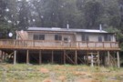
Siberia Hut
Photograph
•
Distance: 4.1km away
This is a popular hut on the Gillespie Pass circuit from the Young to the Wilkin.
More ▶︎
Siberia Hut
Hut
•
Serviced Hut (DOC). Capacity: 20.
•
Distance: 4.1km away
Popular hut in the Siberia Valley. Part of the Gillespie Pass circuit.
More ▶︎
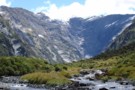
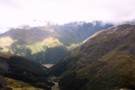
The Siberia Valley
Photograph
•
Distance: 4.1km away
This is looking downvalley from just below the Siberia hut. The Siberia airstrip is located right of frame across the ...
More ▶︎
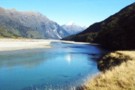
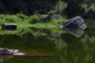
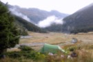
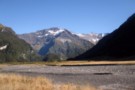
Wilkin River flats
Photograph
•
Distance: 4.5km away
Wilkin River flats, below Kevin Forks Hut.
More ▶︎
Mt Jumbo from Wonderland
Photograph
•
Distance: 6.6km away
View of Mt Jumbo from Wonderland valley
More ▶︎
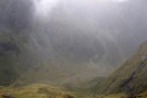
Crucible Valley
Photograph
•
Distance: 6.6km away
Having cleared the bushline this view is offered of the head of the valley. The morrain forms Crucible Lake.
More ▶︎
Camping in the Jumboland
Photograph
•
Distance: 6.6km away
After 8 hours slogging up the True left side of the flooded Wilkin it was time to stop for the ...
More ▶︎
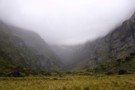
Head wall of Wonderland Valley
Photograph
•
Distance: 7.0km away
Taken in Mar 2006 after bush bashing up the true right of Wonderland stream. No trail just picking a way ...
More ▶︎
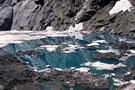
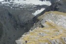
Icebergs in Crucible Lake
Photograph
•
Distance: 7.4km away
Taken January 24 2010, Crucible was full of bergs and avalanch debris this day.
More ▶︎
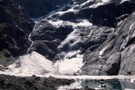
Avalanche at Crucible Lake
Photograph
•
Distance: 7.5km away
A crackling boom was followed by rumbling and a small 20-30 second avalanche of ice and snow came crashing down ...
More ▶︎
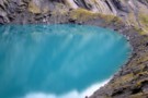
Crucible Lake 2
Photograph
•
Distance: 7.6km away
Crucible Lake located under Mt Alba often contains iceburgs but none were present this April.
More ▶︎
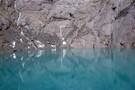
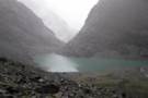
Crucible Lake
Photograph
•
Distance: 7.7km away
Taken from the Western end of the morrain, gives a good idea as to why the lake is named. Often ...
More ▶︎
Lake Crucible (trampers on moraine near outlet)
Photograph
•
Distance: 7.7km away
Wilkin Mar 05
More ▶︎
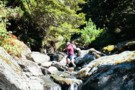
Walking on Air
Photograph
•
Distance: 7.7km away
Joseph (10 years old at the time) leaping across the stream on the way up to Crucible Lake, which is ...
More ▶︎
Gillespie Pass Circuit
Track
•
3 – 4 days. Medium. Loop track.
•
Distance: 7.7km away
This is a 3-4 day track that is located near Makarora at the head of Lake Wanaka. Being a loop ...
More ▶︎
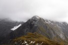
Gillespie Pass
Photograph
•
Distance: 7.7km away
Looking down at the Young side of the Pass.
More ▶︎

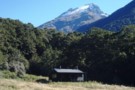
Young Hut
Hut
•
Serviced Hut (DOC). Capacity: 20.
•
Distance: 8.0km away
A newly built hut (2006) with stainless steel benches. A inside sink with tap from rain tank. 2 rooms, one ...
More ▶︎
Gillespie Stream and the Siberia from Gillespie Pass
Photograph
•
Distance: 8.8km away
Looking South West from the pass, the Gillespie Stream snakes its way down towards the Siberia Valley. The valley across ...
More ▶︎
The Gillespie Saddle
Photograph
•
Distance: 8.8km away
Taken from the hightest point of the Gillespie Pass track on point 1629 looking over the saddle towards point 1726. ...
More ▶︎
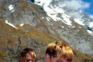
The boys, Gillespie Pass, Jan 2001
Photograph
•
Distance: 9.2km away
Aged 11 and 14, the lads proved remarkably resilient on the Wilkin/Young tramp, braving sandflies a the "Young Forks lunch ...
More ▶︎
Along way up
Photograph
•
Distance: 9.2km away
The track to Gillespie Pass climbs nearly verically towards the pass. This is looking back down into the Young Valley ...
More ▶︎
Mt Betsy Jane
Photograph
•
Distance: 9.4km away
The Top Flats of the Wilkin valley are dominated by this mountain which towers about Top Forks hut. Named after ...
More ▶︎
The Head of the Young Valley
Photograph
•
Distance: 9.6km away
The Head of the valley shortly before leaving the valley floor to begin the climb to Gillespie Pass up the ...
More ▶︎
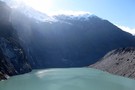
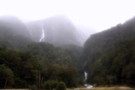
Lake Castalia
Photograph
•
Distance: 9.7km away
Completely ringed by rock walls, numerous waterfalls tumble off the towering Mercury Peak glaciers to feed Lake Castalia, the North ...
More ▶︎
Lake Castalia from the North
Photograph
•
Distance: 9.9km away
Sidling around the Eastern shore of the lake takes you into the upper reaches of the Castalia valley, a sea ...
More ▶︎