Nearby
Trout
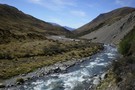
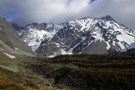
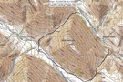
Cameron river view
Photograph
•
Distance: less than 100m away
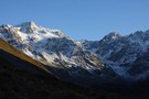
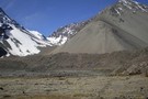
The main peaks of the Arrowsmith range, as seen from the middle Cameron valley, 2hrs from the road.
More ▶︎
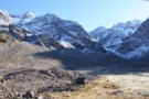
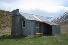
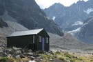
cameron hut
Photograph
•
Distance: less than 100m away
the peaks above the flats between the moraine walls at the head of the Cameron river, including the Cameron Hut. ...
More ▶︎
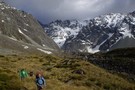
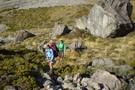
Departing Cameron Hut
Photograph
•
Distance: less than 100m away
Time to leave the head of the valley before the weather closes in.
More ▶︎
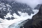
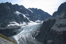
Cameron Glacier
Photograph
•
Distance: less than 100m away
Can be viewed an hour or two up behind the Cameron hut.
More ▶︎
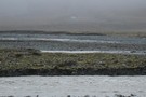
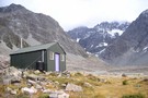
View from Cameron Hut
Photograph
•
Distance: less than 100m away
The area around Cameron Hut looks like an abandoned quarry the way the glaciers have moved and formed moraine.
More ▶︎
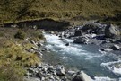
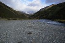
Cameron River
Photograph
•
Distance: less than 100m away
Ahead lies a climb to avoid the river gorge.
More ▶︎
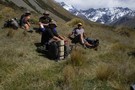
Resting Place
Photograph
•
Distance: less than 100m away
Taking a break on the way up Cameron valley.
More ▶︎
Big Stone
Photograph
•
Distance: less than 100m away
The scale of the surroundings can be hard to judge.
More ▶︎
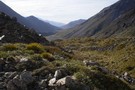
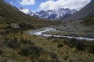
Down Cameron Valley.
Photograph
•
Distance: less than 100m away
Looking down the Cameron Valley from the true right. This was taken not far from the Cameron Hut, which gave ...
More ▶︎
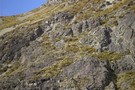
Tahr
Photograph
•
Distance: less than 100m away
There is rumoured to be Tahr in these mountains!
(They can be very difficult to spot)
More ▶︎
Beginning of Cameron valley and the Cameron River.
Photograph
•
Distance: less than 100m away
The Cameron river is located in the Wild Mans Brothers Range. At the top of the valley is the Arrowsmith ...
More ▶︎
The Arrowsmith Range
Photograph
•
Distance: less than 100m away
Looking up the Cameron valley at the Arrowsmith Range, The Twins are to the peaks to the right.
More ▶︎
Double Crossing of the Wild Man Brothers Range
Article
•
Distance: 2.6km away
A 3 day trip going from the head of the Cameron River in the Hakatere over the above range to ...
More ▶︎

Cameron upper valley
Photograph
•
Distance: 3.0km away
The upper Cameron valley showing the Cameron glacier and Arrowsmith range. taken March 2008.
More ▶︎
Top Hut (Te Kahui Kaupeka)
Hut
•
Basic Hut/Bivvy (DOC). Capacity: 10.
•
Distance: 3.2km away
Top hut in the upper South Branch of the Ashburton River.
10 bunk hut built 1958 by Mt Arrowsmith Station. Taken ...
More ▶︎
Top Hut (Te Kahui Kaupeka)
Photograph
•
Distance: 3.2km away
Top hut in the South Branch of the Ashburton River. taken 24-Oct-2011.
More ▶︎
Wild Man Hut
Hut
•
Private hut (PVT). Capacity: 4.
•
Distance: 3.3km away
Musterer's hut owned by Mt Arrowsmith Station. Used by hunters but the odd tramper stays as well. Doesn't seem to ...
More ▶︎
Ashburton Hut?
Photograph
•
Distance: 3.3km away
Ashburton hut(?) on the other side of the flooded South Branch of the Ashburton River. photo taken 26-Oct-2011.
More ▶︎
Ashburton Hut?
Hut
•
Basic Hut/Bivvy (PVT).
•
Distance: 3.3km away
Not sure if this really is called Ashburton hut, or what state it is in. I could see it on ...
More ▶︎
Wild Mans Brother circuit
Photograph
•
Distance: 3.8km away
A weekend circuit in former pastoral lease country from the Cameron to the head of the South Ashburton River via ...
More ▶︎
Wild Mans Brother Range Circuit II
Article
•
Distance: 4.7km away
A longer circuit of the range with a stay in a refurbished musterers' hut in the head of the South ...
More ▶︎
Cameron Hut (Rangitata/Rakaia)
Hut
•
Basic Hut/Bivvy (DOC). Capacity: 9.
•
Distance: 5.8km away
Located close to Arrowsmith Range at the head of the Cameron River valley. This is a Canterbury Mountaineering Club Hut, ...
More ▶︎
Cameron Hut
Photograph
•
Distance: 6.5km away
5-6 hours walking up the Cameron Valley, not far from Lake Heron.
More ▶︎
Hakatere Conservation Park
Place
•
Conservation Park. 600.00km2.
•
Distance: 7.1km away
This park protects high country between the Rakaia and Rangitata Rivers in the Ashburton Lakes District, Mid-Canterbury.
More ▶︎
Cameron Glacier
Photograph
•
Distance: 8.0km away
Cameron Glacier, Arrowsmith Range. taken March 2008.
More ▶︎
Boulder Col from Washbourne Ck to Jagged Stream
Article
•
Distance: 8.9km away
Nine hour circuit with good view of Reishek Glacier.
More ▶︎