Nearby
Waiau River
'Down in the Valley Below..."
Photograph
•
Distance: less than 100m away
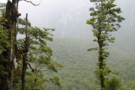
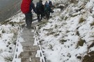
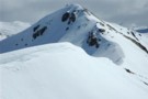
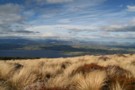
Hanging Valley from the switchbacks above. (Kepler Track)
More ▶︎
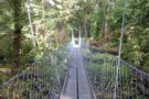
Swingbridge on the Kepler Track
Photograph
•
Distance: less than 100m away
The swingbridge crossed on the last day of the Kepler Track.
More ▶︎
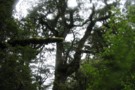
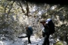
Beech Forest
Photograph
•
Distance: less than 100m away
Ancient, mossy, soaking wet Beech trees on the descent into the Iris Burn valley. My camera lens were wet(... yeah ...
More ▶︎
The Iris Burn Valley Pt.2
Photograph
•
Distance: less than 100m away
View up the Iris Burn valley, towards Iris Burn Waterfall.
More ▶︎
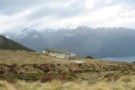
Motorau Hut
Photograph
•
Distance: less than 100m away
A view of Motorau hut (on Lake Manapouri) as you leave it to finish the Kepler Track.
More ▶︎
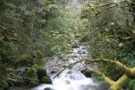
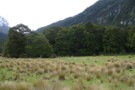
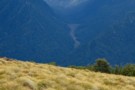
Iris Burn Valley
Photograph
•
Distance: less than 100m away
A pretty little snow-fed stream in the Iris Burn valley
More ▶︎
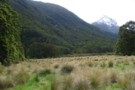
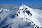
The Iris Burn Valley Pt.1
Photograph
•
Distance: less than 100m away
View up the valley, Spire Peak on the right, 1112m unnamed peak at extreme left.
More ▶︎
Luxmoore saddle
Photograph
•
Distance: less than 100m away
The ridgeline that the Kepler track hugs before it plunges to the Iris Burn valley below. It was pretty cold ...
More ▶︎

Great Walks Information
Article
•
Distance: less than 100m away
The DOC Great Walks are a set of premium tramping tracks throughout New Zealand.
More ▶︎
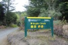
Kepler Track
Track
•
3 – 4 days. Easy/medium. Loop track.
•
Distance: less than 100m away
Popular loop track providing access to the mountains around Lake Te Anau.
More ▶︎
Brod Bay campsite
Campsite
•
Great Walks Campsite (DOC). 15 spaces.
•
Distance: 1.2km away
Campsite in beech forest on the shoreline of Lake Te Anau.
More ▶︎
Shallow Bay
Track
•
0 – 2 days. Easy. Return by the same track.
•
Distance: 1.4km away
Short and easy day or overnight walk to a hut just off the Kepler Track.
More ▶︎
Shallow Bay Hut
Hut
•
Standard Hut (DOC). Capacity: 6.
•
Distance: 1.4km away
Basically a big shed on the sandy shores of misty Manapouri. Situated beneath tall trees, it would be idyllic except ...
More ▶︎
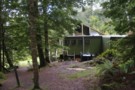
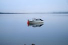
Shallow Bay Hut
Photograph
•
Distance: 1.4km away
A prime spot in winter when the mountain backdrop is covered in snow, reflected in Lake Manapouri. This was our ...
More ▶︎
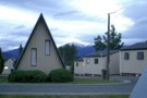
Lakeview Holiday Park, Te Anau
Photograph
•
Distance: 1.5km away
I know it's commercial, but this little beaut is well worth staying in. It's about 5 min walk out of ...
More ▶︎
The track is booked out? Try TrekWatch.net
Article
•
Distance: 1.5km away
SMS texts directly to your cellphone when a place becomes available. Free of charge!
More ▶︎
Te Anau
Place
•
Place.
•
Distance: 1.5km away
A town on the banks of Lake Te Anau, the South Island's largest lake. The town is close to Fiordland ...
More ▶︎
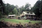
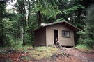
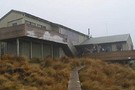
Moturau Hut
Photograph
•
Distance: 1.8km away
Moturau Hut is an ugly big barn in a clearing by Lake Manapouri built to house smelly tourists on the ...
More ▶︎
Walking, hiking, tramping in fjordland
Article
•
Distance: 2.8km away
“Done”(tick) the Kepler? Tackling the Dusky? . . . . . . . . . . . .
also @:
https://photos.google.com/?tab=mq&pageId=none&pli=1
More ▶︎
Kepler Track
Photograph
•
Distance: 3.4km away
First of the possible trailends for the Kepler Track, at Rainbow Reach.
More ▶︎
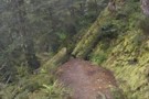
Bushline
Photograph
•
Distance: 3.9km away
November on the Kepler. Forced to return to Control Gates due to snow conditions between Luxmore and Iris Burn Huts.
More ▶︎
Hidden Lakes
Track
•
1 day. Easy. Return by the same track.
•
Distance: 5.2km away
Short walk past a series of lakes. Water access only.
More ▶︎
Mt Luxmore Hut
Hut
•
Great Walks Hut (DOC). Capacity: 55.
•
Distance: 5.8km away
On the Kepler track.
More ▶︎
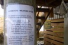
DoC Humour
Photograph
•
Distance: 5.9km away
Found at the Luxmore Hut, the tanks at the end of the hut are part of the sewage system...
More ▶︎
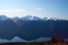
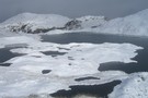
Murchison Mountains
Photograph
•
Distance: 6.3km away
A late August shot of the snow covered mountains across South Fiord from near the Mt Luxmore hut.
More ▶︎

Manapouri sunset
Photograph
•
Distance: 6.7km away
Beautiful sunset at the shore of Lake Manapouri after coming out of the Dusky track
More ▶︎
Luxmore Hut
Photograph
•
Distance: 6.8km away
Luxmore hut... isn't it beautiful. Really cosy and toasty warm inside... best place in the world on a cold, damp ...
More ▶︎
Kepler Track
Photograph
•
Distance: 6.8km away
Kepler Track between the Hanging Valley & Forest Burn Shelters, Sept 16, 2006
More ▶︎
Mt Luxmore in August
Photograph
•
Distance: 7.0km away
Taken from Point 1402, good snow conditions made for an easy crossing from Luxmores summit to here via the Eastern ...
More ▶︎
Misty Morning Reflections at Lake Te Anau
Photograph
•
Distance: 7.1km away
Its possible to walk from downtown Te Anau to the start of the Kepler track where along the way you ...
More ▶︎
Murchison Mountains
Photograph
•
Distance: 8.1km away
A view up the valley seperating Mt. Owen and Black Cone, from a point perhaps 30 minutes out of Luxmoore ...
More ▶︎
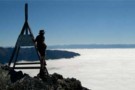
Mt Luxmoore trig
Photograph
•
Distance: 8.1km away
View over Lake Wanaka from Mt Luxmoore trig - a short detour on the Kepler Track. Sometimes what you don't ...
More ▶︎
Kepler Track
Photograph
•
Distance: 8.1km away
view from the first day of the track, after leaving the bushline behind
More ▶︎
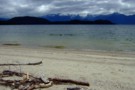
beach at Manapouri Lake
Photograph
•
Distance: 8.9km away
there are several sandy beaches on the last part of the Circle Track
More ▶︎
Manapouri Circle Track
GPX file
•
Distance: 8.9km away
I walked the track clockwise in November. Along the beach my GPS did some jumps, but the track is very ...
More ▶︎
Manapouri Circle Track
Track
•
Easy/medium. Loop track.
•
Distance: 8.9km away
Track goes through beech forest and along the Manapouri Lake and Waiau River. The track is well marked and cleared ...
More ▶︎
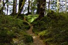
beech forest on Manapouri Circle Track
Photograph
•
Distance: 8.9km away
Photo taken on the climb to the top of the ridge
More ▶︎

Lake Manapouri
Photograph
•
Distance: 9.8km away
A cold, wet day with snowing above about 900m.
Made it to Motorau Hut, had a quick swim in the lake ...
More ▶︎