Nearby
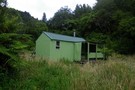
Descending into the Waikura
A Raukumara Crossing
Article
•
Distance: 488m away
The first leg of a trip from East Cape to West Cape via the main divide.
More ▶︎
Raukumara East-West Traverse
Track
•
5 – 12 days. Hard. One way.
•
Distance: 488m away
An east-west traverse of either the Raukumara range, or the entire East Cape. A minimum of 5-8 days in it's ...
More ▶︎
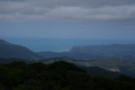
Taumaoteawhengaiao ridgeline - and the view towards Te Araroa
Photograph
•
Distance: 1.3km away
Taumaoteawhengaiao - the most memorable placename on the entire north island main range. A view at last after hours of ...
More ▶︎
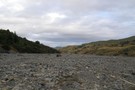
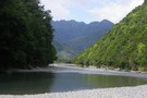
Waikura River
Photograph
•
Distance: 3.3km away
Waikura River below the Raukumara Forest park boundary. The Waikura is a LINZ-owner riverbed, so publicly accessible - but has ...
More ▶︎
Raukumara Forest Park
Place
•
Conservation Park. 1151.00km2.
•
Distance: 3.8km away
An area of isolated wilderness in the Eastern Bay of Plenty, featuring the famous Motu River and the Raukumara Wilderness ...
More ▶︎

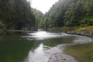
Kopuapounamu River
Photograph
•
Distance: 6.4km away
Finally is native bush - the Kopuapounamu River alternates between lush native bush and stark pine plantations and scrub as ...
More ▶︎
Waikura River below Te Kumi Station
Photograph
•
Distance: 8.7km away
Below the Te Kumi roadend at Te Kumi Station, the Waikura River flows back out of farmland and returns to ...
More ▶︎