
A year ago we visited the exquisitely pretty Stanleyvale and stayed in the renovated, rustic hut situated on the fringe of rowan trees amid gooseberry bushes at the foot of a low hill. We got there from Scotties Hut in the Edwards, from there up to Charlies Saddle and up the Stanley via the Racecourse. In the evening we hoofed it down to L.Guyon but ran out of time or enthusiasm after a long day so never actually reached the hut. It was the official goose hunting w/e so plenty of Elmer Fudd types were out with their decoys down by the lake which fooled me but not Frank of course as they had replicated poses. I started to suspect something when they didn’t fly away on our approach.
Since then I’d been keen to concoct a circuit involving the lake and hoping to stay in the hut there which has a good reputation. Of course this area is pretty well patronized by hunters and the MTB fraternity so we haven’t held out much chance at being able to find a bunk.
We drove to the road that takes you to Maling Pass and on the way saw plenty of vehicles parked all over the place, some with cycle racks. We hoped they were doing the St James cycleway as a one dayer. We had planned to save ourselves about a 1km walk to where Sandy Stream comes out to the old 4WD track that leads over Maling Pass but not long after the turn-off there was a locked gate with a combination so we parked there. By the time we left the car it was 10 to 3 and the sign indicated a walk of about 6 hours.
On the way to the pass, I reminisced about a trip I’d done with the PTC to Princess Lake and how the snow had been soft enough to get to the summit as well. I’d underestimated the amount of snow so was chuffed to be able to follow Bill’s (first to the top of the hill Bill) plugged steps all the way up. Frank said he’d be happy to go climb it sometime with me. So that’s another trip planned.
I anticipated the walk over the pass to be tedious and had the iPod plugged in. In actual fact it was a lovely walk with fantastic views of the Spenser Range, the east face of Una in particular which Frank and I had climbed a few years ago with the CMC. Frank had broken his rib coming off avalanche debris onto the warmed rocks when he fell through the soft snow. He’d impressed the group by walking over the pass at his usual pace carrying his heavy mountaineering pack. We eyeballed the routes we’d taken intensively and compared memories. Conditions had been similar to this weekend with the lower set of bluffs above the basin just beginning to lose their condition with ice softening and water running underneath. This time we could see a bergshrund at the base of the bluffs.
It took us 2 ¼ hours to get to the junction between our route and where Te Araroa runs from Waiau Pass rather than the stated 4 hours so that was a cue for a lovely rest and snack on bench-like barricades which prevent motorized vehicles from travelling any further down the Waiau. A couple of vehicles were parked at this point, I guess they were fisher folk but we didn’t see them. We carried on and were delighted to see a herd of the famed St James horses on the opposite bank. They looked beautifully proportioned and very healthy. There were no foals among them.
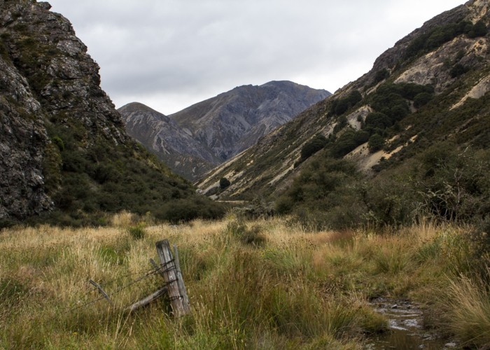
Not long after this we arrived at the turn off to L.Guyon. We travelled up a slight rise and were rewarded with the blue vista of the lake. After a short time through beech forest examining the terrain for campsites we approached the hut at the edge of a large clearing up from the lake. Folks were out enjoying the pleasant evening but not the voracious sandflies. It was now a bit after 7pm. They were a group of MTBers going over the Racecourse the next day. We had met a couple of them the previous w/e in Casey Hut and I’d told them about the Cow Stream hot pool they would be passing close to. After going over the Racecourse they might be keen for a dip…
I went in and admired the 4 bunk hut. The bunks looked narrow but I was impressed with the look of the woodstove. We agreed it would be nice to do a snow-shoeing trip in winter sometime when bicycles would be guaranteed to be absent. Frank asked me if I’d spotted a good place to camp but I suggested we carry on a bit further to Stanleyvale Hut to see if there was room for us there. as I didn't fancy a long evening batting off sandflies. So we continued along the lake and over a gentle rise to the plateau where the hut stood. I remarked on the prettiness of the scene but Frank was non-committal. However his previous entry in the hut book had said, “beautiful spot”.
By the time we got there it was 20 past 8pm. We realized we were entering the abode of a frequent flier with all the gear left there and possum skin frames stored under the bunk. Sean from Karamea had just gone out the previous day leaving things reasonably clean and tidy. My feet felt exhausted with the repetitiveness of the cycle trail walking and my dearest inclination would have been to go straight to bed and be served dinner. However this wasn’t going to happen so I went off a circuitous route through the beech forest and groves of gooseberries to get water from the final creek we’d crossed, forgetting there was a lovely little stream right next to the hut.
I prepared a meal of tuna Thai green curry and rice using Sean’s big pot and hit the hay. I was too tired to contemplate climbing the high step ladder to the top bunk so slept on 2 mattresses on the floor. It was a mild night. I got up at towards 8am and by 9.30 we had the MTB visitors while I was trimming the briars round the door and other vegetation. This close growth will only serve to destroy the hut. We set off initially in the direction of Fowler Pass. The head of the Stanley was as attractive as the vale. We divergedfrom the track and followed an old subtle 4WD track through stands of matagouri on terraces.
Eventually the 4WD track petered out but reappeared at an incised side stream choked with matagouri. Mercifully there was a wide passage where the vegetation had never regained its foothold. Then we sidled on narrow terraces on the true right following strong animal trails. I figured they were maintained by pigs as the place was destocked a few years ago. Travel was easy and pleasant. We dropped down to the stream where our route was to lead us up to a saddle via a gentle zig-zagging spur with a final sidle before its summit. This was the ideal spot to enjoy lunch in the sunshine.
We studied the terrain and the map and worked out the best height to sidle around to the saddle as there were fingers of gullies ending around this altitude and I was keen to avoid unpleasant scrambles on shattered rock. Verdant tussocks indicated a good place to sidle. Going up we managed to avoid hebe and other patches of scrub in slippery tussock by following small leads of earthen scree for the most part. I had heat rash round my ankles for the previous hot day so had my skin exposed and was keen to avoid scratching the skin on scrub and picked my way carefully. We sidled across the slippery tussock now interspersed with mats of welcome textured celmisia. The sidle was pretty much spot on, avoiding unnecessary height gain and steep slopes on the saddle side of the final spur.
From here on the terrain was broad and gentle, covered in treacherous carpet grass which accounted for the greenness we’d seen en route. We dropped down a bit on the Sandy Stream side for a snack and loafed in the sun, discussing the best route down to the stream. The map indicated the gentlest terrain being the stream bed that runs from the saddle down to Sandy Stream but this was a bouldery staircase I wanted to avoid. Over to the true right close contours at 2 points indicated bluffs. A possible high sidle and gradual descent to the right would avoid these. We decided to stick close to the stream and descend by the seat of our pants. Fortunately there was fine scree abounding in the scrub which gave us a continuous fast line down to the stream.
We agreed for this circuit it would be better to ascend the saddle in the opposite direction as height gain was much less and the descent to the head of Stanley Stream good with similar leads of scree. However if we’d done this we would have had the extra height gain to Malings Pass and the long walk out of a 4WD road bash on the final day without the magnificent views ahead we’d enjoyed going in. This direction would work well for a circuit of Sandy Stream, the head of the Stanley and Fowler Pass though.
Sandy Stream was a gentle little stream snaking its way through its valley. Travel looked to be very pleasant. At the first side stream I got on a little animal trail and crossed the heaped banks of shingled debris flow. To my delight I noticed hundreds of blooming fragrant penwiper plants and shared this with Frank. We turned the corner of the valley and saw a manmade structure which turned out to be a fireplace of waratahs in the boulders. Nearby there were iron pipes lying around. I wondered if this was the structure of an old musterers camp. We continued down the stream, me in front criss-crossing bits of stream to avoid swampy bits.
I heard the kek-kek-kek of a falcon and sure enough, one was perched on a boulder alarming away. We stopped nearby for yet another snack while it made a couple of forays over our heads which we discouraged with our walking sticks. Frank got tired of my swamp-avoiding boulder hopping strategies across the river and mutinied, sticking to the true left. The river then led to the far true right of the valley, dropping down to form escarpments while the true left formed an attractive mosaiced plateau of mossy vegetation, tussock and small scrub. Frank headed to the 4WD road and waited for me on a rise overlooking the cycle bridge that crossed Sandy Stream. This bridge makes sense as the water is infested around here with didyma. It was not far to the car from here then off to Jolly Jacks for a beautifully cooked dinner before the drive home.