
We heard there was actually a hut in this area where huts were absent, then it was confirmed from reading an edition of "Antics". However Frank was cagey about crossing the middle branch of the Wainakarua river and said we should delay doing a trip in this cold southern region until September at least.
Staircase Hut is tucked in down on the south-eastern side of a high point along the Staircase Spur. In the meantime a second hut, Kahikatea Lodge, was built by another branch of the NZDA - North Otago nearby, only 3km away as the crow flies.
We looked at options for a tramp and discounted other options and then Frank suggested Kahikatea Lodge. I was trying to figure out how far along the road we could drive and left an answerphone message with the guys who manage Staircase after being unable to talk to the contact for the lodge. Pat Chave rang back and sounded very approachable. He mentioned that there was a vacancy on the next day from now so I rang off and suggested we stay at Staircase as well as visiting the new lodge, then rang back and booked our 2 bunks.
We'd read horror stories from people who'd gone up what turned out to be the wrong spur and had hell missions getting to the hut. Pat reassured us that the track to the hut was well-marked. He was also keen for us to contact him after the trip to give feedback on hut and track conditions. He talked about the DoC track being well-marked. I figured that was probably the access track that goes from Pt 399 down to the river and that the track up to and along the spur was maintained by others.
We drove down to Herbert and turned off to drive along Mt Misery Rd to the carpark at Pt 399. Another car was there and we thought it was probably the 2 people who'd stayed at the hut the previous night. Annoyingly. the DoC sign at the carpark served only to caution hunters that other people might be in the area, instead of informing people that it was the track to Staircase Hut and giving an estimated time for the trip in to the hut.
We set off down the hill on a very wide gentle former 4WD track that turned off and steepened, getting narrower. The young couple were coming out even though it was around 3pm. We figured they'd probably needed to catch up on their sleep and have a lazy start to the day after the walk in the day before. They reassured us that it was easy to spot the climb out of the river and told us to cross the river and then travel on the true right.
They said they were fairly new to tramping so we didn't ask them how long it had taken them to get there. Pat had asked us if we were fit and said it normally took 4-5 hours to get to the hut. We arrived at the river and were delighted to be able to boulderhop across and keep our boots dry. There was an unmarked trail along the bank and the river was quite attractive. After 8 minutes and travelling 600m we saw a big DoC triangle indicating the start of the climb out.
It was initally steep travel though fairly open forested slopes with very little understory. The trees were useful to grab as we pushed ourselves up the hill to the main spur. An understory of particularly catching scrub developed - maybe a mingimingi or coprosma type of vegetation and then there were occasional windfalls. We cleared and flicked stuff off the track, leaving bigger stuff for the next day.
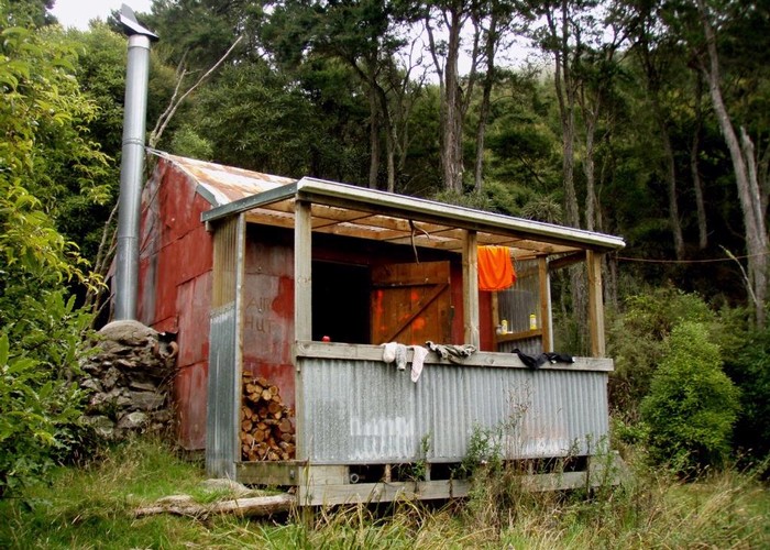
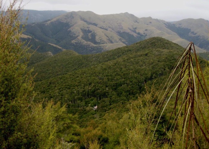
There were also lovely open areas of forest with carpets of moss. We moved along through a forest composed of a unique mix of lancewoods and kanuka and stopped at Pt 499 for a snack. We could see mist brushing the tops at around 600m a.s.l. so there wasn't much of a view. We carried on and came to a grassy hilltop then skirted the 600m contour line and dropped down to the saddle, descending through forest to emerge in a small clearing festooned in flowering clematis and the hut.
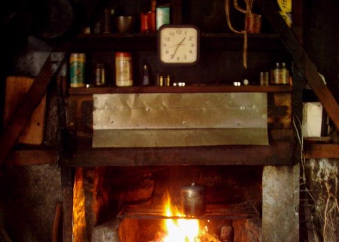
First thing was to check the wood supply. The neophytes had gathered a few damp sticks and thrown them in the woodshed. There was a cabbage tree there so I pulled dry leaves from it for kindling. Frank went off and cut down a few dead standing kanuka trees to stock up the wood shed. The door on the hut ominously gave an alias of 'Smoky Hut' but when we studied the hut book we saw that a few years ago some wonderful person had sorted the problem out with a corrugated iron surround and a very tall flue.
I knew there'd be a frypan and oil in this hut so had taken a packet of falafel mix for our dinner. I got the fire easily going with a bundle of cabbage tree leaves and kindling left by the incumbents, piled on a stack of bigger stuff and then Frank's bigger stuff came on stream. We had a nice evening with my reading the 2016 edition of 'Antics', and got the crossword out in it except for one clue - the name of the mud monster at the Welcome Flat mud pools - maybe it was the orca!
The next day we too had a lazy start but cleaned, tidied, swept, disposed of rubbish and Frank sawed up his logs and stacked them in squares on the porch, giving what was in the woodshed a chance to dry out properly. I exhumed from outside the woodshed smaller bits concealed under cabbage leaves and chucked them in there to stay dry (duh). We were intrigued by the DoC sign which mentioned a 6 hour track back to the carpark via Table Top. The hut owners/maintainers come in via Mt Fortune, 3 and a half kms travel along the tops to the south-west.
We got away when it was nearly lunchtime, climbing up to the grassy high point to have lunch in the sun. We'd only seen one lot of sign on the way in but near this spot was a tongue of grass sloping down to the west, which would be good grazing for deer and feral sheep. As we went, we resumed our track clearing efforts but Frank kept his saws on his pack as he'd spent enough time sawing with his firewood contribution. I used my secateurs to cut through slender lancewoods that had fallen across the track along with bigger windfalls.
We dropped down easily to the river and climbed briskly and steadily up to the carpark. We got there even later than the young couple had as we taken longer due to the track work en route. We decided to stay the night so found a sheltered and level spot tucked in the forest but did our cooking and dining in the car where it was sunny.
The next day we set off in the car to look at getting to Government Hill, a high point in Herbert Forest that is on our list of Top of the Topo's to be ascended. Frank was concerned that if we parked our car at the locked gate, the cockies of Glencoe would assume we were hunting in their neighbour's forest so we decided instead to visit Kahikatea Lodge and come back another time to go up Government Hill and the other high point on the adjoining map - Puketapu. Glencoe Campsite deserved a look see too as there were indications of tracks through there - possibly leading to Government Hill itself.