
MetService showed a gap in between areas of rain in the Eastern Foothills in Canterbury. We were due to climb something with a decent height gain so Frank suggested a climb of Mt Taylor followed by a traverse of the Mt Somers Range along to Quaker Saddle then down to the plateau east of the Manuka Range. We’ve summitted Mt Taylor twice as a day trip when it was covered in snow and been up to Quaker Saddle three times so we were looking forward to joining the dots.
Rain was forecast for Sunday afternoon and on Monday as well but Frank thought there was a good chance of a window of opportunity in this area. We packed and drove to the Lake Emily carpark and drove on along the 4WD track before Frank decided with the rain forecast it was too risky to take the chance of parking the car at the 4WD car park as the track was very rutted so could be greasy on our drive out, leading to our being stuck in a rut. A friendly and chatty fisher stopped to say hi and I told her about L. Emily being home to brook char, an American salmonid.
We walked along the road on a surprisingly cool December afternoon passing a few merinos grazing. A sign at the 4WD car park informed us Manuka Hut was an hour and a half’s walk away but Frank scoffed at this. It was interesting to see how much the ground trail had formed over the low south-east terminus of Emily Hill through the scrub since we’d last been there. Rose briars were blooming and very pretty they were. I was wearing my sandals as I had a bruised toenail from a recent trip so was spelling my roomier pair of boots until the climb.
I was starting to get hungry as we dropped down into the Stour Valley where a stiffer wind blew. We walked along a former farm 4WD track then left it to round the foot of the Manuka Range and cross the West Branch of the Stour to where the hut was nestled in a sheltered spot from the Nor’westers. No one home, lucky us. DoC had been taking good care of the hut with a new padlock on the door, and recently fixed sash windows. It was relatively clean and tidy e.g. no dirty pots or much rubbish. If it had been occupied, we would have continued on to Double Hut but there is a risk that that would be full with the Te Araroa traffic and being so near to the road end at L. Heron. It had indeed only taken us an hour to get to Manuka Hut.
I cooked dinner which was a disappointing seaweed flavoured (what was I thinking) risotto with added too ‘spicy’ chorizo. Not a good mix and overcooked and too dry. Next time I’ll have another flavour and add oil and parmesan after cooking. Lights out and we slept until after 7am. We woke to wind – not a promising omen for a climb. After breakfast we packed our gear away and hid it in the hut as it gets a lot of visitors with being so close to the road. A previous occupant had had a lot of his gear stolen according to the hut book.
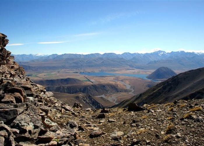
We walked along to the Double Hut and spent a few minutes there checking the hut book. A party had recently climbed Mt Taylor and then continued to Old Man Peak. The walk up the Swin River took longer than I recalled. The distinctive terminus of the spur that takes you to the summit of Mt Taylor was soon in sight. This had given us some grief a couple of years ago when Frank had had heatstroke and been planning to descend via the very end of it, a former way of descent on our previous climbs. Erosion by the river had made it into a steep vicious shredding bedrock of schist and I had suggested dropping off via some scrubby slope. It was now obvious that this slope was the way up and someone had marked the drop-off point from the spur to the river with a large cairn.
We stopped for a good drink of water and took on more for the climb. I changed from sandals into boots. It was initially quite steep so I took it quietly. I’d got hungry soon after we started climbing and planned to stop at the first high point, a castellated outcrop – Pt 1766 -, where we could find shelter from the wind. The going was hard and I was thinking there was no way I would be able to climb to the summit but I continued, one foot after another. Eventually we got close so I changed course from vegetated scree to rock-strewn slopes, looking for the sheltered side of the outcrop, but starting to suspect there was no lee side to the towering rocks as they were all on the downhill, windward side.
Fortunately I found a wee cave and suggested we shelter there. I was pretty cold from the wind and had foolishly neglected to put on my gloves. However I needed to eat bare-handed so just wolfed down the fillings that would normally be put on crackers as time was the issue with the cold. Frank said we’d done well to get to the outcrop and we were pleased when we realized we’d done the first half of the climb. We decided to carry on to at least regain the ridge and go to the next viewpoint.
It was a lot less steep from here on so we found it less tiring. The wind got stronger though. Sometimes we could travel on the southern side, lee to the ridge. Gusts would pick up and push us uphill, enabling me to actually run with them. The cooler weather made the climb less tiring although bracing against the gusts was tiring in itself. I was traveling more quickly than Frank and found sheltered spots off the ridge to wait for him.
Eventually we got higher than Boundary Col – where we had crossed into the Swin from the Northern Ashburton a couple of years ago and then we only had the final section of the ridge and a slight change of direction for the last 130m to reach the summit. The wind picked up. I recalled the two previous ascents on calm spring days when nearly the entire climb had been in snow. Just before the summit I stopped, braced against a very strong wind and waited for Frank as there was another summit of similar height not far away. Was this the real summit? No reply so I slipped around the back of the nearer high point as there was no way I’d want to tackle the summit directly with the wind wanting to push us into the outcrops en route.
I lay down in shelter and saw the summit trig pole a few metres away. This was close enough for me, having stood at that pole twice already. Frank joined me and we had a high 5 moment. We reviewed our options for the descent and decided the safest route in the wind gusts would be to retrace our route back into the Swin as this terrain was known. He warned me that we’d have to crawl off the summit back into the wind to regain our approach ridge and I thought this would be unnecessary caution but he was right. There was no way I was going to present much air between my torso and the ground to the wind so hands and knees it was for a few metres until the wind lessened.
We traveled quickly down the slopes back into the Swin, taking only one and a half hours. I no longer concerned myself with keeping my feet dry but at each point we managed to find boulders to hop across on. Frank got a bit behind and then I found out he’d stood on a boulder which had fallen down, dropping him onto another, landing on the back of his thigh. He said the bone-strengthening measures he’d been taking were working as he didn’t break his thigh with the fall. We carried on, skipping crossing to Double Hut. We took a direct line to the 4WD track which we met half a km north of Seagull Lake by travelling through low matagouri. It was fast easy travel in boots and saved us another 500m.
As we rounded the northern end of the Manuka Range, I announced I could smell the hut. I explained this meant smoke from the chimney but it didn’t appear to be smoking now. Frank would soon smell it too. We crossed the Stour opposite the hut and saw the bolt slid open, indicating occupancy. A lone Kiwi SOBO, Jason who was friendly and enjoyed company as he hadn’t had much en route. He’d had a very long day as he’d come from Comyn Hut but had done a 14km deviation by Double Hut when he’d taken the track heading west to Lake Heron, into the sun, instead of the track south to Manuka Hut. How he’d make that mistake for 7km escapes me. The day before he’d walked 26km on the road before going from Glenrock to Comyns Hut – another long day.
It appeared as though Jason had lit the fire to cook his rice for his evening meal. He kindly offered to relight it for ours but we were happy with our gas cooker and the ambient temperature of the mild evening. He was off to bed by 10pm and slipped up effortlessly to the top bunk like a monkey. I wondered if his B.Sc was in physical education…
In the morning he packed early and left for another long day to the Potts River bridge where he was hoping to hitch to Geraldine. I emptied the fireplace of 3 full buckets of ashes even though someone claimed they’d emptied it 2 months before. I also swept and dusted and removed rubbish as we had only a short walk out to the car. Frank swept a bit and helped me put the collected firewood into the woodshed as leaving it by the fire only enables wastrels to light an unnecessary fire.
We walked out and enjoyed a lunch stop with a good vista to the west. I pointed out that we were sitting a few metres from a shortcut which Frank queried the existence and practicality of but on returning home, the GPS trail indicated he’d actually chosen this way coming in! We carried on then stopped for a while to watch sheep being rounded up. Cattle in the same paddock were unperturbed by dogs and sheep running around. I had a good freshen up in the stream by the gate and we drove on to the Salmon Tales café only to find it closes early on a Monday afternoon. A good bit of exercise with sore legs the next day from bracing against the wind gusts though not as sore as Frank’s thigh.