Comments
-
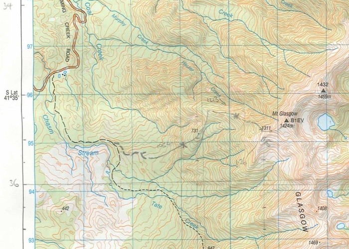
Roger1 I hiked up to the summit of Mt Glasgow on 4 February 2012. The map diagram indicates the approximate position of the route taken. It took us (2 gents aged in early 40s & 60s with average but reasonable fitness for age) 5 hours 30 minutes up and 4 hours 30 minutes to come down. The weather conditions on the day were favourable.
In a casual conversation with someone from DOC, he mentioned that they stopped maintaining the track about 3 years ago due to low usage.
This would be recommended for experienced trampers only with good route finding skills
Route description describing how we reached the summit
From Charming Creek Rd, walk approximately 2km up the 4 wheel drive track to where an un-signposted track is visible on your left. This appears to be an ex 4wd track but is overgrown to the point where it would only be possible to walk. Follow this for approximately 750m to 1km until the ex 4wd peters out into a marked route only. The route is regularly marked by pink ribbons attached to trees or shrubs right up to the bushline. There were several windfalls along the way and it can take a while to pick up the next ribbon beyond a windfall. We were totally reliant on the ribbons as the former track is very overgrown and no longer obvious for almost all its length. Above the bush line, the route is not marked. Follow the ridgeline up to where the spot height of 1311m appears on the map (there is a survey mark pipe in the ground here cut off at about 30cm above ground level). From here, keep following the ridge to the north east to reach the summit of Mt Glasgow. Great views from the summit!
13 March 2012
ID 7772
About this photograph
License
87 views in the past year (7 per month).

