Old Coach Rd - Ohakune
Tongariro National Park
- 4 hr – 6 hr one way
- Easy
Part of the NZ cycleway recently opened by John Key. However parts of this track are quite muddy, even on foot. Follows an old coach road and parts of the main trunk railway line that was realigned in the 1980s
|
Walking time
|
0 – 1 day
4 hr – 6 hr
|
|---|---|
|
Distance
|
12.9km |
|
Type
|
One way
|
|
Grade
|
Easy |
|
Bookings
|
No bookings — open access
No — open access
|
|
Starts
|
Horopito |
|---|---|
|
Ends
|
Marshalls Rd, Ohakune |
|
Maps
|
NZTopo50-BJ34
|
|
Altitude
|
621m
–
765m
Altitude change 144m
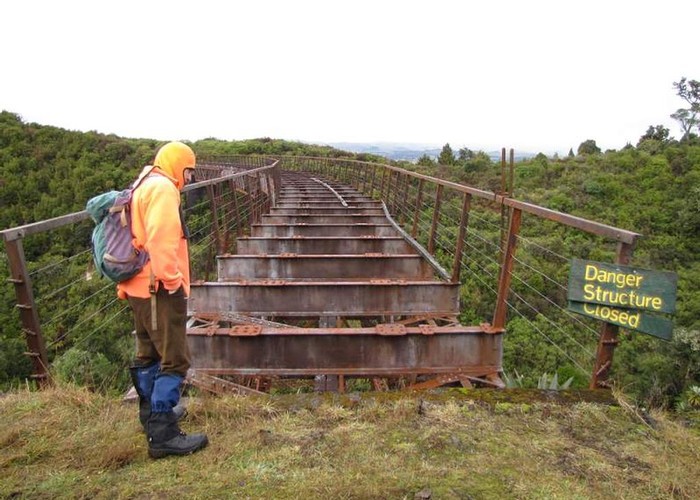
|
It is probably more logical to start this track at the Ohakune end as there is a well developed carpark on Marshalls Rd and good signage. However I will do this description from the Horopito end as this is the way we did it. Presently signage is a little inadequate at the Horopito end but hopefully this will change soon as the track is still under active development. Turn off State Hwy 4 at Horopito just south of the car wreckers yard and veer right where the road veers across a stream and down Clyde's Access. This seems to be the old railway embankment and there is a rather unwelcoming sign at one of the first gates. We drove right to the bush edge along the access but as there are a number of gates it might be just as easy to walk. At the bush edge a sign welcomes you to Tongariro National Park and it is an easy mater of just following the well formed track. Soon after beginning the remains of the supports of a railway bridge are seen on the right. The railwaywas realigned in the 1980s and remnants of the old alignment are seen along the way. The track soon crosses the actual main trunk railway line. There aren't many trains nowadays but do take care. Just past here the impressive Taonui viaduct comes into view. The decking has been removed from this and crossing it would be a rather dangerous option. One day, maybe, this will be restored. Our track takes the safer option of descending to the valley and following upstream for a while before resuming the traverse towards Ohakune. At the time we did it the track was very muddy here but work is in progress so hopefully it will have improved. The track then winds uneventfully around the hillside with occasional views out onto the Ohakune countryside. You may notice from time to time the old cobblestones underneath the mud and leaf litter. These were laid to provide all weather traction for stage coaches before the railway came through here. Eventually the two Hapuawhenua viaducts comes into view. The old one up the valley with its newer counterpart to the south. The track takes a detour to cross the old viaduct which has been fully restored for foot traffic. You then have the choice of returning the same way or descending into the valley. Either way you come back to the point where you first viewed the viaducts. The track then goes under the new viaduct, around a headland to the end of a short tunnel. You can walk through the tunnel but the far end is blocked by a grill. The final part of the track descends gently to the Marshalls Rd carpark passing a number of interpretation panels which provide information about the history of the area.