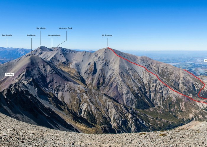
Mt Torlesse
Korowai/Torlesse Tussocklands Park
- 4 hr – 8 hr return via same track
- Easy/medium
Noteworthy peak east of Porters Pass.
|
Walking time
|
0 – 1 day
4 hr – 8 hr
|
|---|---|
|
Distance
|
17.0km |
|
Type
|
Return via same track
|
|
Grade
|
Easy/medium
In snow, best to take ice axe and crampons Grades explained
|
|
Bookings
|
No bookings — open access
No — open access
|
|
Starts
|
Big Pine by Kowai River |
|---|---|
|
Maps
|
NZTopo50-BW21
|
|
Altitude
|
630m
–
1,961m
Altitude change 1,331m
|
Drive through ford to locked gate 200m distant. Travel on 4WD track except for brief deviation to riverbed to avoid old slip. At Foggy Stream stay in riverbed on true right initially, crossing the now tiny Kowai River tributary towards the visible hut upvalley (1hr).
From the hut, drop down the little track behind and cross by the old debris measurement apparatus to gain the obvious spur which leads directly to the summit. It will take anything from 1 and a half hours to 3 hours to gain the summit via well defined spurs, faces and bypass screes. The screes are not difficult to ascend or descend for that matter and a path has formed in most places.
Halfway up the hill you may observe at a tussocked and vegetated place, 2 low walls. These are remnants of Frank and my bivvying spots where we slept out on the mountain on a beautiful warm night with nearby snow for a source for water in a gentle easterly.
You may prefer to descend different ways such as the SE spur from the summit to a low saddle that leads to the head of the NE tributary of Kowai River from the hut. This way is not as quick when there is no snow as there is some tiresome large talus to negotiate. You can also descend via the scree directly south of the summit where there is a waterfall to bypass. I wouldn't choose this way in avalanche season as it would be a nasty terrain trap. Alternatively you can descend to the delightful valley upstream of the hut via a bifurcation of the spur you ascended at the 1060m contour. I recall this way did have the odd fibreglass wand to guide you and consolidate passage. Descent should take 1 to 1 and a half hours to the hut.
Be sure to leave gates as you find them. Permission is not necessary from precedent established by the Macmillans of Brookdale to travel on the flat lowlands on the approach. At the time of writing, the manager for the wealthy American landowner had attempted to stock the valleyhead with cattle for the winter on 8/5/10 but the cattle had immediately moved a bit downstream, leaving their calling cards all the way down the stream - yuk!