
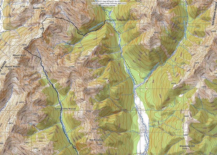
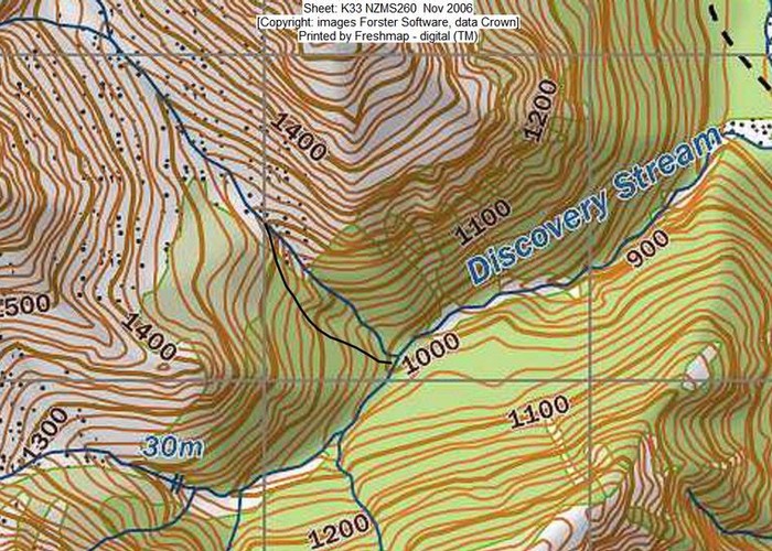
Frank and I did 3 reccies for this trip but on the first 2 forays, had to turn back when the weather clagged in. On the 3rd foray, time management was too poor to allow us to do the complete traverse from Walker Pass in one day. Instead we settled for an abbreviated version of descending from point 1705 (NZMG E2404734 N5810630) to the col south east of this and then into the NW tributary of Discovery Stream. From here we had descended the stream to where it steepened above a waterfall. We then had sidled out on the true right, crossed a gully and descended through steep beech forest with scrubby undergrowth to rejoin it at the confluence with the SW tributary. We noted the NW tributary had several waterfalls in it that we had bypassed with this deviation.
When we had gained Point 1705 via a steep but easily climbed pretty gully, we had had a good look for the next foray. We noted that it made more sense to sidle directly to a col along the ridge (NZMG E2404221 N5810633) from the bottom of the gully, to avoid unnecessary height gain and steep terrain. The route to this col looked straightforward via scree and tussock interspersed with fragrant celmisia and other fell plants. We also noted to our delight that a visible, slightly benched animal trail led from this col into the western basin between the bluffs of the ridge line and a lower band below.
So last weekend (14/03/09) we hastened up the Hawdon, and up to Walker Pass to begin our journey on untreaded terrain. It took us 3 hours from the Pass to gain the col. There was a bit of a delay as Frank headed up to the ridgeline short of the col but found it slow going and slightly gnarly. I had also gone to the ridgeline for a reccie, just short of the col and came to the same conclusion. I descended a little further along from the point of the ridgeline where I was standing just above the col. I had to descend carefully but it was not exposed i.e. if I fell, I wouldn't be severely injured.
I had been a bit ahead of Frank as I'd left our last rest spot earlier than him because I was travelling slower and he was enjoying our lovely sheltered spot out of the wind. I got to the saddle and radioed him to encourage him to descend off the ridge and travel just below it to the col on talus. The col, itself was a pleasant spot with a wide tussock bench, obvious on the map just below it. There was no water here though or level campsites. Frank descended via a tricky steep 3m drop and joined me to peer over at our route to the western basin.
We decided to travel west along the ridge for a 100m or so to another little col and then dropped down a bit and sidled to travel on the animal trail. The tussock was short and easy travel. It was a good feeling to sidle into the lip of the basin and see the new landscape. It was very attractive with loads of flat campsites by streams. At one verdant corner, a spring bubbled up into a turquoise pool formed by percolation from the talus slopes above. There was only a slight breeze but I was keen to find a very sheltered spot as we only had a light self supporting fly. I travelled 60m up an ancient tussocked watercourse to where it changed direction again and noted here it was very level and sheltered with rocks nearly for sitting on.
As we made camp, we heard a chamois snorting above. It was a very attractive spot with the col above beckoning via gentle tussock slopes. Frank had camped in this basin in the snow in 1975 with a pal, coming from Discovery Stream and they had descended via the col above to the junction with the stream draining from Amber Col into the Edwards Valley. It had been a good route and someday I'd like to lead a trip from a campsite in this basin again down that way. I was very surprised that there was no tarn as indicated on the map in the basin but the former bed was evident as the land surrounding the remaining stream was very flat.
In the morning after a clear night, the sun hit our tent at 7.30am. We rose and I went for a wander around the basin after the toilet excursion. I saw an unnatural grouping of rocks indicating they'd been cast aside from being used to anchor tents some time ago. The CTC had camped here one fateful night in the 1990's in a NW'er and shredded several new club tents. I got underway before Frank to get a head start and wandered slowly up to the col to look over into the Edwards, particularly checking out the route I hoped to take down there sometime.
It was easy travel up to the high point above (point 1937) on tussock but I strayed onto boulders and talus as it was cooler on the spur rather than the face. Frank was below me doing his own reccying via viewpoints. I sidled below point 1937 and came to the ridgeline downhill of it to save effort. There was a very inviting shortcut to the next low point in the ridge. It was attractive but would mean I would not be able to reccie a route from the SW tributary into Sudden Valley for a future journey but I couldn't resist it. As I moved off from the ridge, I was delighted to see a chamois about 10m away. It moved off slowly, taking steps and then stopping at intervals to look back at me. It presented an easy target.
I sidled across to the low point and looked down evil vertical choss into the head of Sudden Valley. Then I saw Frank up on the ridgeline and radioed him. He was exclaiming about the view so I wandered up the slope to his high point when a side ridge left the Polar Range (NZMG E2403463 N5809063). We looked at various possibilities for a crossing of this ridge from Sudden Valley into the Deception. Examination of hut books and people's accounts had told of a waterfall cutting off progress. Frank had heard of descending a tight gut and we surmised where it might be. He told me any screes above were not contiguous with those we could see below. Someday...
We'd discussed climbing Mt Scott then descending via a scree between this peak and Mt Wilson but the approach from the north revealed the ascent as a choss heap. Frank and I had climbed it in winter and I decided I'd rather climb it again in its winter coat as I was over travelling on choss from our sidling across screes to avoid the nasty ridge to this point. We lunched at the top of an obviously easy scree descent just to the north of Mt Scott. Frank sampled my soy-cheese and wasn't that impressed either. From here we saw an orange tent camped in Sudden Valley, upstream of the biv.
As we sat there, we heard an helicopter and eventually I spotted a small shiny bright blue machine in the head of the stream leading to Amber Col. Frank had been watching it searching in the scrub line for animals but it was unsuccessful. It wasn't the only one. The fools who belonged to the orange tent made it clear they were hunters in imagination only by letting off 4 sequential shots over a few minutes. We descended into the head of Sudden Valley via some reasonable scree runs. Of course they were made less pleasant by the fact I was wearing sandals and Frank was wearing trekking shoes so stones tended to collect in our footwear. We stopped at the bottom to clear out our footwear. It was hot down by the stream so I went a few meters to a little rise, admiring the beautiful colonies of mixed plants in an adjoining small waterway.
Frank joined me, admired the colonies and we moved off only to stop as he realized he no longer had his bulky camera slung around his shoulder. He retraced his steps to where he'd been sitting emptying out his shoes and cast around with no luck. I went to join him with no results. Maybe he'd left it 600m back up the hill where we'd had lunch. Well, you were planning to upgrade your camera soon anyway. Do you want to go and get it? He moved off and I said what have you decided to do? I haven't decided anything yet, he answered. Oh well, I thought I may as well go back to the site and have another look from a lower point. He was searching a different spot and suddenly I spotted the black weathered leather case of the camera in a shadow.
He figured it had attached itself to his pack and when he'd pick the pack up, he'd unknowingly transported it a few meters until it dropped off unnoticed. No wonder it was no where where he'd been sitting. We were so relieved and I got a grateful kiss. We travelled down the attractive valley feeling so much happier. It was just as well we'd been delayed as the idiots had resumed firing off 4 more shots. As we travelled down valley, they took down the tent and moved off. After a while we came to the new Sudden Valley biv, constructed closer to the forest and round the wrong way so that the window was forest-side not river-side. Here we stopped for nearly an hour, having a second lunch and a cup of coffee.
I'd been down the valley once through the gorge but couldn't remember much. It was more clambering than I'd recalled. I'd remembered the notorious Nevil's Chute (Shute) but we seemed to descend slightly more downstream of this in a wide scree filled gully as the rope handrail has been packed out. Frank said trampers would eschew the zigzag track and descend directly, chewing out the scree and reducing the route to unpleasant bedrock some time in the future. We travelled down and exited the gorge, arriving at the Hawdon shelter nearly 8 hours from where we'd broken camp. It was very satisfying to explore new terrain on a red line and seeing new vistas to investigate.