
For a description of the climb from Nelson
onto Dun Mountain and over to Rocks Hut, see Dun Mountain.
Access to the car park at the western end of the Pelorus Track is difficult by public transport, whereas the Dun Mountain track begins directly from Nelson itself, making it a more convenient option. The contrasting environments of the desolate Mineral Belt and the deep, verdant Pelorus Valley make this a particularly interesting combination.
Rocks Hut-Middy Hut: 2 hr, easy
A gap in the trees just before the hut leads, after a few steps, to a signposted junction. From here it is 4 hours to Browning Hut or 2 hours to Middy. The lightly used track descends through rata-beech forest, past the occasional podocarp. The track is vague, but it is continuously downhill. Fifteen minutes before the hut, the junction with the Pelorus Track is met in the forest. Browning Hut lies to the right (upstream) and Middy to the left. A few minutes onward a bridge crosses the Pelorus near where the hut sits on a small grassy flat. There is good swimming here and camping amongst the onion orchids and sandflies.
Middy Hut-Captain Creek Hut: 1½ hr, easy
The river is suitable for swimming at any point along its length, although the track only provides intermittent access. It is theoretically possible to float down the river from here as there are no rapids. If attempting this you need to have the contents of your pack thoroughly sealed (it should float by itself) along with some form of inflatable buoyancy aid upon which to lounge. You may want to return to the track at the Emerald Pools to avoid the fisher-folk. Floating could possibly solve the problem of how to get from the car park to Pelorus Bridge without a car! The walking certainly seems harder once you've considered this possibility.
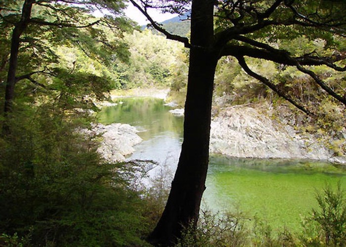
From the hut it's a sidle, largely out of sight of the river. After 30 minutes the track climbs to cut across a wide bend in the river, then descending again to a bridge over Fishtail Stream after a further 10 minutes. The track climbs away from the river before zigzagging steeply back down to a bridge over the Pelorus in 40 minutes. Captain Creek is soon forded on the bank of the Pelorus and the track climbs briefly before dropping down to the hut, which sits on a bend in the river.
There is ample space east of the hut for camping and, once again, good swimming in the river.
Captain Creek Hut-Emerald Pools Picnic Area: 2 hr, easy
After sidling for 40 minutes a benched climb leads out of earshot of the river and the high sidle begins. A brief climb after a further 40 minutes leads to a narrow spur that drops away steeply to the right. Twenty-five minutes on, the track ascends casually to its summit, a mere 320m, reaching it unceremoniously in 10 minutes. After a quick drop down to the river, take a short track to the right, leading to the Emerald Pools Picnic Area.
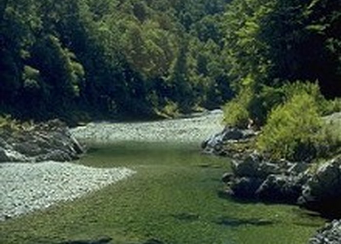
Emerald Pools Picnic Area (80m): picnic table, swimming.
There is a clearing here, although the trees close overhead. Camping would be very pleasant, although not at all private. A path leads down to a small sandy beach and water-worn rock outcrops by the pools, which, yet again, make for good swimming. The section of track into the picnic area has been upgraded: it's wide, smooth, and easy. Many people walk in to here to escape the crowds at Pelorus Bridge. The lower reaches of the Pelorus are also popular for fishing.
Emerald Pools Picnic Area-Mt Richmond Road Car Park: ¾ hr, very easy
A sunny track leads through regenerating bush, with gorse, manuka, bracken, and occasionally large clumps of Thelymitra and Pterostylis orchids flowering on the track side. It's 30 minutes to the small swingbridge which must provide some excitement for the day-trippers. This bridge marks the end of Mount Richmond Forest Park. The remainder of the track is a legal access-way. Fifteen minutes further, the gravel road leading to the gates of the Chehalem Valley Farm is encountered. If you walk up to the entrance of the farm, you can see two massive, conical sequoias growing in the distance. The car park is a minute further along (downstream) from the track end. Pelorus Bridge, where a DOC camping ground is situated, is 13km from here along a winding gravel road. Public transport runs through Pelorus Bridge, although transport to the road end itself may be harder to organise, and it's a long, hot, boring walk.