
Bending northward, the track follows the coastline at a distance, wandering through sandy plantation pine forest. While the walking is always very easy, locating the track can be difficult in the forest. Track markings are often unclear, and false trails seem to appear everywhere under the pines. Furthermore, there is nothing of interest in this direction.
While the section between Kaiapoi and the Pines Beach is a pleasant river-side walk, terminating at the Pacific Ocean, the northern section seems to have little to recommend it, provides navigational problems, and leads nowhere significant.
Walking along the beach, by the way, is even more tedious than walking through the forest. The dead slow curve of Pegasus Bay always presents the same impartial face, and it is very difficult to gauge distance. Don't try walking along the beach and cutting back to the walkway: you'll no doubt be fooled by the false trails over and over. If you want to walk along the beach, take a stroll at the Pines Beach, by all means, but return to the walkway where you left off.
Part of this walkway crosses private farmland. Do not disturb stock.
Access
The walkway begins at the bridge over the Kaiapoi River on Williams Street in Kaiapoi. Access is also available on Beach Road, and the Pines Beach. The walkway ends on Ferry Road near the camping ground at Woodend Beach. Public transport services the walkway, with a Christchurch bus (Rangiora) operating regularly between the Christchurch Square, Kaiapoi, and Woodend. It is another hour's walk from Woodend Beach to Woodend. Walkers are warned strongly against attempting to double back along the coastal section after reaching Woodend Beach: they would most likely die of boredom.
Kaiapoi - The Pines Beach: 1½ hr, very easy
From the bridge, follow the footpath next to the post office (true left) down-river past the wharf of the MV Tuhoe. The walk follows the top of a low stopbank as the willow-edged river bends slowly leftward. This stopbank is followed all the way to Beach Road. There are pied shags and ducks in the river, with welcome swallows around the bridge.
A road crossing from the left leads to a river-side picnic area, with toilets and a boat ramp. Soon the Kaiapoi River meets the Waimakariri River, but this moment is hidden behind trees. Crossing a stile onto private land, the path passes the end of Ferry Road, which is popular for fishing, and comes upon the oxidation ponds (0:30). There is a dense concentration of birds here that swirl into the air as a black cloud when disturbed: swans, ducks, white-faced herons, gulls, paradise shelducks, shags, and more.
Beyond a large field of raupo, the river views open up, and the mouth is visible not too far away, with the Brooklands Lagoon on the opposite bank. There are terns around here, and maybe some swans, with harriers, spur winged plovers, white-faced herons, and skylarks hanging around the farmland.
Disappointingly, the walkway stops short of the river mouth as it is trammeled by the small Saltwater Creek at the yacht club. Bending with the stopbank directly northward, the path follows the creek past private Kairaki yards and boat sheds to a little bridge on Beach Road (1:05).
Turning right and crossing the bridge, you'll soon come to an intersection. The road left leads to the Pines Beach settlement, right leads to Kairaki on the river mouth, and straight ahead leads to the surf club. The walkway doubles back upon itself rather senselessly here, and the best plan is to simply walk directly to the surf club.
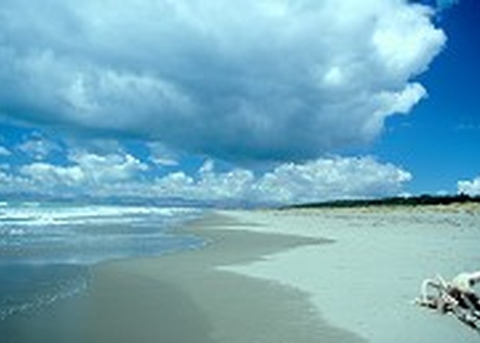
On an unmarked course, the walkway leads back down the Saltwater Creek in the grassy reserve next to Featherstone Avenue. As the grass peters out, the walkway crosses the road and enters cool plantation pine forest at the outskirts of Kairaki. The track divides several times confusingly: keep taking the left branch. With a bit of luck you should come out near the car park and the dilapidated surf club. the beach is a long slow curve in both directions, backed by high dunes. The grey sand is heavily strewn with wood, shells, and, sometimes, blue bottle jellyfish (do not touch these: even when dead, their stings are active).
The Pines Beach - Woodend Beach: 2 hr, easy-moderate
Pick up the walkway across the road, but be sure you have it as there are a lot of other tracks in the area. Look for DOC markers or old Walkways posts. Once on the walkway the track should be clear. The route is indicated by DOC markers at the regular junctions.
Before long, the track passes the Pines Beach Wetlands, where dotterels, bitterns, and the reclusive marsh crake live. Of course, for everything there is a season, and in the case of plantation pine, truer words were never spoken. Meandering through forest and following a logging road, the track soon crosses a large clear-felled area. This is at the time of writing -- in future this will perhaps be replanted while another section is laid to waste. Back in the forest on a sandy track, quail, fantails, and rabbits keep you company. Through the trees, tents and campers associated by the Woodend Camping Ground appear, and the track soon leads out to a picnic area on Ferry Road near the camping ground entrance.
If you are heading for Woodend, turn right on Ferry Road and walk down to Woodend Beach Road, which terminates at the camping ground. Turn inland and follow this road all the way to Woodend.