Buck Taylor Track - Parararha Stream Circuit
Waitakere Ranges Regional Park
- 3 hr – 3 hr 30 min loop track
- Medium
A short loop in the coastal Waitakere Ranges, visiting the lagoons of Pararaha Bay, and climbing the beautiful Pararaha Valley.
|
Walking time
|
3 hr – 3 hr 30 min |
|---|---|
|
Distance
|
6.0km |
|
Type
|
Loop track
|
|
Grade
|
Medium |
|
Bookings
|
No bookings — open access
No — open access
|
|
Starts
|
Car park, Lone Kauri Road, off Piha Road, Waitakere Ranges |
|---|---|
|
Maps
|
NZTopo50-BB30
|
|
Altitude
|
20m
–
298m
Altitude change 278m
|
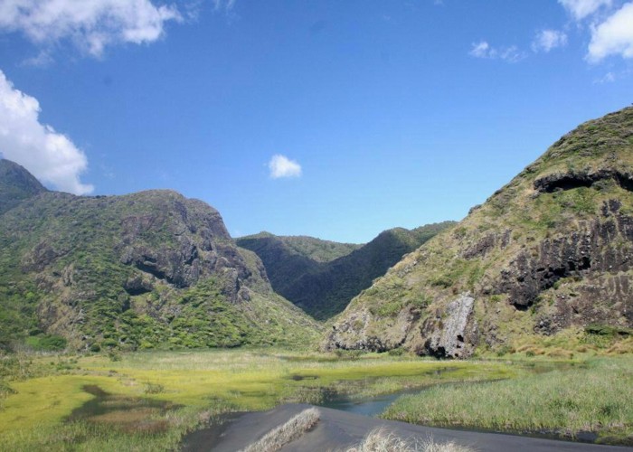
The southwestern corner of the Waitakere Ranges is a dramatic environment of narrow volcanic river valleys, steep breccia sea cliffs, and wide black sand beaches. This walk follows the straightforward Buck Taylor Track down to the lagoons at the back of the beach, then returns by a route up the Pararaha Valley. This route involves many river crossings, some boulder hopping, and route finding. Consider allowing some extra time to explore the coastline around Pararaha Bay.
From Waiatarua, take the Piha Road west, and turn off left at Lone Kauri Road. Look for a car park on the left after three side roads have led off to the right.
The Buck Taylor Track climbs easily through kanuka forest to a junction, before dropping easily along the face of a spur through patches of nikau forest. The Zion Hill Track leads along the cliff tops from Karekare in the north. This is met in 45 minutes, just before a final quick drop to Pararaha Bay and a track junction.
The bay is a wide landscape filled with wetlands and a substantial lagoon. The 5-minute boardwalked path past the lagoon is well worthwhile, providing good views of the coastal cliffs, the raw rock faces of Pararaha Point, a Manukau breccia, and the striking black sand dunes.
Back at the junction at the edge of the lagoon, a 10-minute track leads through grass and flax to the Pararaha Campsite, just beyond an easy stream crossing. A shelter and toilet are located here, although camping is by permit only (contact Auckland Regional Council). The striking dome of Baldy (223m) just north of the stream dominates the view.
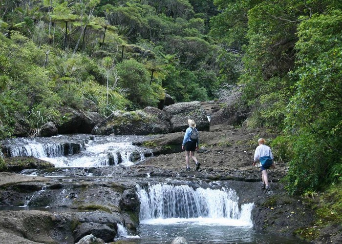
From the shelter, the Muir Track leads steeply up onto the clifftops. Ignore this track though and follow a trail alongside the stream. The track soon becomes a route, picking its way up the stream and crossing regularly as the gorge narrows and deepens. A series of pretty waterfalls lead all the way up the valley.
At a deep pool 30 minutes from the campsite, a track climbs out on the true right. This track clambers steeply past a larger waterfall to a striking pair of kauri. Above the fall, the stream eases off, and a couple more deep pools are avoided by tracks on the true left. Watch for these: they are very easy to miss.
The final track becomes an easy stroll, leading across a side stream and crossing the main stream a couple of times before meeting the wide Odlin Timber Track. From here, turn left, and it is an easy 10 minutes up steps back to the car park.