Mt Philistine
- 6 hr – 8 hr return via same track
- Medium/hard
Moderate to hard daytrip in Arthurs Pass.
|
Walking time
|
1 day
6 hr – 8 hr
|
|---|---|
|
Distance
|
8.0km |
|
Type
|
Return via same track
|
|
Grade
|
Medium/hard |
|
Bookings
|
No bookings — open access
No — open access
|
|
Starts
|
Otira Valley Carpark, SH79 near top of Arthurs Pass. ~800m north of Temple Basin goods lift |
|---|---|
|
Maps
|
NZTopo50-BV20
|
|
Altitude
|
900m
–
1,967m
Altitude change 1,067m
|
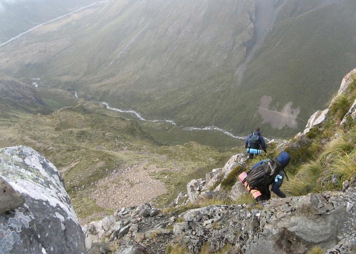
This is an exposed alpine route from Otira Valley carpark in Arthurs Pass to Mt Philistine Peak (1967m). Follow foot track 2km up the Otira Valley from the carpark to a footbridge. After crossing bridge, pick up cairned route to the north through tussock and scree leading to east end of Philistine Bluffs. Continue up cairned route through bluffs. This is exposed and care needs to be taken here - there have been accidents. After the bluffs, cairned route leads up through more easily graded but rocky terrain to summit. 100m from summit there are some exposed rocky sections and care needs to be taken here. There are permanent snowfields here in the summer. Our party used the north ridge to gain the summit. There were 1 or 2 short sections of easy, but exposed climbing needed. Views at the top look straight into the impressive north face of Mt Rolleston and the Otira Valley. Great views to the West and the Tasman Sea. Return via the same track, or it is possible to traverse to Waimakariri Col and the Waimakariri Falls Hut from here. This route description describes the track in summer. This description is probably not suited for winter access.