
It is possible to get permission from Esk Head Station to access Deep Creek road end to shorten this circuit. Their phone number is unavailable on the internet but can be obtained from DoC at Rangiora (03 313 0820). The current charge for access if fishing is at least $250 as professional guides take their clients there and the landowners who run this station as a tax loss would like to reduce fishing pressure. Not sure if he’s still one of the landowners but David Teece, ex-pat NZer is on the NBR Rich List and was at one time worth $170 million. He consulted in an advisory capacity on tax law. Get the picture?
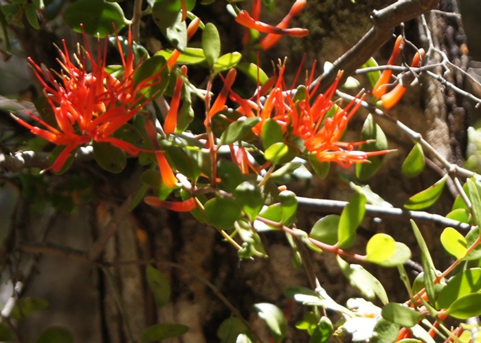
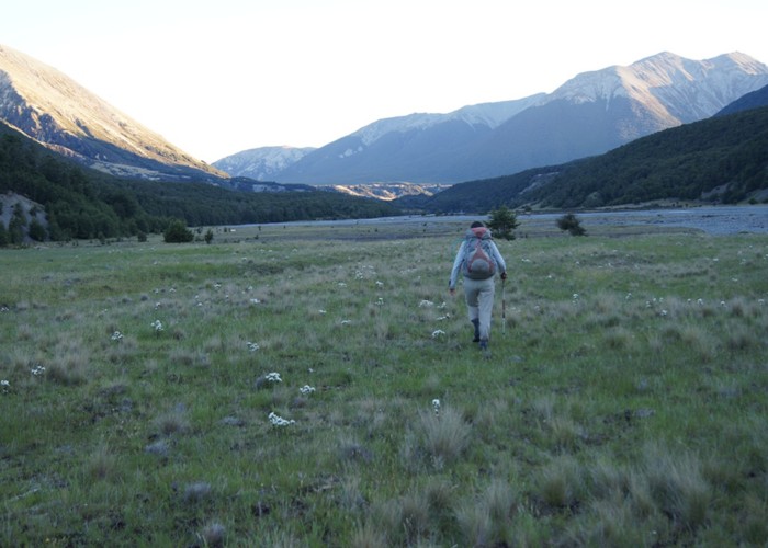
Anyway, we decided on this trip at short notice as rain was forecast in plan B (Lathrop/Zit Saddle circuit). So we came over a low saddle of 840 m on the Oronoko Range and up into the head of the South Hurunui, which involved a tedious 5 hour plod along cow shit infested 4WD tracks. However going over the Oronoko Range I spotted flowering mistletoe and this section is quite attractive which is a good thing as we decided to go back the same way in lieu of going past Lake Mason on our return.
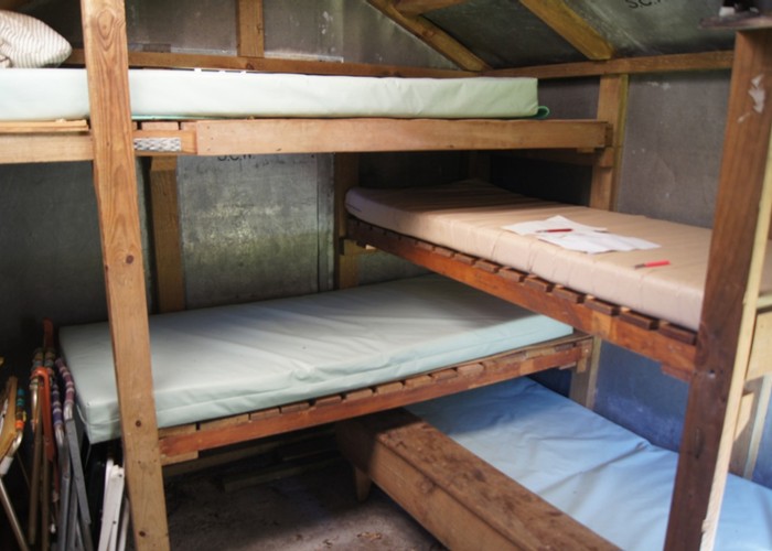
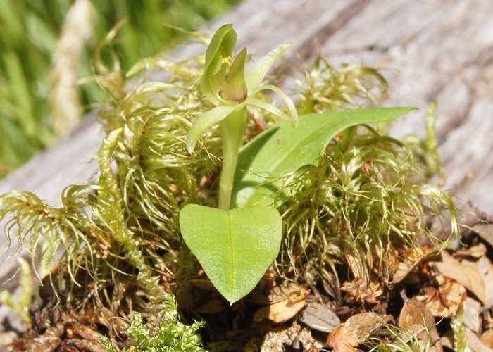
We crossed the South Hurunui to access the 4WD track that runs to the South Hurunui Hut and spotted a bull amid his harem. So we diverged into the matagouri, came back on the track and camped just short of the DoC research lodge. The South Branch hut was a contrast: beech framed and canvas bunks with an open fire. Here I observed little green flowering orchids in the shade.
We hadn’t researched the route over Roche Pass and down Ellis Stream but a lack of comment in the hut book indicated this would be straightforward, follow your nose type of travel. We went to a point up valley opposite the pass and confirmed that what had looked feasible on the map looked good on the ground and headed off up the slope. At a section of regen I moved to follow DoC trap markers sloping to the (climber’s) right and was advised to just head up the slope.
After pursuing this counter-intuitive gambit for a few metres I was advised to head right to ensure we were going up the correct spur. So this was fight number 1 as my instincts had told me to do this anyway and I’d been corrected off my intended course. I followed Frank and after a while observed blue sky at a low point on the horizon where the pass lay. I suggested we sidle more to the right in the direction of the dip where the pass lay instead of going up through steeper and scrubby terrain. 20 metres below from where we were sidling the vegetation was bigger and less scrubby.
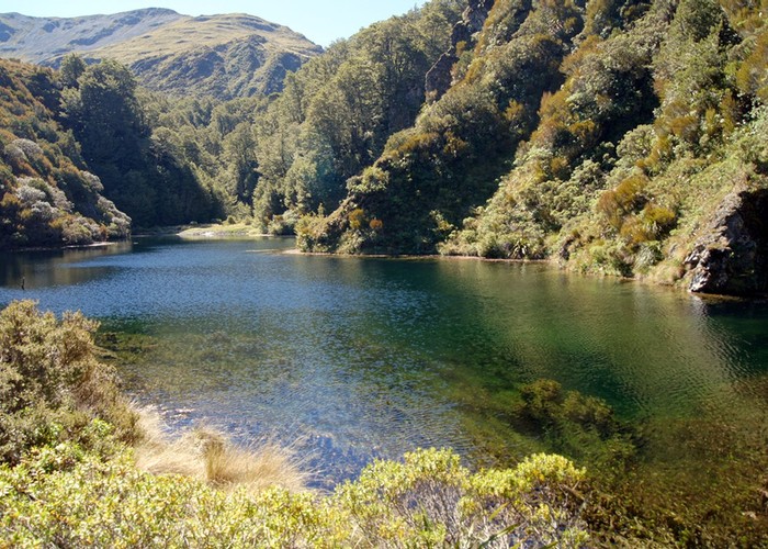
However Frank was following the GPS which suggested he keep going up towards point 1196, 70 m above the pass. So we did and topped out looking down on the pass to the west and a wee tarn. We undid the unnecessary height gain by dropping down to the bush margin just to the east of the larger tarn. Here there was a deer superhighway which soon petered out and we dropped down a very steep terrace to the outlet of the larger tarn. We were encouraged to take this route by cut marks at the top of this descent. Owen Pearson had made a comment in the South Branch Hut book advising people to exit from the larger tarn outlet via the true left and this is what we came down.
I backtracked a couple of metres to the outlet and the tarn was gorgeous. At the head was a little beach of grass. I wondered if it were possible to get down to this from the actual pass and camp sometime. From there the only way out would be to go back up as the sides of the tarn were near vertical cliffs about 30 m high. Frank came over and took some photos of this special place.
We began our descent of Ellis Ck. The end of the creek where it flowed into the Cox looked a bit twisting but I figured if there’d been no cautionary tale in the hut book, it would probably be navigable and so it proved to be and pretty enough as well. I guess shingle might have got sluiced down and filled it in so it wasn’t like Bristed Gorge, the measuring stick of gorges in my mind.
2 and a half hours after Roche Pass we came out into the bottom end of the gorge and where the riverbed widened we saw a grazing hind. There had been very little sign in Ellis Stream but plenty in the Cox, especially near the start of the gorge. Now we had a 10 km plod that would take us to the confluence with Bull Ck where the eponymous hut lay. I guessed we’d be at the hut in 3 hours and so we were. Luckily it was fast travel in the lower Cox.
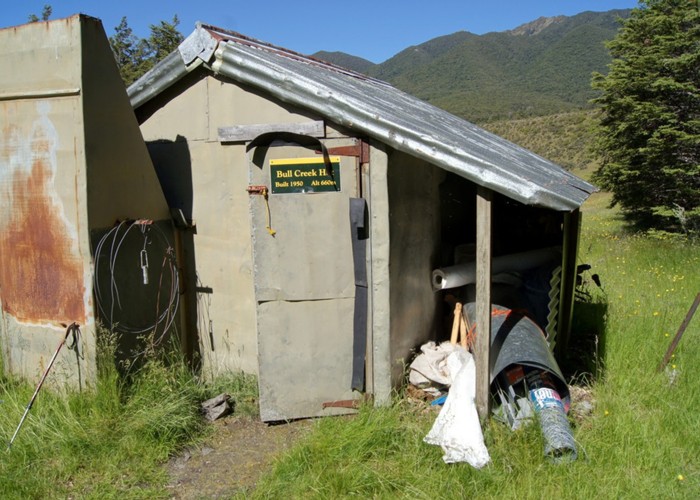
Bull Ck Hut had been on my wish list for some time but 2 thwarted attempts via McArthur gorge river flows had prevented me from getting there though prior to that I’d been to Lochinvar Hut twice using that route. Bull Ck’s 4 bunk configuration is evil and unnecessary. I came down from the top bunk and into the second teir while Frank chose the bottom bunk. Alright until you wanted to turn over when you’d be barking your shins on the bunk above. It was a hot day and the sandflies poured in through gaps in the hut and bit Frank who had eschewed repellant as he believes it melts his synthetic clothing. Well, he kept them away from me.
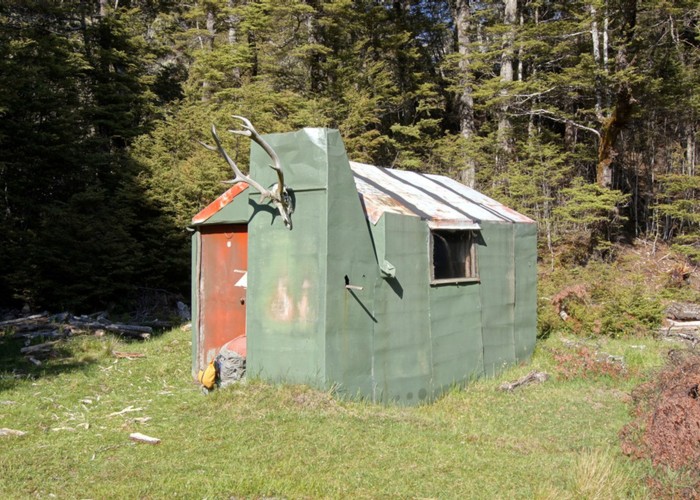
Craig Benbow of Permolat and his deerstalker buddies had flown long-drop loos in to the huts all over this area. Unfortunately the framing wasn’t solid enough to prevent the toilet door from slumping on this particular loo and it had hit the bottom frame. The tongue of the lock was consequently bent and inoperable but a rock kept the door closed for the time being. A bolt on the outside and a little latch on the inside might work better. The toilet made for a nice sandfly-free booth for costume changes. Building materials for renovations were stashed under a well-stocked woodshed lean-to. There was an impressive array of alcohol left in the hut including French brandy but we're teetotallers...
In the morning we studied the maps and ‘discussed’ the possible routes from here to Ant Stream Hut. The option of another tedious 4WD 20 km route march wasn’t even considered. We looked closely at the route between Shingle Hill and Big Flora. The bush option would involve a lot of navigation of gullies and spurs and possibly scrub bashing and Frank wasn’t keen. I suggested looking at a route over a low range on the eastern side with the highest point being point 1586 and this was agreed on. We strolled along the 4WD track with one deviation to avoid a bull. At this time of the year they are building and maintaining their harems against other bulls and can be a bit stroppy so we give them a wide berth. It was nice to actually get amongst the mounds of misery.
Frank suggested we take the shortest possible route through a tongue of forest north of point 886 in case the forest was unpleasant so we gained height up an old debris flow, and sidled, gaining height via short sections of small spurs which worked well. We emerged from the forest and had lunch by a small stream flowing from the southern face of Shingle Hill before we tackled the red tussock of the plateau and our 620 m ascent to Point 1586 in the hot sun.
On a hot day it’s best to ascend via spurs but Frank took the direct approach up the face to the first high point at 1420 m. He stopped halfway up as he was getting overheated. I had constantly wet my head to help keep me cool and had a pack weight half his - 10 kg for a 5 day trip - so I carried on slower than we had been going after a wee while and waited for him to catch up after his long break at the 1420 m contour.
We carried on to the summit and stopped to admire and in Frank’s case photograph the panorama presenting. All around us were peaks, ranges, flats and routes we’d done. Mt Turnbull still had patches of snow but Crossley (another summit we’d previously climbed) was bare. Black Rock was far off in the distance, and Dampier Corner, our highest point for the next day, looked easy travel via the rounded golden spurs we would take from Ant Stream. Chest Peak, Pember and Puketeraki were visible to the south with the Lazyman in front and on the other side of the Esk lay Mt White.
We continued to Point 1454 and Frank enquired of me my opinion for the descent route we should take to reach Ant Stream. I chose the option with the least vegetation and this we took. As we were dropping off the left hand spur following fresh hoof prints into a gully, I spotted a stag in velvet taking off. We took advantage of the gully as it was fairly open and free of vegetation particularly the dreaded matagouri.
We left the gully as it was heading down to a side stream and sidled, dropping height through open scrub making for easy travel. We came to the edge of this section overlooking Ant Stream and there were cows and one sheep that considered itself part of the herd grazing on grass. We dropped to the flat and Frank made a beeline to a thicket of beech. Aha, he must be following his GPS which is telling him where the hut is. We pushed our way through this and came to the side stream. From here we could see a structure – the new loo.
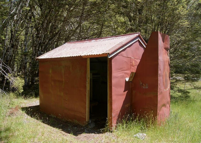
We checked the lock which was still good and Frank noticed the long drop hole hadn’t been dug. Just as well he did notice as it wouldn’t have been nice for the guys when it came time to shift the loo onto its resting space! I approached the hut door. I hope this hut isn’t as bad as Bull Creek said Frank. I opened the door – it only opened a foot then came to a halt on the uneven concrete floor. It’s worse, I said. I think we should camp tonight. There were 2 canvas bunks but the renovators had placed tyvek and tongue and groove on the bunks to store them out of the weather in the interim.
Someone had done a lot of work, replacing beech framing and windows. We suspected it was the Forresters as they come to this hut a lot. It is possible to take packhorses here from Anna Hut further down valley. The hut was virtually identical to Andersons Hut but the food cupboard doors had been removed and remade into a table. Some boy scout had also lashed together a wee table and a chair for outside furniture. Inside the hut, I commandeered a drum covered with a canvas mattress sack and poor Frank perched on a horrible wee seat constructed out of a section of tree trunk.
We put up the tent and zipped up the door as this place was sandfly city. After dinner I stole away in the dusk to the tent – mainly because my batteries were used up on one torch and the other torch was broken. Luckily the days are long this time of year. During the night we heard cattle lowing as they came back up the valley upstream of the hut with their sheep mascot.
Another fine day dawned but rain was predicted in the afternoon so an early start was required to ensure we were at Dampier Corner before the rain came. We set off down Ant Stream to the next tributary on the true left and my opinion was consulted on the strategy for ascent. I headed off and immediately came onto a deer trail but it drifted off towards the tributary after a short while. I pointed out to Frank that the map showed the bushline 60 m lower on the northern side of where we were heading so I’d aim for that. He said his GPS showed the bushline all at the same height on that slope. But we sidled climber’s left and came out in a scrubby clearing. Frank opined that 5 years this would all be closed up in beech forest as there was the odd small beech tree so a visit to Google Earth will be required then.
We reentered the forest briefly and I wondered if we were now following an old pack horse trail through this but didn’t see any evidence of cut marks. We headed up to the first summit, then beyond. I felt a bit tired so made sure I wasn’t trying to keep up with Frank. He waited for me at another high point and I leap-frogged, saying I would go slowly. He said I was faster than him but when I pointed out he’d got ahead and had to wait for me, he said if I went in front, I’d go faster. Off I went and got to point 1599, found a sheltered possie and decided to have a bit of lunch as I was getting hungry.
He arrived 7 minutes later and we shifted to the more sheltered side of the summit rocks for a complete lunch. After a while Frank realized we were not at Dampier Corner but it wasn’t far off. The first time I’d been there, I’d found a weta on the summit in a pile of rocks. We decided on which route to take down to the North Esk. Previously we’d gone directly from Dampier Corner to Lucy Stream via a reasonable spur with even-spaced contours. There were 2 deeply incised side streams to cross but last time Frank had selected crossing places above the embankments so they were no problem. We chose this way again and it was good travel.
We came on to the 4WD track and not longer after saw a bull in the distance so pussy footed onto lower terraces until we judged we were well past it. Woollies Stream came and it began to rain lightly. It was 5pm. We carried on and Frank spotted a bifurcation in the 4WD track leading down to lower terraces before Deep Creek Hut. I went for a look and confirmed it was leading down into the North Esk. We headed on down and there was a bridge which hadn’t been there last time so that was good. We toiled up onto the plateau surrounding Island Hills and travelled around it in a anticlockwise direction to cross the South Hurunui. When we saw yet another bull, we dropped down steeply to a series of lower terraces, avoiding matagouri and crossed the river. It had stopped raining.
Rain came on as we approached the verandah of a private hut so we sheltered here while Frank exchanged his trekking shoes for sandals as his soles were tender from trapped stones. If stones get in under your feet in sandals, you can kick them out easily as you walk along. I put on a brew as I had time on my hands and figured we’d be out before it got dark. We set off in light rain up over the Oronoko range again and down to where the car was parked by the lake.
Our stats for the trip were:
Day 1 16 km travelled with a total climb of 527 m
Day 2 31 km travelled with a total climb of 516 m
Day 3 16 km travelled with a total climb of 1079 m
Day 4 26 km travelled with a total climb of 1323 m and a descent of 1617 m
So a 90 km circuit with a total climb of 3445 m and 3 new huts bagged!
