Upper Ngakawau gorge foot access
- 2 hr – 3 hr return by the same track
- Hard
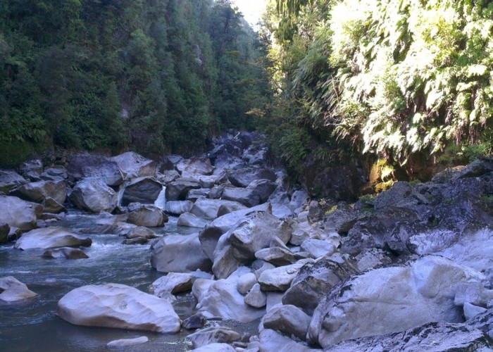
The Upper Ngakawau gorge is rugged and spectacular, yet seldom visited because of the difficulty of access, usually requiring a kayak in from the lower end.
|
Walking time
|
2 hr – 3 hr |
|---|---|
|
Type
|
Return by the same track
|
|
Grade
|
Hard
Off track travel with lots of cutty-grass and the odd wasp. Very steep descent into gorge, but no ropes required. Very large boulders in gorge make gorge travel challenging. Grades explained
|
|
Bookings
|
No bookings — open access
No — open access
|
|
Starts
|
Charming Creek walkway swingbridge |
|---|---|
|
Ends
|
Near the bottom end of the upper Ngakawau gorge |
|
Maps
|
-
|
The indistinct track to the top of Mangatini falls starts about 15m before the swingbridge over the Ngakawau river on the Charming Creek walkway. The track to the top of the falls is overgrown and difficult to follow in parts. It is marked on the map as ending at the top of the falls, but actually ends a bit further up Mangatini stream. Don't worry too much if you lose the track further up (as I did) - just bash towards the stream - this will give you a taste of what's to come anyway. Once you've crossed Mangatini stream head almost exactly due east to the small unnamed stream dropping in Ngakawau gorge. You might need to aim slightly south of east, so you intersect the stream before it begins it's precipitous plunge into the gorge. There's plenty of cutty-grass patches to negotiate; I recommend wearing pants and a long sleeve top - even on a hot day. Gloves would be useful too. You should be experienced in off-track direction finding in bush on flat ground - this is not the place to be going around in circles. Enough sunlight penetrates the bush that you can use the sun as a directional guide, once you know where the sun is in relation to your intended direction - but that's not much use if it's cloudy. Once you intersect the small stream, cross over onto it's true right. Follow the stream down until it starts to drop too steeply, then head right until you can safely descend. Continue a pattern of descending when it is safe to do so (and you know can get back up), and veering right when the descent is unsafe. There's a couple of places where you might have to lower yourself down a 1m drop using a well placed tree. When you emerge onto the floor of the gorge, erect a cairn (if my one is no longer there) so you can find your way back. There aren't really any other options for ascending out of the gorge around that point though. The stream ends in a waterfall about 30m downstream from where you emerge from the bush. Upstream about 1-200m is a giant jumble of massive boulders. I couldn't quite reach the boulder jumble because of the height of the river, but have been told that the going is slightly easier past those boulders. Also note that your GPS accuracy might suffer in the gorge - mine (from a smart phone) was sometimes out by hundreds of meters.