Arete Sidle track
- 3 hr – 5 hr return by the same track
- Medium/hard
Track between Cow creek Hut and Arete Forks hut in the Upper Waingawa valley in Tararua Forest Park.
From Arete Forks, a maintained track leads up to the Waiohine Pinnacles on Tarn Ridge.
|
Walking time
|
3 hr – 5 hr |
|---|---|
|
Distance
|
4.7km |
|
Type
|
Return by the same track
|
|
Grade
|
Medium/hard
Route sidles above Waingawa river gorge, makes, steep short climbs in some places Grades explained
|
|
Bookings
|
No bookings — open access
No — open access
|
|
Starts
|
At Cow creek hut |
|---|---|
|
Ends
|
Arete Forks hut |
|
Maps
|
NZTopo50-BN34
|
|
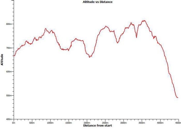
Altitude
|
490m
–
811m
Altitude change 321m
|
This track has a reputation for being difficult to follow and taking longer than expected. This is mainly due to the frequent climbs and descents the route follows, sidling above the steep Waingawa river gorge. There are 4 major sidestreams to traverse.
Frequent windfalls also make navigation difficult, at times.
The track is maintained by DOC, although it has been several years since the last effort. It is due for cutting in 2015. Regrowth of vegetation is generally ok, and is medium in some sections
Fit parties walking constantly should take between 3 to 4 hours. Allow for more if windfalls are present.
Many of the existing windfalls are marked with tape at present.(2014)
The actual track route climbs to 800 metres ASL (at the Cow Creek end), higher than indicated on the NZMS Topos
Alternate routes exist between Cow Creek and Arete Forks. The route up the Waingawa river bed follows a steep gorge that entails usually 2 or 3 pools that must be swum/pack floated. The river bed have sections of boulders and can be slow going. Since massive floods filled the gorge with gravel, making travel relatively easy, This debris has been washed away and the deep pools have returned. Allow 3 to 5 hours for this trip, and only in very low river conditions.
Another route traverses table ridge. A newly remarked track leads to the bushline above Cow Creek hut, leaving the Arete Sidle track after a 250 metre climb from Cow Creek. At the bushline the route is unmarked to the top of Table Ridge where a main spur descends Northwards down to Arete Forks. A stone cairn and stone markers indicate the start of this route. At the bush edge, the route follows an old largely unmarked and unmaintained track down to Arete Forks. care is needed in ensuring the correct spur is followed. The route connects with the Arete Sidle track a short distance about Arete Forks.This route can take 4 to 6 hours depending on fitness.
An old track leading up the waingawa river from Arete Forks and climbing onto Tarn ridge near Tarn Ridge Hut is no longer maintained and lower levels have been washed out by a massive slip that occurred several years ago.
Overall, the quickest route is by following the existing Arete Sidle track